IMAGES TAKEN NEAR TO
Strathleven Drive, ALEXANDRIA, G83 9PQ
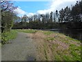
Introduction
This page details the photographs taken nearby to Strathleven Drive, G83 9PQ by members of the Geograph project.
The Geograph project started in 2005 with the aim of publishing, organising and preserving representative images for every square kilometre of Great Britain, Ireland and the Isle of Man.

There are currently over 7.5m images from over14,400 individuals and you can help contribute to the project by visiting https://www.geograph.org.uk
Image Map
Images are licensed for reuse under creativecommons.org/licenses/by-sa/2.0
Notes
- Clicking on the map will re-center to the selected point.
- The higher the marker number, the further away the image location is from the centre of the postcode.
Image Listing (95 Images Found)
Images are licensed for reuse under creativecommons.org/licenses/by-sa/2.0
Image
Details
Distance
1
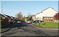
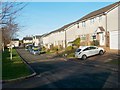
Ashley Rise, Strathleven Estate
This photograph was taken from the southern end of the street, where it meets Strathleven Drive.
Image: © Lairich Rig
Taken: 14 Nov 2010
0.10 miles
2
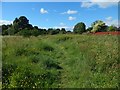
Path near Strathleven
The fence on the right is the boundary of the Strathleven Estate (housing). See Image for a view back along the path from near the other end.
Image: © Lairich Rig
Taken: 21 Jun 2018
0.11 miles
3
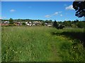
Path near Strathleven
See Image for a view in the opposite direction. The Strathleven Estate (housing) is in the background.
Image: © Lairich Rig
Taken: 21 Jun 2018
0.11 miles
4
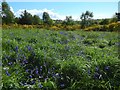
Strathleven grassland with bluebells
The line of gorse and trees not far ahead separates this area from the one shown in Image, which, as the map shows, is closer to the road (Burroughs Way, which is named after one of the factories that used to be in the industrial estate).
The grassy space shown in the present picture is farther from that road, but closer to Strathleven Estate (a housing estate: see http://www.geograph.org.uk/tagged/place:Strathleven+Estate for pictures). It can be reached by means of, for example, the path shown in Image
Image: © Lairich Rig
Taken: 22 May 2016
0.12 miles
5
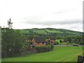
Vale of Leven, Dunbartonshire.
Looking towards Overton Muir.
Image: © Johnny Durnan
Taken: 18 Jun 2006
0.12 miles
6
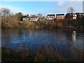
View across the River Leven
The view is from Cordale Point. The houses are at Strathleven.
Image: © Lairich Rig
Taken: 19 Dec 2018
0.13 miles
7
Lady's Gate, Strathleven Estate
This is a view from the southern end of the street. Directly behind the photographer's position is a meadow crossed by a footpath; in fact, the photograph was taken from the edge of the meadow, which is shown in Image and Image
Not far away is Image
Image: © Lairich Rig
Taken: 14 Nov 2010
0.15 miles
8
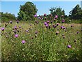
Hardheads / Black Knapweed
(Centaurea nigra)
This species, which, though not spiny, is clearly akin to thistles, is common in grassy places and rough ground throughout Britain and Ireland. In this case, the setting is Image
The title gives two of the plant's vernacular names, but there are others.
Image: © Lairich Rig
Taken: 23 Aug 2015
0.15 miles
9
Path around Cordale Point
This is the approach to the far end of the point. The picture was taken close to the part of the River Leven that anglers know as Sandy Hole, and not far from another part known as the Pikey.
There is a path above the steep bank on the other side of the Leven: Image
Image: © Lairich Rig
Taken: 8 Apr 2014
0.16 miles
10
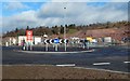
Mill Fields: a new roundabout
Stirling Road is in the foreground, and the Mill Fields construction site is in the background. An existing junction here has been given a new roundabout.
The red sign says "no right turn for construction traffic".
Image: © Lairich Rig
Taken: 20 Feb 2017
0.16 miles