IMAGES TAKEN NEAR TO
Strathleven Drive, ALEXANDRIA, G83 9PG
Introduction
This page details the photographs taken nearby to Strathleven Drive, G83 9PG by members of the Geograph project.
The Geograph project started in 2005 with the aim of publishing, organising and preserving representative images for every square kilometre of Great Britain, Ireland and the Isle of Man.

There are currently over 7.5m images from over14,400 individuals and you can help contribute to the project by visiting https://www.geograph.org.uk
Image Map
Images are licensed for reuse under creativecommons.org/licenses/by-sa/2.0
Notes
- Clicking on the map will re-center to the selected point.
- The higher the marker number, the further away the image location is from the centre of the postcode.
Image Listing (136 Images Found)
Images are licensed for reuse under creativecommons.org/licenses/by-sa/2.0
Image
Details
Distance
1
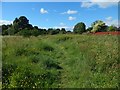
Path near Strathleven
The fence on the right is the boundary of the Strathleven Estate (housing). See Image for a view back along the path from near the other end.
Image: © Lairich Rig
Taken: 21 Jun 2018
0.04 miles
2
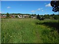
Path near Strathleven
See Image for a view in the opposite direction. The Strathleven Estate (housing) is in the background.
Image: © Lairich Rig
Taken: 21 Jun 2018
0.05 miles
3
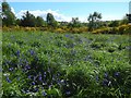
Strathleven grassland with bluebells
The line of gorse and trees not far ahead separates this area from the one shown in Image, which, as the map shows, is closer to the road (Burroughs Way, which is named after one of the factories that used to be in the industrial estate).
The grassy space shown in the present picture is farther from that road, but closer to Strathleven Estate (a housing estate: see http://www.geograph.org.uk/tagged/place:Strathleven+Estate for pictures). It can be reached by means of, for example, the path shown in Image
Image: © Lairich Rig
Taken: 22 May 2016
0.06 miles
4
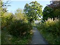
Path to Strathleven Estate
This path is shown on the 1:25000 OS map. It passes not far to the north of Image, and leads from the Vale of Leven Industrial Estate to Strathleven Estate, the latter being an area of housing (the houses visible beyond the far end of the path are located there).
Image: © Lairich Rig
Taken: 8 Oct 2012
0.08 miles
5

Northern Marsh-orchid (Dactylorhiza purpurella)
The picture was taken in an area of Image, at a time when several examples of this species were visible. A little later in the year, Spotted-orchid species become abundant here, and some Butterfly-orchids can also be seen.
Image: © Lairich Rig
Taken: 13 Jun 2013
0.09 miles
6
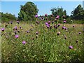
Hardheads / Black Knapweed
(Centaurea nigra)
This species, which, though not spiny, is clearly akin to thistles, is common in grassy places and rough ground throughout Britain and Ireland. In this case, the setting is Image
The title gives two of the plant's vernacular names, but there are others.
Image: © Lairich Rig
Taken: 23 Aug 2015
0.09 miles
7
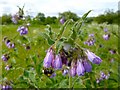
Russian Comfrey
(Symphytum × uplandicum)
This hybrid of S. officinale (Common Comfrey) and S. asperum (Rough Comfrey) is very common. For context, see Image Note the conspicuous pollen basket on the bee. The froth near the centre of the picture is the product of a different insect, the froghopper.
Image: © Lairich Rig
Taken: 13 Jun 2013
0.09 miles
8
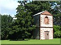
Doocot near Strathleven House
In the 1970s, before nearby Strathleven Estate had been built, this tower was hidden away in a dense tangled wood, and it was necessary to climb over low gnarled tree branches to reach it. The tower, which is close to Strathleven House (Image), now stands in the open, with an area of grass in front of it, and a little pool behind.
The structure is a category A listed building. I had been informed that it was a game tower, where meat was hung to be tenderized, and at least one printed work describes it in the same way. However, the listed building report describes it as a doocot; the book "North Clyde Estuary - An Illustrated Architectural Guide" (Frank Arneil Walker with Fiona Sinclair), gives a similar description: "a doocot, early 18th century, a two-storey square structure pedimented on the north and south. The upper chamber, containing stone nesting boxes, sits on a vaulted ground floor".
The County Reporter (local newspaper), in its issue of 5.1.1977, has the following to say about the doocot: "At the back of the mansion, hidden among tall trees, you will find the dovecote. On the same scale as everything at Strathleven, it is stone-built, stands thirty or forty feet high, and could almost house a human family. Time, weather and neglect have made it a semi-ruin, but where the roof has fallen in, tier upon tier of square pigeon holes are still visible. The pigeons have long since vanished, and their place was taken latterly by white owls".
The article, by G R Stocks, goes on to mention the Roman distance slab that was built into the wall of the doocot. It is said to have been found on the line of the Antonine Wall at Low Millochan (now East Millichen) in 1803. It is elsewhere noted that the stone, when it was built into the doocot, was weathering badly; it was then protected for a while by glass (which was later broken). The stone was finally donated to Glasgow Art Gallery and Museum in 1942.
The stone, a distance slab of the Sixth Legion, is discussed (as stone № 13) on pages 298-300 of "The Roman Wall in Scotland" (1911, George MacDonald), and is illustrated (again, as № 13) in a plate facing page 298 of that book. Its inscription is as follows:
IMP·CAES·T
AELIO·HADRIA
ANTONINᵒ·AVG
PIO·P·P·VEXILLA
LEG·V̅I̅·VIC·P·F·
PER·M·P·IIIDCLˣVIS
See https://canmore.org.uk/site/44473/east-millichen (at Canmore) for a description.
As noted in that Canmore report, it is now thought likely that this stone was originally next to the one mentioned at Image (a distance slab of the Second Legion), though determining where these stones were originally found has been problematic.
That other stone (formerly thought to have been found at Castlehill) is discussed, as № 11, on pages 288-292 of MacDonald's book, and is illustrated on a plate facing page 288. The author concludes that the two stones were "originally companions", and that it is probable that both were found near the farm of Summerston.
Image: © Lairich Rig
Taken: 4 Aug 2008
0.10 miles
9
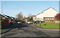
Ashley Rise, Strathleven Estate
This photograph was taken from the southern end of the street, where it meets Strathleven Drive.
Image: © Lairich Rig
Taken: 14 Nov 2010
0.10 miles
10
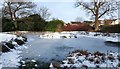
Frozen pond near Strathleven House
The pond is located in a wooded area about 200 metres ENE of Image
The houses in the background are in Strathleven Estate.
For other views, see Image and Image
Image: © Lairich Rig
Taken: 1 Jan 2010
0.12 miles