IMAGES TAKEN NEAR TO
Willowbank Grove, ALEXANDRIA, G83 9GE
Introduction
This page details the photographs taken nearby to Willowbank Grove, G83 9GE by members of the Geograph project.
The Geograph project started in 2005 with the aim of publishing, organising and preserving representative images for every square kilometre of Great Britain, Ireland and the Isle of Man.

There are currently over 7.5m images from over14,400 individuals and you can help contribute to the project by visiting https://www.geograph.org.uk
Image Map
Images are licensed for reuse under creativecommons.org/licenses/by-sa/2.0
Notes
- Clicking on the map will re-center to the selected point.
- The higher the marker number, the further away the image location is from the centre of the postcode.
Image Listing (96 Images Found)
Images are licensed for reuse under creativecommons.org/licenses/by-sa/2.0
Image
Details
Distance
1
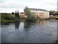
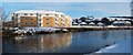
New housing, Bonhill
Riverside flats going up on what was the site of a factory.
Image: © Richard Webb
Taken: 1 Sep 2009
0.01 miles
2
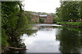
River Leven
View of the River Leven and Dalmonoch Works which has now been demolished
Image: © George Rankin
Taken: 4 Jun 2006
0.02 miles
3
Gregs Mill
This is what was left of Dalmonoch Works Bonhill now demolished in late 2006 and soon will be a housing development
Image: © Eddie Mackinnon
Taken: 6 Mar 2005
0.04 miles
4
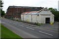
Greigs Mill
J & W Greig Ltd, Yarn Spinning Mills Dalmonach Works, Alexandria, Dunbartonshire
This used to a Wool and Yarn Mill and has now been knocked down to build Flats and Houses the white building used to be a Garage for many years.
Image: © George Rankin
Taken: 4 Jun 2006
0.04 miles
5
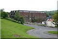
Levenbank
When this photograph was taken, the Levenbank housing development was still partly under construction, although some houses were already occupied. For another view, see Image See Image for a view from within the development.
The site had formerly been occupied by the remnants of Dalmonach Print Works; for the buildings that were on the site just before demolition cleared the way for the new housing development, see Image, Image, and Image
Image: © Lairich Rig
Taken: 29 Nov 2010
0.05 miles
6
Bradleys Garage
Main Street Bonhill, Bradleys Garage, white building now demolished and Greigs Mill in background.
Image: © George Rankin
Taken: 4 Jun 2006
0.06 miles
7
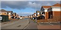
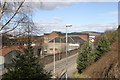
Levenbank
Levenbank is a housing development, built in the last few years on what had previously been the site of Image Behind the photographer's position, the former site of Image is now occupied by part of the same development (for other views of the now-demolished structures that used to be here, see Image and Image).
See also Image, a view from the other side of the river.
Image: © Lairich Rig
Taken: 6 Feb 2013
0.06 miles
8
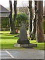
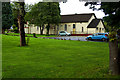
150th Anniversary Memorial at Our Lady and St Mark's
For context, see Image, where the memorial is located just in front of the middle of the long side of the church building.
The inscription: "On the occasion of the 150th Anniversary of the founding of Our Lady and St Mark's we remember the priests and parishioners who have served, are serving, and will serve this parish. Deo Gratias. 1859-2009."
Image: © Lairich Rig
Taken: 1 Jan 2013
0.07 miles
10
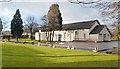
Our Lady and St Mark's
This is a view of the church from the footpath and cycle route alongside the River Leven. A small Celtic cross standing on the near side of the building commemorates the church's 150th anniversary, which was in 2009: Image
Image: © Lairich Rig
Taken: 1 Jan 2013
0.07 miles