IMAGES TAKEN NEAR TO
Ladyton Shopping Centre, ALEXANDRIA, G83 9DZ
Introduction
This page details the photographs taken nearby to Ladyton Shopping Centre, G83 9DZ by members of the Geograph project.
The Geograph project started in 2005 with the aim of publishing, organising and preserving representative images for every square kilometre of Great Britain, Ireland and the Isle of Man.

There are currently over 7.5m images from over14,400 individuals and you can help contribute to the project by visiting https://www.geograph.org.uk
Image Map
Images are licensed for reuse under creativecommons.org/licenses/by-sa/2.0
Notes
- Clicking on the map will re-center to the selected point.
- The higher the marker number, the further away the image location is from the centre of the postcode.
Image Listing (16 Images Found)
Images are licensed for reuse under creativecommons.org/licenses/by-sa/2.0
Image
Details
Distance
1
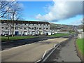
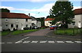
Bonhill, West Dunbartonshire
The Ladyton and O'Hare areas to the north.
Image: © Stephen Sweeney
Taken: 4 Mar 2012
0.08 miles
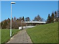
3
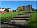
Steps at Ladyton
A housing association is carrying out work on the building at the top of the steps, and on others nearby (out of shot).
Image: © Lairich Rig
Taken: 14 Oct 2018
0.11 miles
4
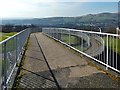
Footbridge over road
This is the footbridge that is marked as "FB" on the 1:25000 OS map. It leads from Pappert (near side) to Ladyton (for a view back towards this footbridge from the section of path visible on the left, see Image).
The houses in the middle distance, on the right, are in Ladyton, but those in the background are in Renton and Alexandria. Carman Hill (Image) and adjacent muirs are in the background, on the right.
Image: © Lairich Rig
Taken: 24 Feb 2014
0.14 miles
5
Path and footbridge
The path is marked on the 1:25000 OS map, as is the footbridge (as "FB"), which crosses above a road, and which leads from Ladyton (on this side) to Pappert. There is sometimes the temptation to bypass a winding footbridge by crossing the road directly, but not here: the houses on the Pappert side sit above a steep high bank.
For a view in the opposite direction from on top of the footbridge, see Image In that photograph, the section of path from which the present picture was taken can be seen on the left, with the same lamp posts visible.
Image: © Lairich Rig
Taken: 24 Feb 2014
0.14 miles
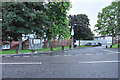
6
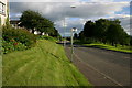
A813 Ladyton Bonhill
View along the A813 at Ladyton Bonhill looking south this is the main route between Balloch and Bonhill to Dumbarton and Glasgow
Image: © George Rankin
Taken: 25 Jun 2007
0.16 miles
7
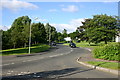
Towards O'Hare Estate
View looking from the junction on the A813 looking towards O'Hare Estate Bonhill
Image: © George Rankin
Taken: 25 Jun 2007
0.18 miles
8
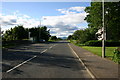
A813 Ladyton Bonhill looking North
View along the A813 near Ladyton Bonhill looking North, at the end of the road can be seen Ben Lomond in the distance.
Image: © George Rankin
Taken: 25 Jun 2007
0.18 miles
9
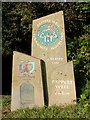
Start of footpath to Pappert Hill
These markers, indicating the start of the footpath, stand beside the road that bounds O'Hare on the north. From this point, the footpath heads north for a few yards, crossing a stream by means of a footbridge; it then turns to the east, towards Pappert Hill (Pappert Well can also be reached using this footpath).
Image: © Lairich Rig
Taken: 16 Oct 2008
0.21 miles
10
Raglan Street Lane Bonhill
View of Raglan Street Lane, Bonhill from George Street looking East.
Image: © George Rankin
Taken: 25 Jun 2007
0.22 miles