IMAGES TAKEN NEAR TO
Gartocharn, ALEXANDRIA, G83 8RS
Introduction
This page details the photographs taken nearby to G83 8RS by members of the Geograph project.
The Geograph project started in 2005 with the aim of publishing, organising and preserving representative images for every square kilometre of Great Britain, Ireland and the Isle of Man.

There are currently over 7.5m images from over14,400 individuals and you can help contribute to the project by visiting https://www.geograph.org.uk
Image Map
Images are licensed for reuse under creativecommons.org/licenses/by-sa/2.0
Notes
- Clicking on the map will re-center to the selected point.
- The higher the marker number, the further away the image location is from the centre of the postcode.
Image Listing (10 Images Found)
Images are licensed for reuse under creativecommons.org/licenses/by-sa/2.0
Image
Details
Distance
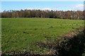
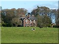
1
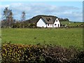
Ben Ard
A short track leads from Image, past Image, to this house, which is called Ben Ard. West Lodge was associated with Image, and the track is a small surviving stretch of a road that once connected the two.
The wooded hill behind Ben Ard is Image
Image: © Lairich Rig
Taken: 19 Oct 2011
0.01 miles
2
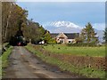
West Lodge
This building was the West Lodge of Image, despite there now being no road connecting the two. There used to be two such roads, fairly close together, as shown on early OS maps. At the time of writing, their course can still be discerned on satellite mapping.
The picture was taken from Image, which appears in the foreground. From that road, a track now only extends 140 metres, passing West Lodge, and providing access to its near neighbour, a house called Image, which is out of shot to the right.
The backdrop to the former lodge is Ben Lomond (Image), which had only recently acquired its first snow cover of the season.
Image: © Lairich Rig
Taken: 19 Oct 2011
0.07 miles
4
School Road
The road leads from the village of Gartocharn towards a route that is known locally as the Horseshoe. Not far ahead, a Image branches off to the left. Further ahead, the building on the right, among the trees, is Cambus Lodge (Image). The top of another house, Image, is visible on the left.
For another part of the road, see Image
Image: © Lairich Rig
Taken: 19 Oct 2011
0.17 miles
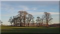
5
Blackhill Plantation
The first-edition OS map (surveyed in 1860) does not name the plantation, but, along the edges of the plantation, that map does include several features, including some buildings that have since disappeared: Blairoaks Cottage (was at Image) and Blairoaks (c.Image), and a road that led WNW past both of them towards the still-extant Blairlusk; a couple of old quarries (disused even then), at c.Image and Image
The name Blairoaks is apparently a descendent of the Blarokes that is shown in Roy's Military Survey of Scotland (1740s-50s). The Blairoaks of the first-edition map had disappeared by 1899, and Blairoaks Cottage eventually followed, after lingering as an unnamed ruin for a number of years. The name survives in Blairoaks Plantation, just to the north of Caldarvan Loch.
The equivalent map from 1899 gives the present-day names of Blackhill Plantation and Image (which is just to the south-east, the two forming a single horseshoe-shaped area of woodland).
Image: © Lairich Rig
Taken: 19 Oct 2011
0.19 miles
6
Track to Mid Cambusmoon
Image: © Lairich Rig
Taken: 19 Oct 2011
0.22 miles
7
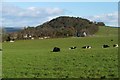
Mid Cambusmoon
The farm buildings are visible at the foot of a hill which is known locally as Image On the name Cambusmoon, see Image See also Image and Image
Image: © Lairich Rig
Taken: 19 Oct 2011
0.23 miles
8
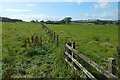
Field boundary
The line of this fence is marked on the 1:25000 map.
Image: © Lairich Rig
Taken: 5 Sep 2019
0.24 miles
9
Caldarvan House
The lands of Caldarvan and part of Wester Finnary were acquired in 1802 by Robert Mackenzie.
His grandson, R. D. Mackenzie (Robert Duncanson Mackenzie) of Caldarvan was born in Cardross in August 1812, and graduated with an MA from Glasgow University in 1830. His career as a writer (i.e. lawyer) began in Dumbarton in 1836, but for the bulk of his career he worked in Glasgow, where he joined the firm of Couper, Mackenzie and Innes, which later become Mackenzie, Robertson and Co. He was also involved in public administration; as early as 1834, he served as Commissioner of Supply; later he was Convener of the Town Council. He retired from the council in 1894.
He succeeded to Caldarvan on his father's death in 1825. The listed building report for Caldarvan House describes it as mid- to later nineteenth century, and lists some architectural features, but does not name the architect or give any details about its occupants (for the building's former west lodge, see Image).
However, R. D. Mackenzie's obituary, published in the Lennox Herald newspaper, in its issue of the 27th of March, 1909, provides some additional details: he added to and greatly beautified Caldarvan Estate, and was particularly keen on planting trees, transforming what had been bare countryside. The obituary notes that Caldarvan "had a wide reputation for the excellence of its collection of rhododendrons". R. D. Mackenzie rebuilt the mansion house in 1840; it had to be rebuilt again in 1905, after being burnt down.
He also became owner of Cambusmoon, Easter Finnary, the Mill and Mill Lands of Mavie (Image – see also http://www.geograph.org.uk/photo/1153458 on the name Mavie Mill), and part of Blairquhomrie (Image).
He was a senior partner in the firm of Mackenzie, Gardner, and Alexander, Glasgow (probably a continuation of the company that was mentioned above under two different names). He was, for almost fifty years, a member of the board of the City of Glasgow Life Assurance Company. In 1842, he married Susan Campbell, daughter of Sheriff Alexander Campbell of Barnhill (on that family connection, see Image). The couple had five daughters, and one son, Robert Mackenzie, junior (who also became a partner in the firm of Mackenzie, Gardner, and Alexander).
R. D. Mackenzie died in his 97th year (on Friday, March 19th, 1909) at his home in Caldarvan. He was buried in the family burial place in Dumbarton Cemetery (see link, above, for the Campbells of Barnhill). In the afternoon, a service was conducted at Caldarvan, conducted by the minister of Kilmaronock Parish.
There is a portrait of R.D.Mackenzie in the third volume of Joseph Irving's "Book of Dumbartonshire" (1879). Much of the above information was drawn from the second and third volumes of that work.
The Pont/Blaeu map of the Lennox (surveyed in the 1580s-90s) includes the name Caldarvan (as Kaildaruan), with Cambusmoon to the north (as Kammezmore) (*). In Roy's Military Survey of Scotland, these two places appear as Kildervan and Camismoon, respectively. On a 1777 map by Charles Ross, they are Culdervan and Campsmune, while John Ainslie's map of southern Scotland shows Culdervan (by itself).
By the time of the first-edition OS map (surveyed in 1860), they have their present-day names: Caldarvan to the south, and Cambusmoon (Image) to the north (flanked by East and Image).
The name Caldarvan is now associated with some other features in the area, but these were earlier known by other names. For example, Caldarvan Loch had, at an earlier period, been called Loch Breach (or similar). By the time of the first-edition OS map (c.1860), it was known as Lochend; although R.D.Mackenzie insisted that it be renamed Caldarvan Loch, and that this name be shown on the OS map, locals still call it Lochend: see Image for the details.
Likewise, Image was earlier called Kilmaronock Station (Kilmaronock is the name of the parish), but it was also renamed, again at the insistence of R.D.Mackenzie; see the last-cited link for further details.
- - • - -
(*) On the changes undergone by the name Kammezmore (to Cambusmoon), compare Camis Eskan (Image, near Helensburgh): that name was formerly written as one word, Camiseskan, and, on the Pont/Blaeu map, it is called Kammezeskan (very similar to the Kammesmore that appears, for modern Cambusmoon, on the same map). On subsequent maps, the changes in its name were almost parallel to those of Kammezmore/Cambusmoon. For Camis Eskan, The Lennox Cartulary gives a couple of other old forms: Camceskanys (1333-1364) and Camseskaines (1680).
In both of the place-names (Camis Eskan and Cambusmoon) the first element is the same: the Gaelic "camas" (sometimes spelled "camus"). In "Camis Eskan", "camas" signifies a broad curving bay, while in "Cambusmoon", the same Gaelic word denotes land within the bend of a burn. The meanings may seem unrelated, but "camas" is from a root meaning "crooked", "bent", "curved", "twisted"; from this, it can be seen why it might be applied to the curve of a bay or that of a watercourse. For more, see Dwelly's Gaelic dictionary, and its entries for "camus", "cam", and various other "cam—" words.
Image: © Lairich Rig
Taken: 19 Oct 2011
0.24 miles
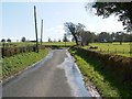
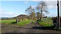
10
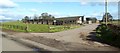
Ardgate Farm
The farm is located beside Image, which leads from the Horseshoe to the village of Gartocharn.
According to a lady whom I met on the day, the name of the farm was changed to avoid confusion with nearby Image This is borne out by early OS maps: the first-edition map (surveyed c.1860) calls this farm West Caldarvan, and it is shown by that name until at least the 1950s (although it is possible that the name change took place earlier, and that the maps did not immediately reflect it). After that, the present-day name Ardgate is shown.
For another view of the farm, see Image
Image: © Lairich Rig
Taken: 19 Oct 2011
0.25 miles