IMAGES TAKEN NEAR TO
Gartocharn, ALEXANDRIA, G83 8RR
Introduction
This page details the photographs taken nearby to G83 8RR by members of the Geograph project.
The Geograph project started in 2005 with the aim of publishing, organising and preserving representative images for every square kilometre of Great Britain, Ireland and the Isle of Man.

There are currently over 7.5m images from over14,400 individuals and you can help contribute to the project by visiting https://www.geograph.org.uk
Image Map
Images are licensed for reuse under creativecommons.org/licenses/by-sa/2.0
Notes
- Clicking on the map will re-center to the selected point.
- The higher the marker number, the further away the image location is from the centre of the postcode.
Image Listing (13 Images Found)
Images are licensed for reuse under creativecommons.org/licenses/by-sa/2.0
Image
Details
Distance
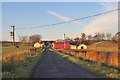
1
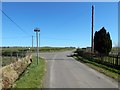
Road junction near Lochend
Branching off to the left is a short road leading to Lochend. The sign near the junction indicates that NCN 7 and the John Muir Way continue straight ahead.
Image: © Lairich Rig
Taken: 18 Apr 2014
0.03 miles
2
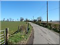
Road at Easter Blairquhanan
The nearest building is Easter Blairquhanan Cottage; Rosedale and Lochfern are a little further ahead.
Image: © Lairich Rig
Taken: 18 Apr 2014
0.08 miles
3
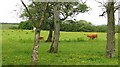
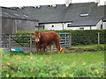
Cattle, Lochend
Caldervan Loch is not easily glimpsed, it is behind the trees at the back of this field.
Image: © Richard Webb
Taken: 15 Jun 2010
0.08 miles
4
Lochend, Caldarvan
Caldarvan Loch is just behind the buildings.
Image: © Richard Sutcliffe
Taken: 1 Mar 2016
0.10 miles
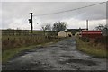
6
The farmstead of Lochend
Immediately behind the farm lies Caldarvan Loch.
Image: © Alan Reid
Taken: 30 Nov 2014
0.14 miles
7
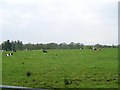
Several cows in field
Near Easter Blairquhanan.
Image: © Stephen Sweeney
Taken: 10 May 2008
0.15 miles

9
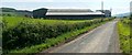
East Blairquhanan Farm
Image: © Lairich Rig
Taken: 29 Jul 2011
0.20 miles
10
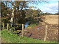
The Cranloch Burn
The photograph was taken from the road; the picture Image was taken from about the same point.
Cranloch is the name of a nearby house. The Cranloch Burn flows from Caldarvan Loch (Image), and joins with others to form the Carrochan Burn.
Caldarvan Loch itself is the "L. Breeck" that is shown on the Pont/Blaeu map of the Lennox (surveyed 1580s-90s), and which is called "Loch Breach" in Roy's Military Survey of Scotland (1740s-50s).
On the day I took this photograph, I was told that, despite the name on the map, local residents do not call the body of water "Caldarvan Loch". When surveying was being carried out for the first-edition OS map (c.1860), the loch was apparently known as Lochend (a name that is still applied to the buildings on its southern side). However, the OS Name Books record what appears to have been a quite peremptory request on the part of the "proprietor" (who was Mr R.D.Mackenzie of Image).
The relevant entry in the OS Object Name Book is as follows: "Caldarvan Loch (other names: Lochend) – The proprietor wishes this loch to be in future called by the name supplied. That by which [it] is popularly known is Lochend."
He may have had his way as far as the OS map goes, but local residents have a longer memory. This was not the only feature whose name Mr Mackenzie wished to change; it was also at his request that Kilmaronock Station (named after the parish in which it is located) was renamed Image
Image: © Lairich Rig
Taken: 19 Oct 2011
0.20 miles