IMAGES TAKEN NEAR TO
Dalvait Road, ALEXANDRIA, G83 8QF
Introduction
This page details the photographs taken nearby to Dalvait Road, G83 8QF by members of the Geograph project.
The Geograph project started in 2005 with the aim of publishing, organising and preserving representative images for every square kilometre of Great Britain, Ireland and the Isle of Man.

There are currently over 7.5m images from over14,400 individuals and you can help contribute to the project by visiting https://www.geograph.org.uk
Image Map
Images are licensed for reuse under creativecommons.org/licenses/by-sa/2.0
Notes
- Clicking on the map will re-center to the selected point.
- The higher the marker number, the further away the image location is from the centre of the postcode.
Image Listing (166 Images Found)
Images are licensed for reuse under creativecommons.org/licenses/by-sa/2.0
Image
Details
Distance
1
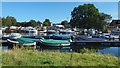
Boats at Balloch
The view is from near the Angling Club's buildings.
Image: © Lairich Rig
Taken: 20 Sep 2019
0.06 miles
2
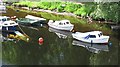
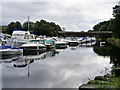
River Leven
Just downstream from Loch Lomond. Note the sunken boat amongst the moorings.
Image: © Richard Webb
Taken: 15 Jun 2010
0.07 miles
3
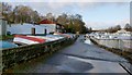
Vale of Leven District Angling Club
The club's buildings are on the left. On the right is a cycle path / footpath that follows the western side of the River Leven. For the bridge visible ahead, see Image
Image: © Lairich Rig
Taken: 1 Jan 2013
0.09 miles
4
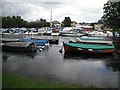
River Leven, Balloch
Full of moored boats that are used on Loch Lomond.
Image: © Richard Webb
Taken: 4 Mar 2009
0.09 miles
5
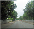
Lomond Road Balloch east of Leven bridge
Image: © John Firth
Taken: 26 Jul 2012
0.09 miles
6
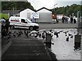
Under Balloch Bridge
Duck feeding beside the Leven, here just starting its short journey from Loch Lomond.
Image: © Richard Webb
Taken: 1 Sep 2009
0.09 miles
7
Bridge (Lomond Road) over the River Leven
Reckoning from north to south, this is the second bridge over the River Leven. For a side view, see Image
Image: © Lairich Rig
Taken: 1 Jan 2013
0.10 miles
8
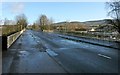
River Leven at Balloch
The River Leven is the primary outflow from Loch Lomond. From here, it flows southwards for approximately 6 miles to join the River Clyde near Dumbarton. This view is from the path beneath Balloch Bridge, looking downstream towards Lomond Bridge.
Image: © David Dixon
Taken: 26 Sep 2019
0.11 miles
9
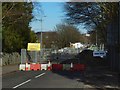
The Lomond Bridge closed
The bridge takes Lomond Road over the River Leven. The sign on the left reads: "A811 Lomond Bridge / Closed for structural strengthening works / Programmed to be complete November 2020". The closure was originally to be for about nine months, but I don't know to what extent this has been affected by the virus-related lockdown that began shortly after this picture was taken.
For views from the sides, see Image and Image
Image: © Lairich Rig
Taken: 20 Mar 2020
0.11 miles
10
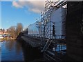
The Lomond Bridge closed
The view is from steps that lead down from the pavement of Lomond Road to the footpath and cycle route alongside the River Leven. This is the northern aspect of the bridge, which is shown from the other side in Image It takes Lomond Road over the river, but it was set to be closed for many months; see Image for comments on its closure.
Image: © Lairich Rig
Taken: 20 Mar 2020
0.11 miles