IMAGES TAKEN NEAR TO
Honeysuckle Lane, ALEXANDRIA, G83 8PL
Introduction
This page details the photographs taken nearby to Honeysuckle Lane, G83 8PL by members of the Geograph project.
The Geograph project started in 2005 with the aim of publishing, organising and preserving representative images for every square kilometre of Great Britain, Ireland and the Isle of Man.

There are currently over 7.5m images from over14,400 individuals and you can help contribute to the project by visiting https://www.geograph.org.uk
Image Map
Images are licensed for reuse under creativecommons.org/licenses/by-sa/2.0
Notes
- Clicking on the map will re-center to the selected point.
- The higher the marker number, the further away the image location is from the centre of the postcode.
Image Listing (91 Images Found)
Images are licensed for reuse under creativecommons.org/licenses/by-sa/2.0
Image
Details
Distance
1
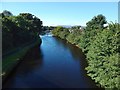
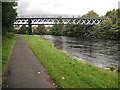
The River Leven
Image: © Lairich Rig
Taken: 6 Sep 2015
0.05 miles
2
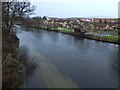
Flooded footpath beside the River Leven
The view is from the western end of Image The area left of centre in the foreground is not normally a part of the river's course, but is a footpath and cycle route. A group of ducks can be seen on it; they included a Image (that picture shows the same pair). The nearest houses on the other side of the river are in the part of Jamestown called Heatherdale Village.
Image: © Lairich Rig
Taken: 16 Jan 2015
0.06 miles
3
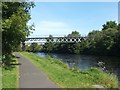
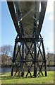
The Stuckie Bridge
This bridge crosses the River Leven, leading from Rosshead to Jamestown. Rosshead is at its western end (on the left in this picture), and Jamestown at its eastern end.
The bridge was originally a viaduct for the Forth and Clyde Junction Railway; it replaced an earlier wooden structure. See Image for a view showing details of the underside.
It is informally known as the Stuckie Bridge; some years ago, that name was explained to me as being the result of an obscure play on words, as follows: it is properly the "Stirling Bridge"; "Stirling" was first altered to "Starling", and then to "Stuckie" (the old Scots name for that bird). This explanation is confirmed by the Vale of Leven website, which provides further information, in an article by Gordon Burns, about the various bridges that cross the Leven: http://www.valeofleven.org.uk/levenbridges.html
For similar views, see Image and Image See Image for a view of the path that now leads over the bridge.
Image: © Lairich Rig
Taken: 22 Aug 2007
0.06 miles
4
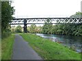
The Stuckie Bridge
The bridge crosses the River Leven, and leads from Rosshead to Jamestown. Rosshead is at its western end (on the left in this picture), and Jamestown at the eastern end.
This was originally a viaduct for the Forth and Clyde Junction Railway; see Image for further details (and for a better picture). See also Image
The end-note on NCN 7 refers to the cycle path that can be seen in the foreground.
Image: © Lairich Rig
Taken: 21 Sep 2008
0.06 miles
5
Footbridge, Jamestown
Footbridge crossing the River Leven.
Image: © Richard Webb
Taken: 1 Sep 2009
0.07 miles
6
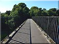
Crossing the Stuckie Bridge
This is the view when crossing from Jamestown to Rosshead; see Image for a view in the opposite direction. See Image for more on the bridge, and for a view of it from the side.
Image: © Lairich Rig
Taken: 6 Sep 2015
0.07 miles
7
The Stuckie Bridge
This former viaduct on the Forth and Clyde Junction Railway now serves as a footbridge from Rosshead (which is on this side of the river) to Jamestown. See Image for a side view, and for further information.
Image: © Lairich Rig
Taken: 19 Apr 2013
0.07 miles
8
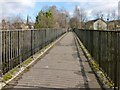
Crossing the Stuckie Bridge
See Image for the description of the bridge, which is a former railway viaduct, and for a view of it from the side.
Relative to that view, the present photograph is a view over the bridge from left to right (west to east), from the Rosshead end to the Jamestown end. The crossing is part of one of the local council's core paths.
See Image for a view across it in the opposite direction.
The spire of Image is visible in the left background.
Image: © Lairich Rig
Taken: 6 Feb 2013
0.07 miles
9

Woods near the Stuckie Bridge
As the 1:25000 map shows, a triangle of woodland is bounded by the approach to Image on the south, and on the other two sides by the River Leven and the lade of one of the works that once stood by the river.
Image: © Lairich Rig
Taken: 30 Sep 2019
0.07 miles
10
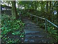
Steps to the Stuckie Bridge
The steps lead from the cycle path to the bridge, both of which features are shown, along with the River Leven, in Image
Image: © Lairich Rig
Taken: 20 Sep 2019
0.07 miles