IMAGES TAKEN NEAR TO
Balloch, ALEXANDRIA, G83 8LX
Introduction
This page details the photographs taken nearby to G83 8LX by members of the Geograph project.
The Geograph project started in 2005 with the aim of publishing, organising and preserving representative images for every square kilometre of Great Britain, Ireland and the Isle of Man.

There are currently over 7.5m images from over14,400 individuals and you can help contribute to the project by visiting https://www.geograph.org.uk
Image Map
Images are licensed for reuse under creativecommons.org/licenses/by-sa/2.0
Notes
- Clicking on the map will re-center to the selected point.
- The higher the marker number, the further away the image location is from the centre of the postcode.
Image Listing (8 Images Found)
Images are licensed for reuse under creativecommons.org/licenses/by-sa/2.0
Image
Details
Distance
1
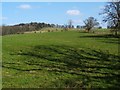
Field at Meikle Boturich
The slopes lead up towards Knockour Hill, the top of which is not visible from here.
Image: © Lairich Rig
Taken: 22 Mar 2012
0.10 miles
2
Road through Boturich Estate
The buildings of Meikle Boturich are in the middle distance, among the trees. The name Boturich, applied to this estate, is stressed on the second syllable: [bɔˈtʌɾɘx], or (a much less precise version without the IPA) "bo-TURR-och".
A variety of spellings can be found in old documents. An unusual one, Butterwick (probably a misguided attempt to construe the name as being formed from English elements), can be seen on a map at the beginning of David Ure's book "General View of the Agriculture in the County of Dumbarton" (1794). The Pont/Blaeu map of the Lennox (based on surveys in the 1580s-90s, and published in 1654) has "Pitturichs", while Roy's Military Survey of Scotland shows the "ruins of Botterich Castle". The present-day Boturich Castle (Image) was built on the same site; see https://canmore.org.uk/site/42486/boturich-castle (at Canmore).
The travelogue book "Scotland Delineated" (1799) mentions, to the south of Loch Lomond, "the castles of Kilmarnock and Batturret, now in ruins"; the first is Kilmaronock (note the crucial extra letter), while the second is, like "Butterwick", a mangled (as opposed to merely old) spelling of Boturich.
In the background, on the left, is a view into Glen Finlas (Image).
Image: © Lairich Rig
Taken: 22 Mar 2012
0.15 miles
3
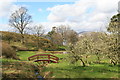
Bridge in Boturich Castle Grounds
View towards Loch Lomond and surrounding hill from the Gardens at Boturich.
Image: © George Rankin
Taken: 11 Apr 2009
0.16 miles
4
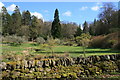
Dry Stane Dyke, and Gardens Boturich
Dry stane (stone) is a building method by which walls are constructed from stones without any mortar to bind them together. Dry stane structures are stable because of their unique construction method and carefully-selected interlocking stones.
Image: © George Rankin
Taken: 11 Apr 2009
0.17 miles
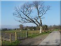
5
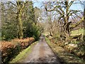
Road through Boturich Estate
This is a continuation of the road shown in Image The present photograph was taken from a point not far to the north of the turning for Boturich Castle.
Image: © Lairich Rig
Taken: 22 Mar 2012
0.17 miles
6
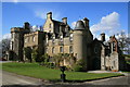
Boturich Castle Loch Lomond
Boturich Castle was built in 1832, on the site of the previous castle. Boturich Castle belonged to the Lennox and Buchanan families originally. In 1850 the Octagon Tower, to the left of the photo was added and became the principal entrance to the castle.
Image: © George Rankin
Taken: 11 Apr 2009
0.17 miles
7
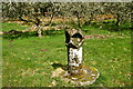
Garden Ornament
An unusual garden ornament in the garden grounds of Boturich Castle, from this angle it looks almost like an owl. On three sides it has the circular cutouts and a hollow on the top, like a bird bath. The back face is square.
Image: © George Rankin
Taken: 11 Apr 2009
0.17 miles
8
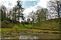
Pond and Castle
View of Boturich Castle and path to the Loch, from the pond at the foot of the Gardens.
Image: © George Rankin
Taken: 11 Apr 2009
0.18 miles