IMAGES TAKEN NEAR TO
McKenzie Drive, ALEXANDRIA, G83 8HL
Introduction
This page details the photographs taken nearby to McKenzie Drive, G83 8HL by members of the Geograph project.
The Geograph project started in 2005 with the aim of publishing, organising and preserving representative images for every square kilometre of Great Britain, Ireland and the Isle of Man.

There are currently over 7.5m images from over14,400 individuals and you can help contribute to the project by visiting https://www.geograph.org.uk
Image Map
Images are licensed for reuse under creativecommons.org/licenses/by-sa/2.0
Notes
- Clicking on the map will re-center to the selected point.
- The higher the marker number, the further away the image location is from the centre of the postcode.
Image Listing (51 Images Found)
Images are licensed for reuse under creativecommons.org/licenses/by-sa/2.0
Image
Details
Distance
1
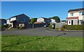
McLean Crescent
It is shown branching off from McKenzie Drive, which is in the foreground. The view is from Lomond Road.
Image: © Lairich Rig
Taken: 20 Sep 2019
0.01 miles
2
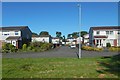
Gallacher Crescent
It is shown branching off from McKenzie Drive. The view is from Lomond Road.
Image: © Lairich Rig
Taken: 20 Sep 2019
0.04 miles
3
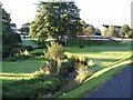
Stream in Balloch
Between Balloch and Mill of Haldane.
Image: © Stephen Sweeney
Taken: 27 Sep 2007
0.06 miles
5
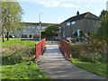
Footbridge over the Ballagan Burn
One of the results of a recent regeneration project was the creation of this footbridge. For a view of the burn from there, see Image As well as this red bridge, there is a blue bridge (just a short distance to the south-west), a network of paths, and various other features (Image, for example).
The parts of the Haldane on the far side of the burn are Shandon Crescent (foreground, right), and Shandon Brae (background, left).
Image: © Lairich Rig
Taken: 19 Oct 2011
0.07 miles
6
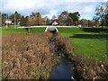
The Ballagan Burn
This is the view upstream from a Image The small bridge ahead carries a road over the burn; it is shown from the other side in Image
Image: © Lairich Rig
Taken: 19 Oct 2011
0.09 miles
7
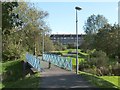
Footbridge over the Ballagan Burn
The bridge was built as part of same regeneration project that created the red Image; see that item for further details. The area of housing in the background is Shandon Crescent in the Haldane.
Only 30 metres to the south of the blue bridge, the Ballagan Burn meets the Carrochan Burn.
Image: © Lairich Rig
Taken: 19 Oct 2011
0.10 miles
8
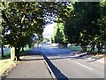
Welcome to Balloch
Approaching Balloch from the east. View down Drymen Road.
Image: © Richard Webb
Taken: 15 Jun 2010
0.10 miles
9
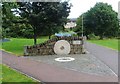
Wall feature incorporating millstone
The inscription to the right of the millstone reads "Mill of Haldane 2005 Community Project". Another inscription, on a nearby stone, explains that the millstones incorporated into this wall feature are "from the last water-operated corn mill in the Vale of Leven"; it also says that the mill was driven by water from Jamestown Dam, and that it was in use until 1942.
The area is called Mill of Haldane on the map, but is generally only referred to locally as the Haldane.
The OS Object Name Books (1890s) describe Mill of Haldane as "a small village having a corn mill, smithy and Toll Bar, the property of William McAlister and occupied by James Craig and others".
Image: © Lairich Rig
Taken: 10 Sep 2010
0.11 miles
10
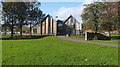
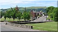
Carrochan (National Park Headquarters)
Carrochan is the headquarters building for the Loch Lomond and the Trossachs National Park Authority. This is an end-on view, from the south-east. For more about the building, and for an earlier picture of it, see Image
The wall that appears in the foreground, on the right, in the present photograph is also shown (from the other side) in Image
Image: © Lairich Rig
Taken: 19 Oct 2011
0.12 miles