IMAGES TAKEN NEAR TO
Stirling Road, ALEXANDRIA, G83 8EP
Introduction
This page details the photographs taken nearby to Stirling Road, G83 8EP by members of the Geograph project.
The Geograph project started in 2005 with the aim of publishing, organising and preserving representative images for every square kilometre of Great Britain, Ireland and the Isle of Man.

There are currently over 7.5m images from over14,400 individuals and you can help contribute to the project by visiting https://www.geograph.org.uk
Image Map
Images are licensed for reuse under creativecommons.org/licenses/by-sa/2.0
Notes
- Clicking on the map will re-center to the selected point.
- The higher the marker number, the further away the image location is from the centre of the postcode.
Image Listing (19 Images Found)
Images are licensed for reuse under creativecommons.org/licenses/by-sa/2.0
Image
Details
Distance
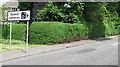
1
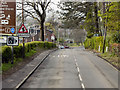
Balloch, Stirling Road
Entering Balloch via the A811, Stirling Road.
Image: © David Dixon
Taken: 19 Apr 2012
0.03 miles
2
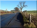
Leaving Balloch by the Stirling Road
A Image heads off to the photographer's right. That picture was taken from the same spot: note that the fence post at the far left in that view is on the right in this one.
Current mapping shows a milestone somewhere ahead, but does not pinpoint its location. It is marked with greater precision on the second-edition map (1897): its position was beside the tall tree that can be seen not far ahead, to the right (east) of the road.
It is no longer present (which is probably why modern mapping is a little vague about where it is); perhaps it was removed because it was viewed as cluttering the pavement, or it may be that it was hit by a vehicle leaving the road.
The same comments apply to the milestone supposedly present almost opposite the start of the Image It was at about Image, on the east side of the road, a mile to the NNE of the spot where the present picture was taken. There is no pavement on that side of the road, but vehicles often travel too fast there, and one of them would have hit the milestone sooner or later.
Image: © Lairich Rig
Taken: 26 Jan 2018
0.08 miles
3
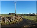
Farm track
The small wooded area in the right background is around the disused quarry that is marked on the map at Image According to map evidence, the quarry and woods were not present in 1860; the quarry was in use in 1898, and was disused by 1914.
The picture was taken from Stirling Road: Image was taken from the same place; note the fence post on the right in that image, which is at the far left in the present picture.
Image: © Lairich Rig
Taken: 26 Jan 2018
0.09 miles
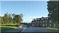
4
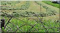
Mown grass
Silage crop awaiting baling and bagging.
Image: © Richard Webb
Taken: 15 Jun 2010
0.11 miles
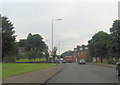
5
Sign, A811
More roadside clutter on the edge of Balloch. There were no fixed cameras on the road at the time of submission, but the vans are a common sight along the road to Stirling.
Usually on this road you will be stuck behind either: a lorry, tractor, scenery braked Micra or a large slow moving cyclist taking photographs for Geograph, so the temptation to speed will not be present.
Image: © Richard Webb
Taken: 15 Jun 2010
0.11 miles
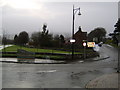
7
A811 junction with Drymen road
A811 becomes Stirling Road beyond this point
Image: © John Firth
Taken: 26 Jul 2012
0.13 miles
8
Entrance to Balloch
From the A811 road from the direction of Stirling.
Image: © Stephen Sweeney
Taken: 31 Jan 2007
0.14 miles
9

Construction site beside Dumbain Road
Seven houses and nineteen flats are to be built on the fenced-off area shown near the centre of the picture; the site is on the northern side of Dumbain Road. See also Image, a closer view about a month later.
Image: © Lairich Rig
Taken: 2 May 2018
0.14 miles
10
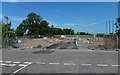
Construction of Dumbain Gardens
Seven houses and nineteen flats would be built here, on the northern side of Dumbain Road. The view is from the junction of Dumbain Road and Manse Drive. See Image for an earlier and more distant view from a different angle.
The finished development would be called Image
Image: © Lairich Rig
Taken: 6 Jun 2018
0.15 miles