IMAGES TAKEN NEAR TO
Dumbain Crescent, ALEXANDRIA, G83 8DW
Introduction
This page details the photographs taken nearby to Dumbain Crescent, G83 8DW by members of the Geograph project.
The Geograph project started in 2005 with the aim of publishing, organising and preserving representative images for every square kilometre of Great Britain, Ireland and the Isle of Man.

There are currently over 7.5m images from over14,400 individuals and you can help contribute to the project by visiting https://www.geograph.org.uk
Image Map
Images are licensed for reuse under creativecommons.org/licenses/by-sa/2.0
Notes
- Clicking on the map will re-center to the selected point.
- The higher the marker number, the further away the image location is from the centre of the postcode.
Image Listing (9 Images Found)
Images are licensed for reuse under creativecommons.org/licenses/by-sa/2.0
Image
Details
Distance
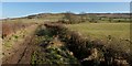
1
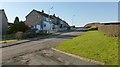
Dumbain Crescent
A footpath from Auchincarroch Road reaches the Haldane here, at Dumbain Crescent. The track in the foreground also provides vehicular access for Image
Image: © Lairich Rig
Taken: 25 Feb 2013
0.07 miles
2
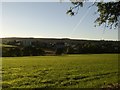
Mill of Haldane from Stirling Road
Just outside Balloch.
Image: © Stephen Sweeney
Taken: 27 Sep 2007
0.10 miles
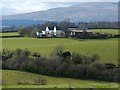
3
Dumbain Farm
Dumbain farm, Mill of Haldane, used to be accessed along the Tinkers loan, so called because a patch of land in the farm was used by travellers as an encampment. Originally owned by the Kippens of Westerton, but the Watsons have been owners since the beginning of the 20th century. Robert Watson who owned and farmed the nearby Wester Auchencarroch in the late 19th century was the only farmer in the Vale of Leven who actually owned his own farm.
Image: © George Rankin
Taken: 25 Jun 2021
0.14 miles
4
Dumbain Farm
This is a fairly distant view, from Auchincarroch Road.
Image: © Lairich Rig
Taken: 30 Mar 2012
0.14 miles
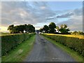
5
Footpath to Auchincarroch Road
This picture was taken from near the end-point of the path at Dumbain Crescent in the Haldane. The distant buildings are: Blairvault, on the right; Image, along the line of the path; and Image, at the far left. Auchincarroch Hill is on the skyline, just left of centre (Image).
(On the variations in spelling, see Image)
Image: © Lairich Rig
Taken: 25 Feb 2013
0.19 miles
6
Construction of Dumbain Gardens
Seven houses and nineteen flats would be built here, on the northern side of Dumbain Road. The view is from the junction of Dumbain Road and Manse Drive. See Image for an earlier and more distant view from a different angle.
The finished development would be called Image
Image: © Lairich Rig
Taken: 6 Jun 2018
0.22 miles
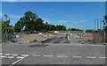
7

Construction site beside Dumbain Road
Seven houses and nineteen flats are to be built on the fenced-off area shown near the centre of the picture; the site is on the northern side of Dumbain Road. See also Image, a closer view about a month later.
Image: © Lairich Rig
Taken: 2 May 2018
0.23 miles
8
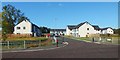
Dumbain Gardens
The houses were built only recently, as is shown by comparison with Image, taken in mid-2018 from almost the same place.
Image: © Lairich Rig
Taken: 20 Sep 2019
0.23 miles
9

Footpath to Dumbain Crescent
The path is marked on the 1:25000 map. This part of it is just north of a crossing of the Carrochan Burn, which is behind the photographer. To the right (northeast) of the path is a smaller tributary burn.
Image: © Lairich Rig
Taken: 2 May 2018
0.24 miles