IMAGES TAKEN NEAR TO
Hardie Street, ALEXANDRIA, G83 0RX
Introduction
This page details the photographs taken nearby to Hardie Street, G83 0RX by members of the Geograph project.
The Geograph project started in 2005 with the aim of publishing, organising and preserving representative images for every square kilometre of Great Britain, Ireland and the Isle of Man.

There are currently over 7.5m images from over14,400 individuals and you can help contribute to the project by visiting https://www.geograph.org.uk
Image Map
Images are licensed for reuse under creativecommons.org/licenses/by-sa/2.0
Notes
- Clicking on the map will re-center to the selected point.
- The higher the marker number, the further away the image location is from the centre of the postcode.
Image Listing (77 Images Found)
Images are licensed for reuse under creativecommons.org/licenses/by-sa/2.0
Image
Details
Distance
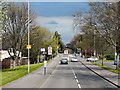
1
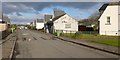
Hardie Street, Levenvale
The street is named after Keir Hardie; compare Image
Part of snow-covered Ben Lomond (Image) can be seen in the background.
Image: © Lairich Rig
Taken: 6 Feb 2013
0.01 miles
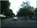
2
Lansbury Street, Levenvale
The street is named after George Lansbury; compare Image The present picture was taken from the junction with Image
Compare the background of Image, which runs parallel to this one.
Image: © Lairich Rig
Taken: 6 Feb 2013
0.04 miles
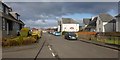
3
Engels Street, Levenvale
The street is named after Friedrich Engels, continuing a political theme that is evident in other street-names nearby: for example, the picture was taken from the junction with Image, and, not far ahead, the street is crossed by Image
It ends at Burns Street, which is adjacent and parallel to the railway line at the eastern edge of Levenvale: see Image, which shows Burns Street.
Image: © Lairich Rig
Taken: 6 Feb 2013
0.08 miles
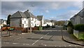
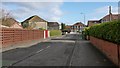
4
Muir Street, Levenvale
As noted in Image, most of the streets in Levenvale are named after political figures. Not far ahead, on the right, is the junction with Image (Keir Hardie); beyond that, the street ends where it meets Image (George Lansbury).
See Image for another example.
The reference in the name Muir Street is less obvious, but, according to http://www.valeofleven.org.uk/scottishplacenames/Mvale_names2.html (Vale of Leven website) it commemorates Thomas Muir of Huntershill; see that link for details.
Image: © Lairich Rig
Taken: 6 Feb 2013
0.09 miles
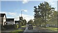
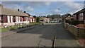
5
Lomond Drive, Levenvale
This road is the western entrance into the Levenvale area.
Levenvale and Tullichewan (an area of housing on the other side of Luss Road) together make up much of this grid square, so I have included several representative views (compare Image).
Apart from a few exceptions like Lomond Road and Lomond Drive (shown here), Argyll/Argyle Avenue (named after Image), and Burns Street, all of which are on the edges of Levenvale, many of the streets in this area are named after political figures: see Image for several examples.
Image: © Lairich Rig
Taken: 6 Feb 2013
0.13 miles
6
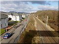
The railway line at Levenvale
The photograph was taken from a Image; its shadow is in the right foreground. Burns Street, which forms the eastern edge of Levenvale, is to the left of the line. The dog-walker is passing Wilkie Place, a block that is set back slightly from Burns street.
Not far beyond this point, after passing Levenvale, the railway line now terminates at Balloch Station, although it used to go further.
[It used to go as far as Balloch Pier Station (now gone), beside Loch Lomond. The present-day Balloch Station building did not then exist; the Balloch Central Station of that day now serves as Image, and the level crossing that was next to it has also been removed.]
The area visible to the right of the line is Fishers Wood; on that side, the footbridge leads to the northern end of Rosshead. See Image for a view of it from the other side.
Image: © Lairich Rig
Taken: 6 Feb 2013
0.14 miles
7
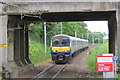
Train Approaching Balloch Railway Station
Until 1986 the service would have continued the short distance to Balloch Pier station via Balloch Central. Balloch Pier station was closed since the connecting steamer service on Loch Lomond had ceased to run in 1981. The line was cut back to Balloch Central, then in 1988 a replacement station - the current Balloch station - was built due South of the central station to avoid having to cross the main road and allow the closure of the level crossing. The original Balloch Central station building is now a Tourist Information Centre.
Image: © David Robinson
Taken: 3 Jun 2017
0.14 miles