IMAGES TAKEN NEAR TO
Halkett Crescent, ALEXANDRIA, G83 0QY
Introduction
This page details the photographs taken nearby to Halkett Crescent, G83 0QY by members of the Geograph project.
The Geograph project started in 2005 with the aim of publishing, organising and preserving representative images for every square kilometre of Great Britain, Ireland and the Isle of Man.

There are currently over 7.5m images from over14,400 individuals and you can help contribute to the project by visiting https://www.geograph.org.uk
Image Map
Images are licensed for reuse under creativecommons.org/licenses/by-sa/2.0
Notes
- Clicking on the map will re-center to the selected point.
- The higher the marker number, the further away the image location is from the centre of the postcode.
Image Listing (61 Images Found)
Images are licensed for reuse under creativecommons.org/licenses/by-sa/2.0
Image
Details
Distance
1
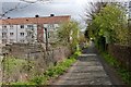
Path in Rosshead
This path leads, though not directly, to the riverside.
Image: © Lairich Rig
Taken: 26 Apr 2013
0.05 miles
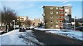
2
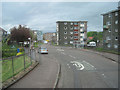
Colquhoun Drive from Heather Avenue
Heading into Jamestown taken from close to railway bridge
Image: © John Firth
Taken: 10 May 2011
0.09 miles
3
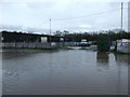
Lomond Industrial Estate
Behind the photographer's position is a lade. On the far side of the industrial estate is the River Leven.
In the foreground, Strone Road is flooded; compare Image, which shows the same area, from a different angle, in drier conditions. The building that appears on the left in the present picture is clearly the same one as is shown in the other view, although a lamp post has been removed since then, and some site safety notices added.
Image: © Lairich Rig
Taken: 3 Jan 2016
0.10 miles
4
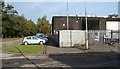
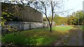
Lomond Industrial Estate
The estate also includes Image and Image, but the present photograph shows some of the buildings at its northern end.
Strone Road, lined by trees, is visible on the left.
The other road, in the foreground, leads to a path on the other side of the buildings: Image
Image: © Lairich Rig
Taken: 25 Oct 2010
0.10 miles
5
Colquhoun Drive, Rosshead
Colquhoun Drive leads directly ahead. Branching off to the right, in front of the tower block, is Halkett Crescent.
For a view from further ahead, taken on the same day, see Image; that item also includes some thoughts (of my own) about the name Rosshead.
Image: © Lairich Rig
Taken: 29 Nov 2010
0.10 miles
6
Lomond Industrial Estate
For further information see Image
The present photograph was taken at the northern end of the estate, from a path between the estate and a stone wall. The wall, shown in Image, separates the estate from a cycle route that follows the western side of the River Leven.
Image: © Lairich Rig
Taken: 25 Oct 2010
0.11 miles
7
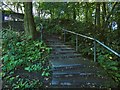
Steps to the Stuckie Bridge
The steps lead from the cycle path to the bridge, both of which features are shown, along with the River Leven, in Image
Image: © Lairich Rig
Taken: 20 Sep 2019
0.12 miles
8
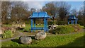
Landscaped area at Rosshead
The top of these structures can be seen over a hedge in the right background of another photograph Image; see that picture for context.
The path shown in that picture is just behind the hedge that is in the background of the present photograph. This area is at Image
Image: © Lairich Rig
Taken: 6 Feb 2013
0.12 miles
9
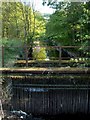
The lade near Rosshead
The lade draws water from the River Leven by means of the Image; see that item for further details. The present photograph was taken from near that point. See Image for a less obstructed view from further ahead.
This is just one of several lades along the course of the River Leven.
Image: © Lairich Rig
Taken: 2 May 2011
0.13 miles
10
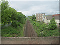
Rails to Balloch
Railway line to Balloch from Heather Avenue overbridge
Image: © John Firth
Taken: 10 May 2011
0.13 miles