IMAGES TAKEN NEAR TO
India Street, ALEXANDRIA, G83 0PL
Introduction
This page details the photographs taken nearby to India Street, G83 0PL by members of the Geograph project.
The Geograph project started in 2005 with the aim of publishing, organising and preserving representative images for every square kilometre of Great Britain, Ireland and the Isle of Man.

There are currently over 7.5m images from over14,400 individuals and you can help contribute to the project by visiting https://www.geograph.org.uk
Image Map
Images are licensed for reuse under creativecommons.org/licenses/by-sa/2.0
Notes
- Clicking on the map will re-center to the selected point.
- The higher the marker number, the further away the image location is from the centre of the postcode.
Image Listing (98 Images Found)
Images are licensed for reuse under creativecommons.org/licenses/by-sa/2.0
Image
Details
Distance
1
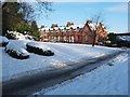
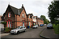
India Street, Alexandria
For earlier photographs, taken by another contributor, see Image and Image As noted in the first of those items, this housing was built for workers in the neighbouring print and dye works, on which, see Image
See http://www.valeofleven.org.uk/indiastreet.html (at the Vale of Leven website) for an article that explains the connection with India, and which provides more information on the industry that was carried on here. That article also includes a picture of Red Row, which preceded India Street.
The booklet "The Old Vale and the New" (Jones/Hopner, 1981) contains a photograph of "Linnbrane, Alexandria c.1963"; it mentions India Street, and adds that "an ancient terrace called 'Red Row' was demolished in 1891 to make way for these eight new sandstone terraced houses".
Also visible in that photograph is a line of buildings which occupied the roadside, now empty, shown in the lower-right part of my photograph. This was Linnbrane Terrace; there were also some houses on the facing side of the road (the near left, in my photograph); the booklet notes that all of these buildings were torn down in 1976.
Image: © Lairich Rig
Taken: 29 Nov 2010
0.01 miles
2
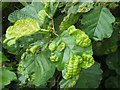
Leaf galls on common alder
This common alder (Alnus glutinosa), which was situated beside the River Leven, had a large number of these blisters or pouches on its leaves, possibly caused by a fungus, Taphrina tosquinetii.
Image: © Lairich Rig
Taken: 19 Sep 2008
0.02 miles
3
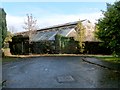
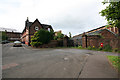
Remnants of the Alexandria Works
The first-edition OS map (surveyed in 1860) shows the Croftengea Print Works in this general area, although the large buildings shown here were not yet present. These works later merged with the Levenfield Works, which were just to the north, to form the Alexandria Works.
The equivalent OS map surveyed c.1897 shows this site as "Alexandria Works (Printing and Dyeing)", and the buildings shown in this view were then present. Because of the surrounding wall, they cannot be seen very well other than from a distance, as in a view of Image For another view of the blocked-up old entrance in front of the buildings, see Image
The present picture was taken from near the southern end of Image (Image).
Image: © Lairich Rig
Taken: 2 Nov 2012
0.03 miles
4
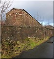
Remnants of the Alexandria Works
These buildings were part of the Alexandria Works (Printing and Dyeing). See Image for further details, and for a view from a different angle. The present photograph was taken from the footpath and cycle route on the western side of the River Leven.
Image: © Lairich Rig
Taken: 1 Jan 2013
0.03 miles
5
India Street Alexandria
What's left of housing for Turkey Red Dye works India Street Alexandria
Image: © Eddie Mackinnon
Taken: 11 Jul 2006
0.03 miles
6
Turkey Red Dye Works Gates Alexandria
India street and Turkey Red Dye Works Gates Alexandria
Image: © Eddie Mackinnon
Taken: 11 Jul 2006
0.03 miles
7
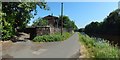
River Leven and former Alexandria Works
The riverside path is part of cycle route NCN 7. To its left are Image (Image / Image).
See Image for a view in the opposite direction from about the same place.
Image: © Lairich Rig
Taken: 6 Jun 2018
0.04 miles
8
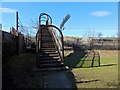
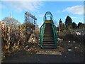
Footbridge over the railway line
On the far side of the bridge (Image), and continuing in the same direction, is North Street, Alexandria: Image
On this side, behind the photographer, is the northern end of India Street (the end that is nearest the photographer's position in Image).
Also behind the photographer, and separated from India Street by some bollards, is the start of a road that leads past the bonded warehouses of Image and the entrance of Image (Image / Image) before meeting Bowie Road.
For that road, see Image (a view to the right from the point from which the present picture was taken), and Image
Image: © Lairich Rig
Taken: 7 Mar 2016
0.04 miles
9
Footbridge over the railway line
On this side, North Street leads to the foot of the steps; see Image, a view back from the top of these steps.
The other side is shown in Image On that side, a road (Image) leads, depending on the direction chosen, either to India Street or to Antartex and Loch Lomond Distillery: Image / Image / Image
Image: © Lairich Rig
Taken: 19 Nov 2020
0.05 miles
10
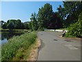
Beside the River Leven
For a view in the opposite direction from about the same place, see Image
In the foreground there is a small car park and the part of the River Leven near Image In front of the houses in the left background is the raised line of the railway. There are some pedestrian tunnels below that line.
Image: © Lairich Rig
Taken: 6 Jun 2018
0.06 miles