
IMAGES TAKEN NEAR TO
Middleton Street, ALEXANDRIA, G83 0DQ
Introduction
This page details the photographs taken nearby to Middleton Street, G83 0DQ by members of the Geograph project.
The Geograph project started in 2005 with the aim of publishing, organising and preserving representative images for every square kilometre of Great Britain, Ireland and the Isle of Man.

There are currently over 7.5m images from over14,400 individuals and you can help contribute to the project by visiting https://www.geograph.org.uk
Image Map
Images are licensed for reuse under creativecommons.org/licenses/by-sa/2.0
Notes
- Clicking on the map will re-center to the selected point.
- The higher the marker number, the further away the image location is from the centre of the postcode.
Image Listing (122 Images Found)
Images are licensed for reuse under creativecommons.org/licenses/by-sa/2.0
Image
Details
Distance
1
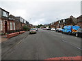
Middleton Street in Alexandria
Looking north-westward.
Image: © Peter Wood
Taken: 25 Jul 2020
0.01 miles
2
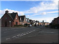
Middleton Street Alexandria
taken looking south at the junction of Gilmour street and Middleton street
Image: © Eddie Mackinnon
Taken: 1 Apr 2006
0.05 miles
3
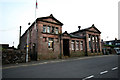
Gilmour Institute Alexandria
Gilmour Institute Alexandria now library
Image: © Eddie Mackinnon
Taken: 3 Jul 2006
0.05 miles
4
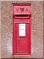
Victorian Postbox
This postbox is located at the junction of Middleton Street and Overtoun Street.
(More precisely, a house stands at the SW corner of the crossroads; the postbox is set into its north-facing wall, only inches from the NE corner of the house.)
Image: © Lairich Rig
Taken: 14 Nov 2008
0.06 miles
5
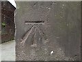
Bench mark on the Gilmour Institute
For the whole building, see Image In relation to that picture, this bench mark is on the near left corner of the building, on the side of the corner that faces the street. I looked for this mark after consulting OS records, rather than noticing it by chance. According to the Ordnance Survey's own database, this is a 3rd-order cut bench mark, 22.450 metres above Newlyn Datum.
Image: © Lairich Rig
Taken: 8 Jun 2018
0.06 miles
6
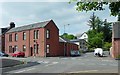
Former drill hall, Overton Road
The picture shows the junction of Middleton Street (running from left to right) and Overton Road (entering at the lower left corner of the picture). The building at the corner opposite the photographer's position is labelled a "drill hall" on the 1:2500 OS map revision of c.1914. See https://canmore.org.uk/site/332996/alexandria-1-5-overton-street-drill-hall (at Canmore) for further details of its use then, and its subsequent conversion. Canmore describes the building as having a two-storey front with a single-storey section behind; those features are evident in the picture.
Another contributor's article lists this and other buildings that were employed as drill halls during the First World War: http://www.geograph.org.uk/article/WW1-Great-War-Centenary---Drill-Halls
Image: © Lairich Rig
Taken: 30 May 2014
0.06 miles
7
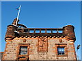
Masonic Temple: detail
See Image for the main description. The features shown in the present photograph are located above the main entrance.
For a closer look at the carved foliage, see Image Click on the end-note title for other images of the building.
Image: © Lairich Rig
Taken: 30 Nov 2010
0.06 miles
8
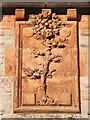
Masonic Temple: detail
See Image for the main description of the building as a whole, and Image for a wider view of the area in which the detail shown in the present photograph occurs.
Around the foliage, it is possible to make out the vestiges of some lettering ("VALE", "[S]COTCH", "[GI]RLS" and "[S]OCIETY", referring to the Scotch Girls' Friendly Society); the building was originally designated an Institute for Working Girls, complementing the men-only Image nearby.
Click on the end-note title for other pictures of the building.
Image: © Lairich Rig
Taken: 30 Nov 2010
0.06 miles
9
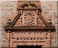
Masonic Temple: detail
See Image for the main description, and for the whole building. The present picture shows details above the main entrance (on the southern side). At the top is the Gilmour crest and motto: "Nil penna sed usus" ("not the pen, but its use"); below that are details relating to use of the building as a Masonic Temple from 1921 onwards:
"Lodge Bonhill and Alexandria
St Andrew's Royal Arch
1826—1921
Masonic Temple № 321."
Click on the end-note title for other pictures.
Image: © Lairich Rig
Taken: 5 Apr 2013
0.06 miles
10
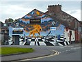
The Pawn Lounge mural
The mural had only recently been painted when this picture was taken. It is by Barry the Cat, who had recently painted the nearby Image
The building is on Overton Street (part of which is visible in the foreground), which becomes Overton Road beyond the next junction.
Image: © Lairich Rig
Taken: 5 Aug 2016
0.07 miles