IMAGES TAKEN NEAR TO
Main Street, ALEXANDRIA, G83 0BH
Introduction
This page details the photographs taken nearby to Main Street, G83 0BH by members of the Geograph project.
The Geograph project started in 2005 with the aim of publishing, organising and preserving representative images for every square kilometre of Great Britain, Ireland and the Isle of Man.

There are currently over 7.5m images from over14,400 individuals and you can help contribute to the project by visiting https://www.geograph.org.uk
Image Map
Images are licensed for reuse under creativecommons.org/licenses/by-sa/2.0
Notes
- Clicking on the map will re-center to the selected point.
- The higher the marker number, the further away the image location is from the centre of the postcode.
Image Listing (107 Images Found)
Images are licensed for reuse under creativecommons.org/licenses/by-sa/2.0
Image
Details
Distance
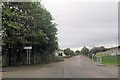
1

Turnbull Avenue, Burnbrae
For the family commemorated by this street name, see the "Turnbull" entries at http://www.valeofleven.org.uk/scottishplacenames/Tvale_names.html (Vale of Leven website).
For a view from further along the road, see Image
The present photograph was taken from the southern end of Turnbull Avenue, at a corner; on the other side of the corner (out of shot to the left) the road becomes Image See Image for a more distant view showing both streets.
Image: © Lairich Rig
Taken: 30 Nov 2010
0.04 miles
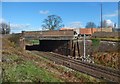
3
Turnbull Avenue, Burnbrae
The view is from further along the road that is shown in Image At the far right is a railway bridge: Image
Image: © Lairich Rig
Taken: 2 Apr 2017
0.08 miles
4
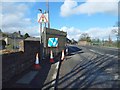
Damaged bridge at Burnbrae, Alexandria
The bridge takes Main Street, Alexandria, over the railway line.
A week before this picture was taken, a vehicle hit the left (west) parapet of the bridge; the resulting gap in the stonework has been covered by boards.
The damage was soon repaired: Image
For a view of the damaged bridge from the side, see Image
Image: © Lairich Rig
Taken: 19 Mar 2017
0.08 miles
5
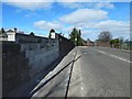
Repaired bridge at Burnbrae, Alexandria
The damage shown in Image was soon repaired. See that picture for more information.
Image: © Lairich Rig
Taken: 2 Apr 2017
0.08 miles
6
Damaged bridge at Burnbrae, Alexandria
The bridge carries Main Street, Alexandria, over the railway line. Seven days before this picture was taken, a vehicle hit the parapet on the near side of the bridge, causing the damage shown here. For a view across the bridge, on the same day as the present picture, see Image
On the day of the accident, I crossed the bridge as a pedestrian, but it was closed to vehicles while its structural integrity was being checked.
The damage was soon repaired: Image
The grassy area visible through the tunnel is part of the grounds of the Image; that earlier picture, a view in roughly the same direction, was taken from the bridge.
The present picture is a view from Image
Image: © Lairich Rig
Taken: 19 Mar 2017
0.08 miles
7
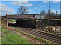
Repaired bridge at Burnbrae, Alexandria
The damage shown in Image was soon repaired. See that picture for more information.
Image: © Lairich Rig
Taken: 2 Apr 2017
0.08 miles
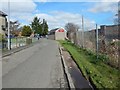
8

Hillside Avenue, Burnbrae
The photograph was taken from the southern end of the street, which is visible from a distance in the left-hand side of Image; the route shown there continues along this street until the junction with Image
Previous: Image
Next: Image
Image: © Lairich Rig
Taken: 30 Nov 2010
0.08 miles
9
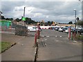
Vale of Leven Academy
The car park and demolition site which was the previous school building. The school has moved to a new building just to the east, on the site of its playing field (seen as a blaes pitch on the aerial photos).
View of the old buildings: Image
Image: © Richard Webb
Taken: 1 Sep 2009
0.09 miles
10
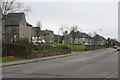
Allan Crescent Alexandria
Allen Crescent taken from the Place of Bonhill
Image: © Eddie Mackinnon
Taken: 15 Apr 2006
0.10 miles