IMAGES TAKEN NEAR TO
Hawthornhill Road, DUMBARTON, G82 5JF
Introduction
This page details the photographs taken nearby to Hawthornhill Road, G82 5JF by members of the Geograph project.
The Geograph project started in 2005 with the aim of publishing, organising and preserving representative images for every square kilometre of Great Britain, Ireland and the Isle of Man.

There are currently over 7.5m images from over14,400 individuals and you can help contribute to the project by visiting https://www.geograph.org.uk
Image Map
Images are licensed for reuse under creativecommons.org/licenses/by-sa/2.0
Notes
- Clicking on the map will re-center to the selected point.
- The higher the marker number, the further away the image location is from the centre of the postcode.
Image Listing (87 Images Found)
Images are licensed for reuse under creativecommons.org/licenses/by-sa/2.0
Image
Details
Distance
1
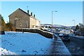
Hawthornhill Road, Castlehill
This part of the road is just to the north of Image and Image (see also Image).
For other parts of the road, see Image and Image
Image: © Lairich Rig
Taken: 24 Dec 2010
0.04 miles
2
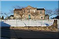
Dumbarton Joint Hospital
The building (also shown in Image) stands on the northern side of Image, which is visible in the foreground.
"Originally a Fever and Infectious Diseases hospital, the County Hospital (now called 'Dumbarton Joint') replaced the former Combination Hospital". The main building "opened in 1894 at a cost of around £20,000. It occupied a five acre site, then outside the burgh boundary."
[The above information is from the booklet "Old Dumbarton" (John Hood, 1999), which provides additional details.]
Image: © Lairich Rig
Taken: 24 Dec 2010
0.09 miles
3
Dumbarton Joint Hospital
See Image for another view, and for further information.
With reference to the present picture: until recently, a lodge (now demolished) stood beside the large sign on the left.
Image: © Lairich Rig
Taken: 9 Aug 2013
0.09 miles
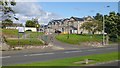
4
Cleared site of the former OLSP
Demolition of Image is complete, and the ground has been cleared.
Image: © Lairich Rig
Taken: 27 Feb 2019
0.09 miles
5

Cleared site of the former OLSP
Demolition of Image is complete, and the ground has been cleared.
Image: © Lairich Rig
Taken: 27 Feb 2019
0.09 miles
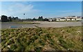
6
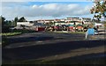
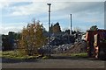
Demolition of the former OLSP
The main building has been reduced to rubble: Image The standing building, with tall chimney, is centred on Image
Image: © Lairich Rig
Taken: 19 Oct 2018
0.10 miles
7
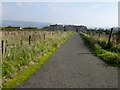
Path near Knowetop Farm
Image itself has now closed. The houses visible ahead are at the top of Castlehill. The path, if followed in the opposite direction, meets a Image
The two peaks of Dumbarton Rock are visible at the far right.
Image: © Lairich Rig
Taken: 28 Sep 2013
0.10 miles
8
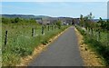
Path to Castlehill Road
The houses not far ahead, where the path ends, are on Castlehill Road. For a view back from there, see Image
Image: © Lairich Rig
Taken: 29 May 2020
0.10 miles
9
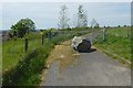
Path from Castlehill Road
It meets up with the Hawthornhill-to-Dalmoak route — https://www.geograph.org.uk/snippet/4594 — but is not part of it. See Image for a view back to the gate from further ahead.
Image: © Lairich Rig
Taken: 29 May 2020
0.10 miles
10
Rubble at the former OLSP site
See Image for a view from the south, and for context. The present picture is a view from the eastern perimeter.
Image: © Lairich Rig
Taken: 19 Oct 2018
0.10 miles