IMAGES TAKEN NEAR TO
Cardross, DUMBARTON, G82 5HQ
Introduction
This page details the photographs taken nearby to G82 5HQ by members of the Geograph project.
The Geograph project started in 2005 with the aim of publishing, organising and preserving representative images for every square kilometre of Great Britain, Ireland and the Isle of Man.

There are currently over 7.5m images from over14,400 individuals and you can help contribute to the project by visiting https://www.geograph.org.uk
Image Map
Images are licensed for reuse under creativecommons.org/licenses/by-sa/2.0
Notes
- Clicking on the map will re-center to the selected point.
- The higher the marker number, the further away the image location is from the centre of the postcode.
Image Listing (15 Images Found)
Images are licensed for reuse under creativecommons.org/licenses/by-sa/2.0
Image
Details
Distance
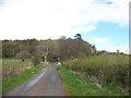
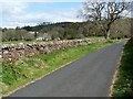
1
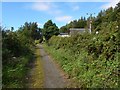
Approaching Red Road
The view is from further along the path shown in Image The path passes Knowhead before reaching Image
Image: © Lairich Rig
Taken: 29 Aug 2016
0.02 miles
2
Red Road
The building nearest the road is West Lodge. To the right is Knowehead, with East Lodge behind it.
See also Image and Image
Image: © Lairich Rig
Taken: 17 Apr 2009
0.03 miles
3
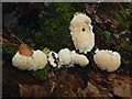
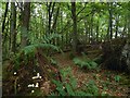
Fungus in Lyleston Wood
See Image for context; this particular group of fruiting bodies can be seen in that picture.
At the time of submission, I have not determined the species. Though I did come across a picture of the same species online, it was in a stock photo that was wrongly captioned (as seems often to be the case with stock photos) as being of a slime mould, which it certainly is not.
The fungal fruiting bodies are not quite hairy, nor are they spiny like some puffballs; instead, the surface texture, when seen close-up, was more akin to that shown in Image (a picture of a different species), with fringed teeth. As for the droplets, it is possible that they were exuded by the fungus (in a process that is called guttation), but they may just be raindrops.
Image: © Lairich Rig
Taken: 28 Sep 2018
0.06 miles
4
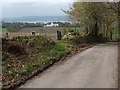
Gate beside Red Road
The field on the other side of the gate was being ploughed when I took this photograph.
The prominent white building with the green roof is Cardross Crematorium ( http://www.geograph.org.uk/photo/433686 ). The River Clyde is visible behind it, and, further yet, the town of Port Glasgow can be seen on the far shore.
Image: © Lairich Rig
Taken: 17 Apr 2009
0.07 miles
5
Lyleston Wood
The wood is shown and named on the 1:25000 and 1:50000 maps. The pale blobs in the left foreground are a kind of fungus: Image
Image: © Lairich Rig
Taken: 28 Sep 2018
0.07 miles
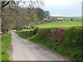
7
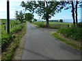
Red Road at West Lodge
The path shown in Image meets Red Road beside West Lodge. The present picture is a view of the road from that point, which is the western end of the core path.
Red Road itself leads downhill to meet the main road at Image, almost opposite the point (Image) where a road leads down to Ardmore Point.
Ardmore Point itself can be seen in this picture, just right of centre, as a wooded promontory, projecting out into the Firth of Clyde.
Image: © Lairich Rig
Taken: 3 Jun 2016
0.10 miles
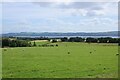
8
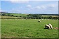
Grazing sheep
Seen from Red Road.
Image: © Richard Sutcliffe
Taken: 30 Jul 2024
0.11 miles
9
Red Road
The nearest building on the left is Lyleston, with Keppoch Cottages behind and to the left of it. Compare Image
Image: © Lairich Rig
Taken: 13 Apr 2012
0.14 miles
10
Field with sheep
Looking towards the Clyde.
Image: © Richard Sutcliffe
Taken: 30 Jul 2024
0.15 miles