IMAGES TAKEN NEAR TO
John Street, DUMBARTON, G82 4QY
Introduction
This page details the photographs taken nearby to John Street, G82 4QY by members of the Geograph project.
The Geograph project started in 2005 with the aim of publishing, organising and preserving representative images for every square kilometre of Great Britain, Ireland and the Isle of Man.

There are currently over 7.5m images from over14,400 individuals and you can help contribute to the project by visiting https://www.geograph.org.uk
Image Map
Images are licensed for reuse under creativecommons.org/licenses/by-sa/2.0
Notes
- Clicking on the map will re-center to the selected point.
- The higher the marker number, the further away the image location is from the centre of the postcode.
Image Listing (208 Images Found)
Images are licensed for reuse under creativecommons.org/licenses/by-sa/2.0
Image
Details
Distance
1
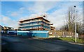
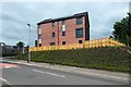
New development, John Street, Renton
John Street is in the foreground. On the right is a cycle path / footpath that runs alongside the lade intake here at Dalquhurn: Image / Image The existing houses at the far left are on Martin Gannon Court.
The new development will consist of one- and two-bedroom flats and two-bedroom houses. The development site straddles the OS grid line, but its nearer parts are in the OS square from which the picture was taken.
For later views, see Image and Image
Image: © Lairich Rig
Taken: 4 Jan 2016
0.01 miles
2
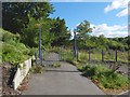
National Cycle Network gates
West of the River Leven, south of Renton. (I felt temporarily quite lost here, having thought I was about 0.6 km SSE of this point and suddenly finding myself in an off-map bran'-new housing estate ... as always, things sorted themselves out, and I am now quite confident about the placing of this image.)
(Yeah, as if! ... fingers crossed and just waiting for correction!!)
Image: © Barbara Carr
Taken: 21 Apr 2013
0.02 miles
3
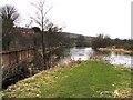
The Lade at Dalquhurn Renton
River Leven and Dalquhurn Works Lade
Image: © Eddie Mackinnon
Taken: 10 Apr 2006
0.02 miles
4
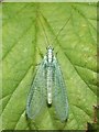
A Green Lacewing (Chrysopa perla)
This is not the only species of Green Lacewing in Britain; there are about 18 species, some of which can be difficult to identify without a detailed examination. However, Chrysopa perla has very distinctive head markings [see e.g. "Collins Complete British Insects" by Michael Chinery].
Green Lacewings are sometimes referred to as "golden-eyes"; in fact, the genus name Chrysopa comes from the Greek "chrūsōpos", which means "with golden eyes [or face]".
This photograph was taken in the evening; the insect was resting on some bushes near a riverside footpath.
Image: © Lairich Rig
Taken: 23 May 2007
0.02 miles
5
National Cycle Network gates
Another contributor's earlier picture shows them in a different season (and, yes, correctly located): Image
This short section of cycle path runs alongside a lade intake (the lade was associated with the Dalquhurn Works, now gone and replaced by modern housing), and soon meets up with the main cycle path that follows the western bank of the River Leven.
The gates are shown from further away in Image, and, from the other side, in Image
Image: © Lairich Rig
Taken: 29 Aug 2016
0.02 miles
6
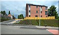
New development, John Street, Renton
The building is shown under construction in Image, and from a different angle in Image The outer shell, at least, appears to be complete.
Image: © Lairich Rig
Taken: 8 Aug 2016
0.02 miles
7
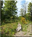
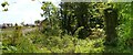
Former course of railway line (Dalquhurn Works)
From a railway line that followed the western bank of the River Leven, and which served the works at Dalquhurn and Cordale Point, a branch led into the heart of the Dalquhurn Dye Works. The course of that line roughly corresponds with that of the curving concrete structure that is shown here, and which was probably associated with that line.
For further information, and for context, see Image, a view along the same structure in the opposite direction. See also Image
Image: © Lairich Rig
Taken: 21 May 2012
0.02 miles
8
New development, John Street, Renton
The development is shown under construction in Image, and from a different angle in Image It straddles the OS grid line, so that, in each case, at least part of the development is in the same grid square as the photographer.
Image: © Lairich Rig
Taken: 8 Aug 2016
0.02 miles
9
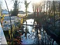
The lade at Dalquhurn
The intake of the lade is shown here: Image (that photo was taken only a few metres away from this one, and parts of the same metal bridge are visible in both images, and in Image).
The lade was created for the dyeing industry that used to flourish in this area; specifically, it was built for Dalquhurn Dye Works. In this photograph, the direction of flow is away from the photographer's position. As the most notable such feature in the area, it is simply referred to locally as "the Lade".
This part of the lade has always been exposed to view. However, at the time this photo was taken, another section that had long been covered had only recently been exposed as a result of demolition work: Image It is being kept open as a feature of the housing development at that site; see Image
Image: © Lairich Rig
Taken: 3 Dec 2008
0.02 miles
10
Old gatepost at Dalquhurn
The upright structure on the right is now covered in vegetation, but it appears to be an old gatepost. This picture was taken at the north-eastern corner of Dalquhurn. About 500 metres to the south are some other Image which look fairly similar; the latter were associated with Dalquhurn Dye Works, and they are located at the south-eastern corner of the area associated with those works.
In the foreground, on the left, is what looks like a path; however, it is the former course of a railway branch line that led from the riverside to the dye works: Image For the houses in the background, see Image
Image: © Lairich Rig
Taken: 21 May 2012
0.02 miles