IMAGES TAKEN NEAR TO
Macbride Way, DUMBARTON, G82 4QW
Introduction
This page details the photographs taken nearby to Macbride Way, G82 4QW by members of the Geograph project.
The Geograph project started in 2005 with the aim of publishing, organising and preserving representative images for every square kilometre of Great Britain, Ireland and the Isle of Man.

There are currently over 7.5m images from over14,400 individuals and you can help contribute to the project by visiting https://www.geograph.org.uk
Image Map
Images are licensed for reuse under creativecommons.org/licenses/by-sa/2.0
Notes
- Clicking on the map will re-center to the selected point.
- The higher the marker number, the further away the image location is from the centre of the postcode.
Image Listing (200 Images Found)
Images are licensed for reuse under creativecommons.org/licenses/by-sa/2.0
Image
Details
Distance
1
Demolition site, Dalquhurn
Marked as "works" on the 1:25000 map, now demolished pending renovation.
Image: © Richard Webb
Taken: 1 Sep 2009
0.02 miles
2
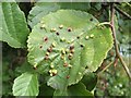
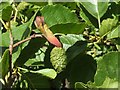
Leaf galls on common alder
(The galls in my photograph are past their best. Compare another example, photographed in a different year, but earlier in the season, which shows more attractive colours: Image)
Two kinds of leaf gall were present in abundance on the native (or common) alder trees (Alnus glutinosa) in this area; both kinds could often be found on the same tree.
The growths shown in this photo are caused by the gall mite Eriophyes laevis, and they are scattered over the upper surface of the leaf; on the underside, there are only small inconspicuous openings. Many leaves were much more densely galled than this, sometimes to the extent that the leaves became quite distorted.
The other variety of gall that was present on these trees is shown here: Image
Image: © Lairich Rig
Taken: 10 Sep 2008
0.03 miles
3
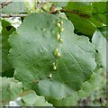
Leaf galls on common alder
Two kinds of leaf gall were present in abundance on the common alder trees (Alnus glutinosa) in this area; both kinds could often be found on the same tree.
Those shown in this photo are caused by the gall mite species Eriophyes inangulis; as the specific part of that name suggests, they grow in the angles between the midrib of the leaf and the side veins. They are about 5 mm long, and, as can be seen, are elongated in the direction of the midrib. On the underside of the leaf, the openings of the galls are quite prominent; they are fringed with brown hairs.
The other variety of gall that was present on these trees is shown here: Image
Image: © Lairich Rig
Taken: 10 Sep 2008
0.03 miles
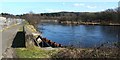
4
Outflow from the former Dalquhurn silk dye works behind Mill Lade
Image: © Mick Garratt
Taken: 26 Aug 2017
0.04 miles
5
Alder tongue gall
This gall, which affects the cone-like female catkins of the common (or native) alder (Alnus glutinosa), is caused by a species of fungus, Taphrina alni. The galls start off greenish, but redden as they age. Taphrina amentorum is sometimes encountered as an older synonym for T. alni.
According to "British Plant Galls" (Redfern/Shirley/Bloxham), this gall was very rare in Britain in the 1940s, when it was known only from Cornwall. Even in recent years, it was not at all common; however, it now seems to be expanding its range rapidly.
The gall shown here is 25mm long, larger than the catkin (15mm high) on which it is growing. This is just one of two locations (both alongside the River Leven) in which, on the day this photo was taken, I happened to notice these galls; about 800 metres upstream, another common alder tree was more densely galled, with up to half a dozen "tongues" per catkin: Image Over the next few weeks, I found that it was in evidence in several other locations along the course of the river; in fact, it now appears to be quite common in this area.
Image: © Lairich Rig
Taken: 24 Jul 2009
0.04 miles
6
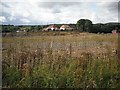
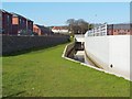
The lade at Dalquhurn
When this picture was taken, a housing development at Dalquhurn, on what was once the site of Dalquhurn Dye Works, was still under construction. A lade that was built for the dye works had long been covered, but is being kept open as a feature of the new development, as shown here.
An equivalent view from about two years earlier shows how the site has changed: Image Note that the houses appearing on the left in that photograph can also be seen in the present photograph.
Image: © Lairich Rig
Taken: 24 Dec 2010
0.04 miles
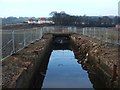
7
The lade at Dalquhurn
The lade originally served the dye-works at Dalquhurn. A housing development has recently been completed here. Compare two earlier photographs to show how the old lade changed during the construction process: Image / Image See also Image
Image: © Lairich Rig
Taken: 27 Mar 2012
0.04 miles
8
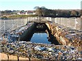
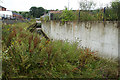
The lade at Dalquhurn
The lade was built for the Dalquhurn Dye Works, which formerly occupied this site.
While the first half of the lade (as reckoned from its intake), has long been exposed (Image), this outflowing half had long been covered by buildings. However, when this picture was taken, the lade was exposed to view as a result of demolition work which had recently cleared the area. It is being kept open as a feature of the new development, as can be seen in an equivalent view, captured two years after the present photograph was taken: Image
The houses in the background are in the Tontine area of Renton, and can also be seen in the later view of the lade (see the last-cited link).
Image: © Lairich Rig
Taken: 3 Dec 2008
0.04 miles
9
Outflow of the lade at Dalquhurn
At this point, water in a lade that used to serve the Dalquhurn Dye Works flows out to rejoin the River Leven. For further information, see Image, which was taken from almost the same spot. The housing development mentioned there is being built behind the fence to the left of the path.
Image: © Lairich Rig
Taken: 24 Mar 2011
0.05 miles
10
The lade at Dalquhurn
By 2018, when this picture was submitted, a new housing development had been built alongside the lade, which was left open: Image Click on the end-note title for other views of the lade at different periods.
Image: © Lairich Rig
Taken: 22 Jan 2010
0.05 miles