IMAGES TAKEN NEAR TO
Station Street, DUMBARTON, G82 4ND
Introduction
This page details the photographs taken nearby to Station Street, G82 4ND by members of the Geograph project.
The Geograph project started in 2005 with the aim of publishing, organising and preserving representative images for every square kilometre of Great Britain, Ireland and the Isle of Man.

There are currently over 7.5m images from over14,400 individuals and you can help contribute to the project by visiting https://www.geograph.org.uk
Image Map
Images are licensed for reuse under creativecommons.org/licenses/by-sa/2.0
Notes
- Clicking on the map will re-center to the selected point.
- The higher the marker number, the further away the image location is from the centre of the postcode.
Image Listing (213 Images Found)
Images are licensed for reuse under creativecommons.org/licenses/by-sa/2.0
Image
Details
Distance
1
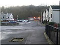
Station Street, Renton
Looking towards the station from just off Main Street.
Image: © Stephen Sweeney
Taken: 6 Dec 2008
0.01 miles
3
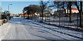
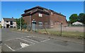
Back Street, Renton
The large building on the right is Image, whose grounds are behind the fence; in the 1970s, it replaced the previous school building, which stood on the site of the present-day school pitch.
The first turning on the left leads into Image
For a view along the same section of the street, but in the opposite direction, see Image See also Image, which was taken from a point further north along the street, looking in the opposite direction.
Image: © Lairich Rig
Taken: 11 Nov 2010
0.03 miles
4
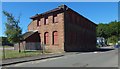
The Annexe
The view is from Station Street. The building is at the corner of Station Street and Back Street. See Image for a different view.
It is a relic of the primary school that preceded the one built in 1975. Before that, it was a secondary school: see the discussion of the Annexe in the end-note.
Image: © Lairich Rig
Taken: 4 Jul 2018
0.03 miles
5
The Annexe
The building is at the corner of Back Street (which is in the foreground) and Station Street. For further information, see the comments on the Annexe in the end-note. In short, it is a relic of the pre-1975 primary school, and it had earlier been a secondary school.
See Image for a view from a different angle.
Image: © Lairich Rig
Taken: 9 Jul 2018
0.03 miles
6
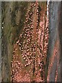
Coral Spot Fungus (Nectria cinnabarina)
At the place where this picture was taken, there is a line of tree stumps on the pavement; the fungi shown here were growing on the side of one of them.
This dense covering of pustules is an example of the so-called "conidial stage" of the fungus Nectria cinnabarina; its coral-pink colour explains the common name of Coral Spot Fungus.
This fungus occurs in dense groups on dead or dying wood - the twigs and branches of (usually) broad-leaved trees - and causes Coral-spot Disease; however, it is not a particularly strong parasite in itself, and its presence on a living plant probably indicates that its host was not in the best of condition to start with.
Another commonly-encountered phase of its life-cycle, the so-called "perithecial stage", is shown on the right-hand side of the following photo: Image As with many similar fungal species, it was not realized at first that the two phases were really the same species, and they were originally assigned different scientific names (in this case, the pink conidial stage was named Tuberculina vulgaris). When subsequent research reveals them to be merely two different stages of the same species, one of the two assigned names has to be discarded.
Image: © Lairich Rig
Taken: 26 Dec 2008
0.03 miles
7
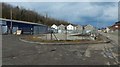
Carman Industrial Estate
The ground at the centre of the image had recently been waste ground (Image), but was now being laid out for storage; specifically, to support large metal storage containers that were set up here later: Image
The fence was replaced soon after the present picture was taken: Image
The houses in the central background are on Station Street. Back Street is on the right. Part of this area is seen, as rough ground, at the far right in an earlier picture: Image
Image: © Lairich Rig
Taken: 14 Apr 2018
0.03 miles
8
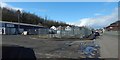
Carman Industrial Estate
The picture was taken about a week after Image The fence was being replaced, as shown here.
Compare Image, taken in April 2011, and showing rough ground here, and Image, taken about six months after the present picture, and showing the storage containers that were set up on the site; by that time, replacement of the original fence was complete.
Image: © Lairich Rig
Taken: 22 Apr 2018
0.03 miles
9
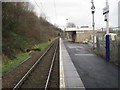
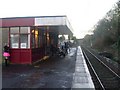
Renton railway station, West Dunbartonshire
Opened in 1850 by the Caledonian and Dunbartonshire Junction Railway in its line from Bowling (on the Clyde) to Balloch Pier (on Loch Lomond). View north towards Alexandria and Balloch. Old photographs show this used to be a two-platform station.
Image: © Nigel Thompson
Taken: 29 Dec 2012
0.03 miles
10
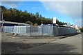
Storage units, Back Street
See Image (an earlier picture) for context, and for how the site was developed from rough ground.
Image: © Lairich Rig
Taken: 6 Oct 2018
0.04 miles