IMAGES TAKEN NEAR TO
Tontine Park, DUMBARTON, G82 4LW
Introduction
This page details the photographs taken nearby to Tontine Park, G82 4LW by members of the Geograph project.
The Geograph project started in 2005 with the aim of publishing, organising and preserving representative images for every square kilometre of Great Britain, Ireland and the Isle of Man.

There are currently over 7.5m images from over14,400 individuals and you can help contribute to the project by visiting https://www.geograph.org.uk
Image Map
Images are licensed for reuse under creativecommons.org/licenses/by-sa/2.0
Notes
- Clicking on the map will re-center to the selected point.
- The higher the marker number, the further away the image location is from the centre of the postcode.
Image Listing (164 Images Found)
Images are licensed for reuse under creativecommons.org/licenses/by-sa/2.0
Image
Details
Distance
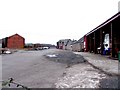
1
Taylor Street, Dalquhurn
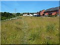
The picture was taken in connection with the Geograph article linked from the end-note, in which I present my research into the location of Pillanflatt Farm, which appears to have been in existence in 1841, but which had disappeared completely when the first OS map of the area was surveyed in 1860.
The two western buildings were located, roughly, in the area between the vehicles (cars and vans) and the two brick-red buildings to their right (north). The annotated satellite view that is also linked from the end-note makes this clear.
For a view in the opposite direction from about that spot, see Image, which explains where the farm's eastern building, probably the farmhouse, was located in relation to present-day features.
The houses here were built in around 2011. The white buildings in the background of the present picture are not part of the same development, but are older houses in the Tontine Park area of Renton.
Image: © Lairich Rig
Taken: 27 Jun 2018
0.05 miles
2
The former site of farm buildings at Pillanflatt
A farm called Pillanflatt disappeared before the earliest OS maps of the area were surveyed, but it does appear on an 1841 plan. My map-based research on its location is presented in an article that is linked from the end-note.
According to that research, the two western buildings at Pillanflatt, as depicted on the 1841 plan, were more or less where the modern-day houses are in the left foreground of this photograph.
See Image for the site of the main farmhouse itself. Both of these sites are on present-day Taylor Street in a recently built housing development at Dalquhurn.
See the article for a full discussion. See also the annotated satellite view that is linked from the end-note; these sites are marked on it.
Image: © Lairich Rig
Taken: 13 Jul 2018
0.05 miles
3
The former site of Pillanflatt farmhouse
According to my map-based research, presented in the article linked from the end-note, the main farmhouse at Pillanflatt was at or near the site of the house that is just left of centre, where what looks like a white car with a magenta roof is parked.
An 1841 plan shows what looks like a courtyard in front of the farmhouse: the position of the courtyard would correspond, roughly, to the present-day road in front of the house.
The 1841 plan shows two other farm buildings to the west of the main farmhouse; for their position, see Image Both that site and the one shown in the present picture are on Taylor Street, in a recently-built housing development at Dalquhurn.
These positions are approximate only (I estimate them to be correct to within 50 metres or so); see the article for a full discussion. See also the annotated satellite view that is linked from the end-note.
Image: © Lairich Rig
Taken: 13 Jul 2018
0.05 miles
4
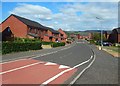
Taylor Street, Dalquhurn
The view is from near the southwestern end of the street. The houses shown here were built c.2011.
The picture was taken in connection with a Geograph article (linked from the first end-note) describing my research into the former location of the farm buildings of Pillanflatt. The farm seems to have been in existence in 1841, but its buildings had completely disappeared by the time the earliest OS map of the area was surveyed in 1860.
Pillanflatt's eastern building, which was probably the farmhouse, stood near the white van that is facing away from the viewer (the van's fortuitous position happens to make it a good reference point).
The two western buildings stood at about the spot from which the picture was taken (shown in Image).
The eastern building and two western buildings being referred to here are the ones shown on an 1841 plan: to view the relevant part of that plan, see https://www.geograph.org.uk/article/The-location-of-Pillanflatt-Farm#comparisons in the article already mentioned.
The old line of a track called the Howgate, which appears originally to have provided access to Pillanflatt Farm, passed through the houses on the right (the southern side of the street). See also Image, a view in the opposite direction.
The old course of the Howgate, in relation to present-day features, is best seen in the annotated satellite view that is linked from the first end-note. In that view, the old course of the track is marked as a yellow line. The Howgate now follows a slightly different route, a little further to the south, which marked as a green line on the annotated satellite view.
Image: © Lairich Rig
Taken: 27 Jun 2018
0.06 miles
5
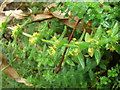
Crosswort (Laevigata cruciata)
These plants were probably shocked into flower because the surrounding woodland had been recently felled. April-June the usual flowering period.
http://www.wildflowersofstrathclydepark.org.uk/Crosswort.htm
Image: © Stan Campbell
Taken: 31 Oct 2007
0.06 miles
6
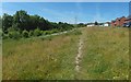
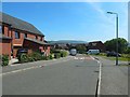
Path at the southern end of Dalquhurn
The path shown receding from view is a recent one, but it will be used below as a reference for describing the original course (no longer apparent on the ground) of a track called the Howgate.
The annotated satellite view linked from the first end-note shows the original line of the Howgate as a yellow line.
As that satellite view shows, the *original* line of the Howgate is almost the same as the path that leads directly ahead in the present picture.
For a view in the opposite direction, see Image; as noted there, the Howgate crossed what is now the site of the houses that are shown on the right in that image, on the southern side of the street.
The *current* line of the Howgate is, in contrast, a well-made track that is located beyond the trees on the left, and is on the other side of a wall. Its course is shown as a green line on the annotated satellite view.
Image: © Lairich Rig
Taken: 27 Jun 2018
0.08 miles
7
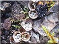
Birds Nest fungi (Crucibulum laeve)
Sometimes found on old bits of wood in industrial sites.
http://www.uksafari.com/birdsnestfungi.htm
Image: © Stan Campbell
Taken: 22 Oct 2006
0.08 miles
8

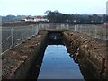
The lade at Dalquhurn
The water is flowing towards the point from which the picture was taken; the lade outflow (Image) is some way behind the photographer. The works for which the lade was constructed are long gone, but the lade itself has been preserved as a feature of the new housing estate.
(The picture was taken from Taylor Street. When this image was being submitted, not all scales of OS mapping showed the housing, which was new, and they showed nearby parts of the lade as still covered up; some parts of the lade were uncovered before construction of houses began, and it was decided that they should be left exposed to view.)
Image: © Lairich Rig
Taken: 6 Jul 2018
0.08 miles
9
The lade at Dalquhurn
By 2018, when this picture was submitted, a new housing development had been built alongside the lade, which was left open: Image Click on the end-note title for other views of the lade at different periods.
Image: © Lairich Rig
Taken: 22 Jan 2010
0.09 miles
10
Dalquharn Works Renton
Dalquharn Works Renton once a Cotton Mill and Print and Dye works
Image: © Eddie Mackinnon
Taken: 10 Apr 2006
0.09 miles