IMAGES TAKEN NEAR TO
Cardross Road, DUMBARTON, G82 4JH
Introduction
This page details the photographs taken nearby to Cardross Road, G82 4JH by members of the Geograph project.
The Geograph project started in 2005 with the aim of publishing, organising and preserving representative images for every square kilometre of Great Britain, Ireland and the Isle of Man.

There are currently over 7.5m images from over14,400 individuals and you can help contribute to the project by visiting https://www.geograph.org.uk
Image Map
Images are licensed for reuse under creativecommons.org/licenses/by-sa/2.0
Notes
- Clicking on the map will re-center to the selected point.
- The higher the marker number, the further away the image location is from the centre of the postcode.
Image Listing (69 Images Found)
Images are licensed for reuse under creativecommons.org/licenses/by-sa/2.0
Image
Details
Distance
1
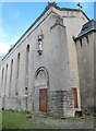
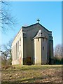
Chapel of the Sisters of Notre Dame
The South wall of the Chapel of Convent of the Sisters of Notre Dame at Cardross Road, Dumbarton i
Image: © Eddie Mackinnon
Taken: 13 May 2007
0.01 miles
2
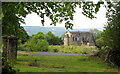
Chapel of Notre Dame Convent Dumbarton
The Chapel of the former Convent of the Sisters of Notre Dame at Cardross Road, Dumbarton is all that is left of the former Convent and Our Lady of Peace High School the chapel is hopefully to be Converted into six residential units. The community of the Sisters of Notre Dame have moved into nearby Craigend House
Image: © Eddie Mackinnon
Taken: 13 May 2007
0.01 miles
3
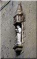
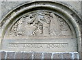
Statue on south wall of Chapel
A statue on the South wall of the former Chapel of Convent of the Sisters of Notre Dame at Cardross Road
Image: © Eddie Mackinnon
Taken: 13 May 2007
0.01 miles
4
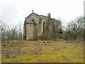
Ruined chapel in Dumbarton
Former nun convent between Brucehill and Westcliffe.
Image: © Stephen Sweeney
Taken: 23 Mar 2011
0.01 miles
5
Notre Dame Roman Catholic Chapel
This building was the Image; see that item, as well as Image, for further information, and for additional views.
The chapel stands at the top of a crag, above Image For further information on the chapel and the now-demolished convent (which was adjacent to the chapel, on the ENE side), see their listed building report: http://portal.historic-scotland.gov.uk/designation/LB24870 (at Historic Environment Scotland).
The southern side of the building is shown to better effect at the second of the links in the first paragraph. Above the bricked-up doorway on that side of the building is a sculpted tympanum with a Latin inscription: Image Above it is a statue: Image
For the northern side of the chapel, see Image For a view of the building as a whole from a different angle, see Image (my own picture was, by chance, taken on the following day).
At the time of the first-edition OS map (surveyed in 1860), Clarkhill House stood nearby, at Image (about 40m to the ENE of the spot where the chapel would later be built); it therefore stood at more or less the spot from which Image was taken. Its name corresponds to the "Clerkhil" of the Pont/Blaeu map, which was based on surveys in the 1580s-90s; for this and other old names in the area, see Image
In 1912, Notre Dame School appeared, immediately to the north and east of Clarkhill House (which was then still standing). By the 1920s, Clarkhill House was gone; the Notre Dame convent had, by then, been built on the same site. The chapel was a slightly later addition; it appeared in the mid-1930s.
Notre Dame School, which was immediately to the north of the convent, would expand considerably over the next few decades, being rebuilt in 1969; its buildings were demolished after that school merged with another in 1990: see Image
Image: © Lairich Rig
Taken: 24 Mar 2011
0.02 miles
6
Plaque on South wall of the Chapel
Plaque on the South wall of the disused Chapel of Convent of the Sisters of Notre Dame at Cardross Road
Image: © Eddie Mackinnon
Taken: 13 May 2007
0.02 miles
7
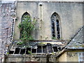
North facing windows of the Chapel
Windows which face north on the former Chapel of Convent of the Sisters of Notre Dame at Cardross Road, Dumbarton
Image: © Eddie Mackinnon
Taken: 13 May 2007
0.03 miles
8
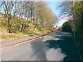
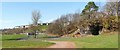
Havoc Road
This photograph was taken from a point close to the lamp post that is at the centre of the following photo: Image The present photograph shows the part of the road that is, in that other picture, hidden from sight by the crag (which is a raised beach). For the view from a point further along the road, see Image
The road and the area take the name Havoc from a farm that used to be located on the shore near here: Havock (the original spelling) was located at Image; that site is shown in Image and Image
The name is an old one; Blaeu's map of the Lennox, based on Timothy Pont's surveys in the 1580s-90s, shows it in the form "Heuack" (for this, and other old names nearby, see Image).
Image: © Lairich Rig
Taken: 24 Mar 2011
0.04 miles
9
Havoc Hole
This photograph shows a cave called Havoc Hole; it has other names (see the end-note). It appears as a dark area on the right, where it is set into a crag; the latter is, in origin, a raised beach. For more information about the cave, see Image
The houses in the background, on the left, are in Image The building visible below them, at the edge of the playing fields, is Havoc Sports Pavilion.
Image: © Lairich Rig
Taken: 24 Mar 2011
0.04 miles
10
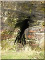
Havoc Hole
For a discussion of the cave's traditional associations with William Wallace, see the main article: Image
The cave opening here is a little over six feet high. The passage rapidly narrows, so that it is not possible to progress more than a few feet into the cave; it was perhaps deliberately blocked to prevent people from disappearing into it.
Image: © Lairich Rig
Taken: 21 Nov 2008
0.04 miles