Notre Dame Roman Catholic Chapel
Introduction
The photograph on this page of Notre Dame Roman Catholic Chapel by Lairich Rig as part of the Geograph project.
The Geograph project started in 2005 with the aim of publishing, organising and preserving representative images for every square kilometre of Great Britain, Ireland and the Isle of Man.

There are currently over 7.5m images from over 14,400 individuals and you can help contribute to the project by visiting https://www.geograph.org.uk
Notre Dame Roman Catholic Chapel
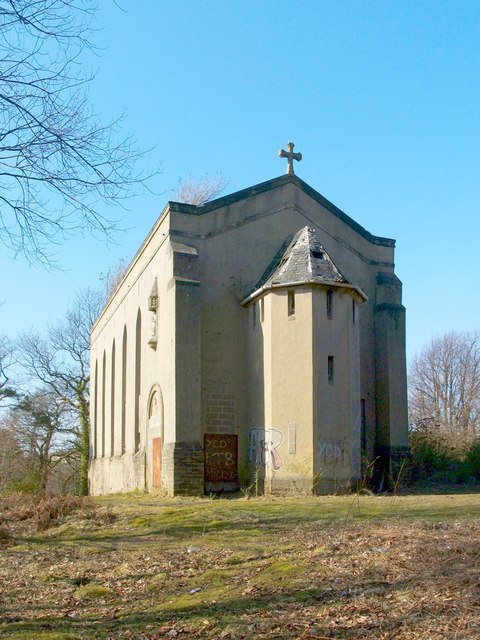
Image: © Lairich Rig Taken: 24 Mar 2011
This building was the Image; see that item, as well as Image, for further information, and for additional views. The chapel stands at the top of a crag, above Image For further information on the chapel and the now-demolished convent (which was adjacent to the chapel, on the ENE side), see their listed building report: http://portal.historic-scotland.gov.uk/designation/LB24870 (at Historic Environment Scotland). The southern side of the building is shown to better effect at the second of the links in the first paragraph. Above the bricked-up doorway on that side of the building is a sculpted tympanum with a Latin inscription: Image Above it is a statue: Image For the northern side of the chapel, see Image For a view of the building as a whole from a different angle, see Image (my own picture was, by chance, taken on the following day). At the time of the first-edition OS map (surveyed in 1860), Clarkhill House stood nearby, at Image (about 40m to the ENE of the spot where the chapel would later be built); it therefore stood at more or less the spot from which Image was taken. Its name corresponds to the "Clerkhil" of the Pont/Blaeu map, which was based on surveys in the 1580s-90s; for this and other old names in the area, see Image In 1912, Notre Dame School appeared, immediately to the north and east of Clarkhill House (which was then still standing). By the 1920s, Clarkhill House was gone; the Notre Dame convent had, by then, been built on the same site. The chapel was a slightly later addition; it appeared in the mid-1930s. Notre Dame School, which was immediately to the north of the convent, would expand considerably over the next few decades, being rebuilt in 1969; its buildings were demolished after that school merged with another in 1990: see Image
Images are licensed for reuse under creativecommons.org/licenses/by-sa/2.0
Image Location
Latitude
55.945728
Longitude
-4.593928