IMAGES TAKEN NEAR TO
DUMBARTON, G82 4HH
Introduction
This page details the photographs taken nearby to G82 4HH by members of the Geograph project.
The Geograph project started in 2005 with the aim of publishing, organising and preserving representative images for every square kilometre of Great Britain, Ireland and the Isle of Man.

There are currently over 7.5m images from over14,400 individuals and you can help contribute to the project by visiting https://www.geograph.org.uk
Image Map
Images are licensed for reuse under creativecommons.org/licenses/by-sa/2.0
Notes
- Clicking on the map will re-center to the selected point.
- The higher the marker number, the further away the image location is from the centre of the postcode.
Image Listing (18 Images Found)
Images are licensed for reuse under creativecommons.org/licenses/by-sa/2.0
Image
Details
Distance
1
Cardross: Dalreoch, Succoth Lodge
on the Kipperoch Road
Image: © william craig
Taken: 17 Aug 2006
0.00 miles
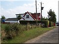
2
The Kipperoch Road at Succoth
Beside the road is a short row of houses. The nearest is called Succoth Lodge; for a closer view, see Image In about 2010, not long after the present picture was taken, another house was built on the near side of it, as shown in Image (taken in 2018).
(The tower that used to stand near here is discussed below.)
The names of most of these houses are, like the houses themselves, quite modern, but the name "Succoth" has been associated with this area for a very long time. A map of the region ("Levinia"), as surveyed by Timothy Pont in the 1580s and 1590s, but published by Joan Blaeu in 1654, shows it as "Sococh"; this is much closer to the original form of the name, which is evidently the Gaelic "Socach".
Likewise, Dumbarton's Burgh Records, in their entry for August 14th 1627, mention "R[ober]t Campbell of Sokkoch", probably referring to this location.
The word "socach" is defined by Dwelly's "Illustrated Gaelic English Dictionary" as a "certain extent of arable land" (evidently the most common meaning), and as "soccage, tenure of lands by service fixed and determined in quality". The definition ends with the comment "as a place-name Succoth in English". (For a similar example, see Image, where the corresponding Gaelic name Socach is shown on the OS map.)
[There are several examples of the place-name "Succoth" in Scotland; some of these I have seen explained as meaning, literally, "beak" or "snout" (from the Gaelic "soc"), and so, by extension, the pointed area of land enclosed by two streams above their point of confluence. Whether that proposed explanation is correct, and whether it applies in the present case, I cannot say.]
Why does "Socach" regularly become "Succoth" in English? I'm speculating that this is from the influence of the Biblical place-name Succoth (Hebrew סֻכּוֹת = "booths", "temporary dwellings"); this name occurs about 20 times in the Bible, and would therefore, in centuries past, have been quite familiar.
- - • - -
The old farm-house of Succoth stood at about Image; it is marked on the first-edition OS map (based on surveys made in 1860) and on the second-edition map (based on revisions made in 1896).
By the time of the next revision of the map (1914), that building had gone. Its stones, though, were not wasted, but were used to build a tower that stood alone in the field, near the former site of the farm-house, for several decades; see Image for that general area.
That tower, which was therefore of no antiquity, is probably to be identified with a small square structure that is marked at about Image on the 1914 and 1937 revisions of the map. Visitors could, after seeking the farmer's permission, enjoy a very fine view from the top.
Image: © Lairich Rig
Taken: 16 Oct 2009
0.01 miles
3
The Kipperoch Road at Succoth
The nearest house, Oakwood, is recent (built c.2010), and is not shown in the equivalent view from 2009: Image Succoth Lodge, at that time the nearest house, is now the second-nearest; part of it is visible in the present picture.
Image: © Lairich Rig
Taken: 22 Jun 2018
0.05 miles
4
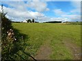
Field at Succoth
The view is from a field gate. Almost straight head, and only a little nearer than the house on the left, was, at one time, the site of Succoth Tower; now long gone, it was of no great antiquity: it had been built from the rubble of Succoth Farmhouse. See Image for further details.
Image: © Lairich Rig
Taken: 29 Aug 2016
0.06 miles
5
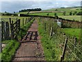
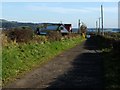
Knowetop Community Farm
This is a view away from the main farm buildings; the hedge visible at the far end of the footpath marks the boundary between Knowetop and adjacent farmland.
See also Image, Image, Image, and Image
Image: © Lairich Rig
Taken: 9 Sep 2009
0.21 miles
6
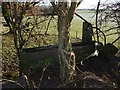
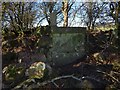
Ardochbeg: ruins of an ancillary building
The ruined house at Ardochbeg is shown in Image and Image (click on the end-note title for related pictures).
However, there was a longer, narrow building a short distance to the east of the house. The present photograph shows the remains of that building, whose long axis was, as the disposition of the rubble suggests, oriented along the line of sight; it was also internally divided.
This long building had already been demolished by the start of the First World War, while the house itself, just to the west, remained standing and was occupied up until the Second World War.
Image: © Lairich Rig
Taken: 8 Jan 2018
0.22 miles
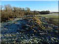
7
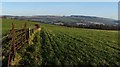
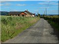
Fields near Dalmoak
The escarpment of the Kilpatrick Hills (Image) is on the right, with the housing estate of Bellsmyre spread out before it.
Image: © Lairich Rig
Taken: 12 Jan 2012
0.23 miles
8
Ruins of Ardochbeg: remains of a window
This is a view from inside the ruin. There was a small room at the end, with this window. For views of it from the outside see Image (from nearby) and Image (a more distant context view).
Image: © Lairich Rig
Taken: 8 Jan 2018
0.24 miles
9
Ruins of Ardochbeg: remains of a window
This is a view from outside the ruin; For context, see Image
My examination of the interior of the ruin showed that there was a small room at this end; this is the remains of its window-frame and of the wall supporting it. For a view of it from within the ruin, see Image
Image: © Lairich Rig
Taken: 8 Jan 2018
0.24 miles
10
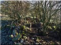
Ardochbeg: inside the ruin
Members of my own family once lived here. The two upright rectangular stones visible ahead divide the larger room from which the picture was taken from a smaller room behind. See Image, taken within that end of the ruin.
As for the two upright stones, the one on the left has, on the side facing the other, a circular hole to accommodate a bar or bolt. For closer views, see Image and Image, the second of which shows the hole.
Image: © Lairich Rig
Taken: 8 Jan 2018
0.24 miles