IMAGES TAKEN NEAR TO
Glencairn Road, DUMBARTON, G82 4DP
Introduction
This page details the photographs taken nearby to Glencairn Road, G82 4DP by members of the Geograph project.
The Geograph project started in 2005 with the aim of publishing, organising and preserving representative images for every square kilometre of Great Britain, Ireland and the Isle of Man.

There are currently over 7.5m images from over14,400 individuals and you can help contribute to the project by visiting https://www.geograph.org.uk
Image Map
Images are licensed for reuse under creativecommons.org/licenses/by-sa/2.0
Notes
- Clicking on the map will re-center to the selected point.
- The higher the marker number, the further away the image location is from the centre of the postcode.
Image Listing (48 Images Found)
Images are licensed for reuse under creativecommons.org/licenses/by-sa/2.0
Image
Details
Distance
1
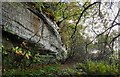
Cliffs at Brucehill
The map shows a bunching a contour lines here (the cliffs), and a flat area in front. The flat area is a raised beach, and these cliffs were once sea-cliffs (Image / Image).
From a distance, the rock face shown here is screened by trees (compare Image). Dripping water keeps the surface damp, creating a home for liverworts and ferns such as Royal Fern (see Image).
See Image for a view in the opposite direction.
Image: © Lairich Rig
Taken: 27 Oct 2017
0.09 miles
2
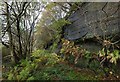
Cliffs at Brucehill
The contour lines on the map reveal the presence of cliffs here (they are former sea-cliffs) and a flat area in front (which is a raised beach).
For further comments, see Image, a view in the opposite direction.
Image: © Lairich Rig
Taken: 27 Oct 2017
0.09 miles
3
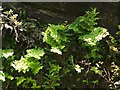
Royal Fern colony
The ferns are growing high up on Brucehill Cliffs, which are part of a Local Nature Conservation Site; see Image for details (and for the context).
The work that is cited there notes that the cliffs, which are of red sandstone, "are almost constantly wet, and the dripping water sustains an interesting floral community, most notably the locally rare royal fern – the largest colony in West Dunbartonshire. The ferns are rooted directly into the cliff faces."
In "A Natural History of Britain's Ferns" (1988), Christopher N. Page devotes a section to "Cliff-face Royal Fern Communities"; he notes there that where the Royal Fern (Osmunda regalis) "is present in cliffside habitats it usually occurs mainly as very numerous but mostly juvenile plants ... Only occasional plants have fertile fronds ...", and he mentions that, although sometimes the ferns occur singly at such sites, "where the spread of run-off water creates fairly large areas of permanently damp rock, quite dense colonies with numerous plants may occur".
That description fits this environment very well; no fertile fronds were apparent when I took this photograph (contrast Image and Image, where some typically narrow, upright, brownish fertile fronds can be seen in the centre of the clumps).
Page also notes that acidic, peaty run-off water can provide a suitable cliffside habitat for Osmunda regalis (Royal Fern), while lime-rich run-off is suitable for Adiantum capillus-veneris (Maidenhair Fern).
Image: © Lairich Rig
Taken: 1 Jul 2011
0.09 miles
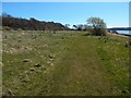
4
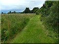
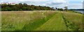
Path in Havoc Grassland
The trees on the right hide a line of cliffs, and wild flowers cover the raised beach to the left. See Image for a view in the opposite direction from the same place.
Image: © Lairich Rig
Taken: 21 Jul 2017
0.11 miles
5
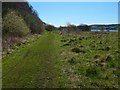
Brucehill Cliffs and Havoc Grassland
Section 17 of the book "Wildlife Around Glasgow" (2010, Richard Sutcliffe) is devoted to Brucehill Cliffs and Havoc Grassland. The book notes that the site is designated a Local Nature Conservation Site and proposed as a Local Nature Reserve.
The area is a raised beach, with former sea-cliffs of red sandstone (visible to the left, among the trees). The Image can be seen at the north-western end of the line of cliffs, beside Image The grassland, which is of recent origin, is rich in orchids and other flowers. The cliffs support their own distinctive species; see, for example, Image
At the extreme right is the River Clyde; Image follows the head of the beach.
See Image for a view of the same area from higher up.
Image: © Lairich Rig
Taken: 1 Jul 2011
0.12 miles
6
Brucehill Cliffs and Havoc Grassland
The cliffs, on the left, are hidden for much of their length by trees. A house visible ahead is part of the Keil Mansions development (see Image).
Image: © Lairich Rig
Taken: 20 Apr 2016
0.13 miles
7
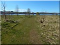
Havoc Grassland
For details on the far shore of the Clyde, at the left, see Image Port Glasgow is at the far right.
Image: © Lairich Rig
Taken: 20 Apr 2016
0.14 miles
8
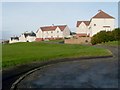
Firthview Terrace, Brucehill
The viewpoint is a few metres from the top of the steps shown here: Image For the grassy area to the left of the houses, see Image
Image: © Lairich Rig
Taken: 21 Nov 2008
0.15 miles
9
Havoc Grassland
There has been some planting of native trees here, near the shore.
Image: © Lairich Rig
Taken: 20 Apr 2016
0.15 miles
10

Path in Havoc Grassland
The trees to the left hide a line of cliffs, and wild flowers cover the raised beach on the right. See Image for a view in the opposite direction from the same place.
Image: © Lairich Rig
Taken: 21 Jul 2017
0.15 miles