IMAGES TAKEN NEAR TO
Clyde Court, West Bridgend, DUMBARTON, G82 4BT
Introduction
This page details the photographs taken nearby to Clyde Court, West Bridgend, G82 4BT by members of the Geograph project.
The Geograph project started in 2005 with the aim of publishing, organising and preserving representative images for every square kilometre of Great Britain, Ireland and the Isle of Man.

There are currently over 7.5m images from over14,400 individuals and you can help contribute to the project by visiting https://www.geograph.org.uk
Image Map
Images are licensed for reuse under creativecommons.org/licenses/by-sa/2.0
Notes
- Clicking on the map will re-center to the selected point.
- The higher the marker number, the further away the image location is from the centre of the postcode.
Image Listing (245 Images Found)
Images are licensed for reuse under creativecommons.org/licenses/by-sa/2.0
Image
Details
Distance
1
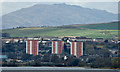
Dumbarton towerblocks
Viewed across the River Clyde from Golf Road, Bishopton.
See them from a different angle Image
Image: © Thomas Nugent
Taken: 16 Apr 2018
0.02 miles
2
West Bridgend And The River Leven
The three multi-storey blocks of flats at West Bridgend are prominent in this shot taken from White Tower Craig, Dumbarton Rock.
Image: © James T M Towill
Taken: 4 Sep 2011
0.03 miles
3
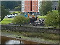
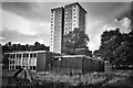
Demolition of West Bridgend Community Centre
The view is from Image For more context, see Image
In the present view, the rubble from the community centre is directly in front of Clyde Court, one of Image
For a view of the demolition site from another angle, and for further information, see Image
Image: © Lairich Rig
Taken: 26 Sep 2017
0.03 miles
4
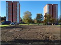
The cleared site of West Bridgend Community Centre
The Community Centre is shown intact in an earlier picture (Image), and being cleared away in Image and Image, leaving the site as shown here. It was originally intended that a new community centre be built in the same place, but by early 2019 the site was grassed over.
There are three high flats at West Bridgend: Image The ones in the present picture are Clyde Court (left) and Lomond Court. Leven Court is out of shot to the right.
Image: © Lairich Rig
Taken: 2 Nov 2017
0.03 miles
5
Unrecorded bench mark
Well, possibly. Placed almost centrally in the upper half of the picture is an inscribed arrow (more easily felt than seen). Though it is not apparent in the image, touch also reveals a deeper indentation at the apex, which probably held a metal bolt or stud.
No bench mark is recorded here by the OS, and the marking is (at least, in this lighting) scarcely noticeable. I just happened to think about bench marks as I passed this spot, and looked for (and found) this one. It is low down on the stonework just to the right of the gate that is shown in Image and in the earlier Image
I cannot be certain that this one genuinely is an OS bench mark, but it seemed worth recording for future reference.
Image: © Lairich Rig
Taken: 13 Oct 2017
0.03 miles
6
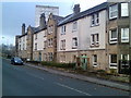
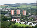
Tenements in Dumbarton
On West Bridgend.
Image: © Stephen Sweeney
Taken: 25 Nov 2007
0.03 miles
7
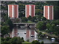
View from Dumbarton Rock towards Dumbarton Bridge & Clyde & Lomond Courts
Image: © Colin Park
Taken: 6 Jun 2012
0.04 miles
9

Gate at West Bridgend
The gate (shown in an earlier picture, Image) has long been closed, but the track behind it used to be a convenient shortcut to the parts of Helenslee Road above the Image Image is in the background.
Image: © Lairich Rig
Taken: 21 Feb 2013
0.04 miles
10

Demolition of West Bridgend Community Centre
The view is from Image For more context, see Image, taken a day earlier.
The community centre had been deemed unsafe, and was being demolished.
The picture was taken on a Tuesday; for a view from a different angle on the same day, see Image By the weekend, everything above ground level had been cleared away: Image
For pictures showing or including the community centre before it was demolished, see Image / Image / Image / Image
It was originally intended that a new community centre be built in the same place, but by early 2019 the site was grassed over.
Image: © Lairich Rig
Taken: 26 Sep 2017
0.04 miles