IMAGES TAKEN NEAR TO
West Bridgend, DUMBARTON, G82 4AD
Introduction
This page details the photographs taken nearby to West Bridgend, G82 4AD by members of the Geograph project.
The Geograph project started in 2005 with the aim of publishing, organising and preserving representative images for every square kilometre of Great Britain, Ireland and the Isle of Man.

There are currently over 7.5m images from over14,400 individuals and you can help contribute to the project by visiting https://www.geograph.org.uk
Image Map
Images are licensed for reuse under creativecommons.org/licenses/by-sa/2.0
Notes
- Clicking on the map will re-center to the selected point.
- The higher the marker number, the further away the image location is from the centre of the postcode.
Image Listing (184 Images Found)
Images are licensed for reuse under creativecommons.org/licenses/by-sa/2.0
Image
Details
Distance
1
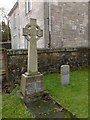
War Memorial from Dalreoch Church
For context, see Image; the building behind the memorial is the one that appears at the far left in that picture, and the direction of view is more or less the same.
The memorial is now located just to the south of the church halls of the West Kirk, but it originally stood beside Dalreoch Church. Dalreoch Church, now demolished, was located not far from here, at about Image; it was built in 1873, and it was designed by Dumbarton's town architect John McLeod (Image). The same architect was responsible for the West Kirk itself: see Image
The Dalreoch and West Bridgend congregations eventually merged, and they would meet at the West Bridgend church building, which became known as the West Kirk. The Dalreoch Church building was later demolished (in 1984), so the war memorial associated with that congregation was brought here.
This is a memorial for those who died in the First World War. Another First World War memorial, made of bronze, is located within the West Kirk itself; that bronze memorial is the one associated with the (pre-merger) West Bridgend congregation. The unveiling of the two war memorials is reported in the 15th October 1921 edition of the "Lennox Herald" newspaper. Neither of the two bears any text identifying which congregation it is associated with, but there was no need to do so before the congregations merged, since the two memorials were, until then, located beside different church buildings.
The Dalreoch memorial, shown in the present photograph, is described in the newspaper article as being in the form of an Ionic cross (i.e., a Celtic cross), and the official presentation was presided over by the minister R.A.Orr. "The stone was supplied by Bailie Gilfillan, sculptor, Dumbarton"; this is a reference to John Gilfillan, on whom see Image (a bailie is a municipal magistrate; see the inscription at the link just given). The newspaper article also notes that Dalreoch was the first of the local churches to have its war memorial placed outside the church.
The smaller memorial on the right is for Private William C. Douglas, Royal Army Medical Corps, who died on the 7th December 1916, aged 19.
A burial ground was formerly associated with the original church here at West Bridgend. It has largely been cleared away (Image), and the very few remaining stones are located near this spot: Image / Image
Image: © Lairich Rig
Taken: 14 Jan 2013
0.01 miles
2
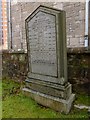
Dumbarton West Kirk: the MacAuslan Memorial
"Erected to the memory of John MacAuslan, timber merchant, Dumbarton, born 4th April 1804, died 17th February 1875, etc. .... Mark the perfect man and behold the upright, for the end of that man is peace – Psalm XXXVII 37".
Also named are Janet Leitch (his mother), several children, Margaret Ure (his wife), and a later descendant.
The memorial is one of the very few that remain of those originally associated with Image For context, see Image; this memorial stands beside the building that is at the far left in that picture. It is only a few feet from Image (as a comparison of the background of that and the present picture makes clear).
The MacAuslan Memorial was sculpted by Mr Young (Image). John MacAuslan, first-named in the inscription, was the son of James MacAuslan, farmer at Hawthornhill (that farm is long gone, but it was located in the area shown in Image, to the right of the far end of the hedge-lined path).
John was apprenticed to Daniel Taylor in 1821. In 1834, he began business as a joiner and timber merchant. For a short time, he was also a shipbuilder; his premises were near here (this area is called West Bridgend). After Dumbarton's Glass Works had closed (see Image), he bought that site, and went on to build Woodside Crescent and Woodside Saw Mills there. He married Margaret, daughter of the ironfounder John Ure, in 1843. They had fourteen of a family. John MacAuslan was a councillor for many years, and he also served as Dean of Guild.
[Biographical details summarised from Donald MacLeod's "The God's Acres of Dumbarton" (1888).]
Image: © Lairich Rig
Taken: 14 Jan 2013
0.01 miles
3
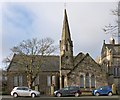
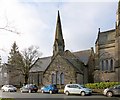
Dumbarton West Kirk: church halls
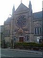
See Image for another view. This 1860 building by William Spence was the immediate predecessor of the present-day Image (the building on the right), and it now serves as church halls for the West Kirk.
For the detail in the right background, see Image
Image: © Lairich Rig
Taken: 14 Jan 2013
0.01 miles
4
Dumbarton West Kirk: the Buchanan Memorial
The picture was taken from the vicinity of the MacAuslan Memorial (Image). The area shown here is behind the church halls (Image). For what is just out of shot to the right, see Image
The memorial at the centre of the picture has the name "Buchanan" carved in relief on its base. On its near side, it commemorates a Captain William Buchanan who died at Kinneil, Lamlash, on 25 October 1890, aged 67; his wife Ann Walker who died in the same place on 12 April 1901, aged 79; and their children.
An inscription on the right-hand side commemorates a different Captain William Buchanan, a Glasgow steamboat owner, who died at Kinneil on the 1st of June 1911, aged 62; and his son, who was killed in the First World War.
Image: © Lairich Rig
Taken: 14 Jan 2013
0.02 miles
5
Dumbarton West Kirk: church halls
This building dates from 1860; the architect was William Spence. As a church, it was superseded by the present-day Image, the building on the right (see that link for much more information). However, the 1860 building is still in use, serving as church halls for the West Kirk. See Image for another view.
Both buildings were successors to the original West Bridgend church, which was built in the 1790s.
Image: © Lairich Rig
Taken: 14 Jan 2013
0.02 miles
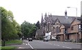
6
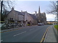
Old house and church in Dumbarton
On West Bridgend.
Image: © Stephen Sweeney
Taken: 25 Nov 2007
0.02 miles
7
Dumbarton West Kirk
Church on West Bridgend.
Image: © Stephen Sweeney
Taken: 25 Nov 2007
0.02 miles
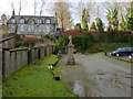
8
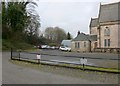
Dumbarton West Kirk: former burial ground
This area behind the church halls of the West Kirk (Image) was, until recent times, a burial ground. In the 1790s, land was feued here for the building of a church (that building is no longer present, but has been replaced twice since then), and for a burial ground.
The building that now serves as church halls (see the link just given) dates from 1860, and was the first of the replacements for the original church. It, in turn, was replaced by the present-day West Kirk, whose rear is visible in the right background of the present photograph. See Image for a view of that building, and for much more information.
When the burial ground was surveyed in 1969, there were still numerous memorials here, but it is obvious from this picture that they have been cleared away since then. Only the MacAuslan Memorial and the Buchanan Memorial remain: Image / Image There is also a War Memorial nearby: Image
Image: © Lairich Rig
Taken: 11 Jan 2013
0.03 miles
10
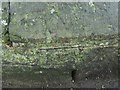
Unrecorded bench mark
Well, possibly. Placed almost centrally in the upper half of the picture is an inscribed arrow (more easily felt than seen). Though it is not apparent in the image, touch also reveals a deeper indentation at the apex, which probably held a metal bolt or stud.
No bench mark is recorded here by the OS, and the marking is (at least, in this lighting) scarcely noticeable. I just happened to think about bench marks as I passed this spot, and looked for (and found) this one. It is low down on the stonework just to the right of the gate that is shown in Image and in the earlier Image
I cannot be certain that this one genuinely is an OS bench mark, but it seemed worth recording for future reference.
Image: © Lairich Rig
Taken: 13 Oct 2017
0.03 miles