IMAGES TAKEN NEAR TO
DUMBARTON, G82 3PH
Introduction
This page details the photographs taken nearby to G82 3PH by members of the Geograph project.
The Geograph project started in 2005 with the aim of publishing, organising and preserving representative images for every square kilometre of Great Britain, Ireland and the Isle of Man.

There are currently over 7.5m images from over14,400 individuals and you can help contribute to the project by visiting https://www.geograph.org.uk
Image Map
Images are licensed for reuse under creativecommons.org/licenses/by-sa/2.0
Notes
- Clicking on the map will re-center to the selected point.
- The higher the marker number, the further away the image location is from the centre of the postcode.
Image Listing (47 Images Found)
Images are licensed for reuse under creativecommons.org/licenses/by-sa/2.0
Image
Details
Distance
1
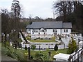
Glen Cottage
A very elegant cottage making good use of the Murroch Burn.
Image: © william craig
Taken: 23 Mar 2006
0.01 miles
2
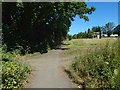
The start of a path
The path described in the end-note begins here, leading off to the left; this is the northern (or Lion's Gate) end of the path. Image itself can be seen in the right background. The path receding from view is the pavement near the main road (Stirling Road).
Image: © Lairich Rig
Taken: 4 Jul 2018
0.06 miles
3
The end of a path
The top of a house can be seen ahead; it is Image
For a view in the opposite direction along this part of the path, see Image Not far ahead, it meets the pavement near Stirling Road, as shown in Image
Image: © Lairich Rig
Taken: 4 Jul 2018
0.06 miles
4
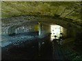
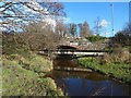
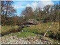
The Murroch Burn flowing under a bridge
The bridge is the one shown in Image, and the view direction is the same, looking upstream. As noted at the other link, the bridge takes Stirling Road over the Murroch Burn.
Image: © Lairich Rig
Taken: 4 Jul 2018
0.06 miles
5
The Lion's Gate
This structure stands alone, and bears the inscription "Vale of Leven Industrial Estate"; it stands beside one of the roads leading into that estate (also known as Strathleven Industrial Estate).
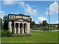
The gate used to be flanked by two stone lions, but these were taken away in the 1960s. The much more recent Lionsgate Roundabout can also be seen in the photo, and its name refers to the stone lions. Before the Vale of Leven Industrial Estate was created, and when the area that it now occupies was simply the estate of Image, a lodge associated with that house stood here, close to the Lion's Gate.
King Robert the Bruce was said to have kept a pet lion somewhere in the vicinity of modern-day Strathleven (which is very close to this spot). The lion was taken to Scone for Robert's coronation; it is mentioned in the exchequer rolls (financial records) for that occasion.
Image: © Lairich Rig
Taken: 4 Aug 2008
0.07 miles
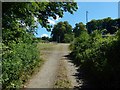
6
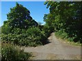
The start of a path
This is the "Lion's Gate" end of the path described in the end-note. The path starts here beside Stirling Road, and leads straight ahead. For a view from another angle, see Image For a view back along this part of the path, see Image
(The present picture is intended to supersede or at least supplement an earlier poor photo: Image)
Image: © Lairich Rig
Taken: 4 Jul 2018
0.07 miles
7
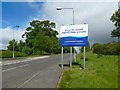
Welcome to Vale of Leven Industrial Estate
The sign is new.
Image: © Lairich Rig
Taken: 29 May 2015
0.07 miles
8
The Murroch Burn at Kilmalid
The subject is as in Image, but the view is from the area that is, in that picture, at the far left. The bridge that takes Stirling Road over the burn is visible in both pictures.
For the reverse view, looking back to this spot from the bridge, see Image For a view under the bridge, from this side, see Image
Image: © Lairich Rig
Taken: 5 Mar 2017
0.08 miles
9
The Murroch Burn at Kilmalid
The bridge visible ahead carries Stirling Road over the burn. For a view from the area that is at the far left, see Image
Image: © Lairich Rig
Taken: 5 Mar 2017
0.08 miles
10

Aggreko, Dumbarton
New premises in the Vale of Leven Industrial Estate.
Image: © Stephen Sweeney
Taken: 4 Sep 2012
0.08 miles