IMAGES TAKEN NEAR TO
Stuart Road, DUMBARTON, G82 3NQ
Introduction
This page details the photographs taken nearby to Stuart Road, G82 3NQ by members of the Geograph project.
The Geograph project started in 2005 with the aim of publishing, organising and preserving representative images for every square kilometre of Great Britain, Ireland and the Isle of Man.

There are currently over 7.5m images from over14,400 individuals and you can help contribute to the project by visiting https://www.geograph.org.uk
Image Map
Images are licensed for reuse under creativecommons.org/licenses/by-sa/2.0
Notes
- Clicking on the map will re-center to the selected point.
- The higher the marker number, the further away the image location is from the centre of the postcode.
Image Listing (75 Images Found)
Images are licensed for reuse under creativecommons.org/licenses/by-sa/2.0
Image
Details
Distance
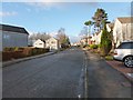
1
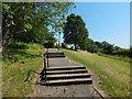
Path to Stuart Avenue
The path branches off from a Image (itself part of an old avenue leading to Image). It branches off at a point lower than the one from which that picture was taken.
The path shown here in fact leads to Stuart Road, Fraser Avenue, Campbell Terrace, and other streets joined to the southern half of Campbell Avenue; the title merely refers to the nearest of them.
Image: © Lairich Rig
Taken: 29 Jun 2018
0.04 miles
2
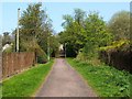
Path to Overtoun Estate
This path is a remnant of an Image that was built in the nineteenth century.
The path leads from Image to one of the entrances of the present-day Overtoun Estate (Image), and forms part of two circular walks, namely, The Crags Circular Path and Overtoun House Circular Path.
For a view from further along the path, see Image
Image: © Lairich Rig
Taken: 19 Apr 2011
0.09 miles
3
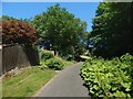
Path to Overtoun Estate
The view is similar to Image, taken earlier in the year (though a different year); note the large Butterbur leaves to the right of the path.
Image: © Lairich Rig
Taken: 29 Jun 2018
0.09 miles
4
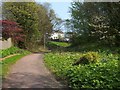
Path to Overtoun Estate
This photograph was taken just a little further along the path that is shown in Image; see that item for further information.
Visible not far ahead, in the present photograph, are the backs of some of the houses on Image There is an extensive patch of Butterbur on the right; the leaves are much larger when fully grown.
This path is a remnant of an Image that was built in the nineteenth century.
Image: © Lairich Rig
Taken: 19 Apr 2011
0.10 miles
5
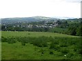
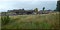
View across Crosslet, Dumbarton
From the path to Barnhill Road.
Image: © Stephen Sweeney
Taken: 31 May 2008
0.14 miles
6
Campbell Avenue, High Overtoun
See Image for further details. The present view is in the opposite direction; the picture was taken from near an entrance to the Overtoun Estate (Image).
Image: © Lairich Rig
Taken: 7 Dec 2012
0.15 miles
7
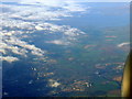
Dumbarton from the air
The River Leven is to the bottom left, whilst Ardmore Peninsula and the Firth of Clyde can be seen at the top. Taken from a flight which has just left Glasgow for Bristol.
Image: © Thomas Nugent
Taken: 11 Oct 2010
0.15 miles
8
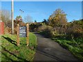
Avenue to Overtoun House
The view is from just beyond the gates shown in an earlier picture (Image), but the sign in the present picture is new, and does not appear in that earlier view. The avenue leads to Image
Image: © Lairich Rig
Taken: 30 Oct 2015
0.16 miles
9
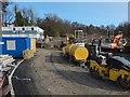
Construction at former site of Crosslet House
A new care home is being built here on the former location of Image The picture was taken from outside the construction site, and shows the northern end of the development.
Image: © Lairich Rig
Taken: 28 Feb 2016
0.16 miles
10
Demolition of the County Buildings
Comparison with an earlier picture, Image, shows that the platform just left of centre supported, until recently, the "single-storey county hall" mentioned in the end-note. The present picture is intended to represent the final stages of demolition; almost all of the buildings had, by this time, been reduced to rubble.
Image: © Lairich Rig
Taken: 16 Aug 2019
0.17 miles