IMAGES TAKEN NEAR TO
Garshake Road, DUMBARTON, G82 3LQ
Introduction
This page details the photographs taken nearby to Garshake Road, G82 3LQ by members of the Geograph project.
The Geograph project started in 2005 with the aim of publishing, organising and preserving representative images for every square kilometre of Great Britain, Ireland and the Isle of Man.

There are currently over 7.5m images from over14,400 individuals and you can help contribute to the project by visiting https://www.geograph.org.uk
Image Map
Images are licensed for reuse under creativecommons.org/licenses/by-sa/2.0
Notes
- Clicking on the map will re-center to the selected point.
- The higher the marker number, the further away the image location is from the centre of the postcode.
Image Listing (168 Images Found)
Images are licensed for reuse under creativecommons.org/licenses/by-sa/2.0
Image
Details
Distance

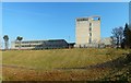
2
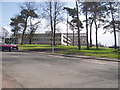
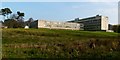
West Dunbartonshire Council Offices
Taken from Garshake Road
Image: © G McK
Taken: 6 Apr 2006
0.06 miles
3
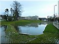
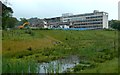
Flood storage pond at Garshake
See Image for the same area at an earlier stage in the construction process, and Image for a later view. In both pictures, Image can be seen in the background.
Image: © Lairich Rig
Taken: 12 Dec 2014
0.07 miles
4
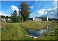
Flood storage pond at Garshake
Image are in the background.
The pond is shown under construction in Image, and with more water in Image
Image: © Lairich Rig
Taken: 4 Sep 2016
0.07 miles
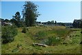
5
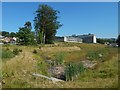
Flood storage pond at Garshake
The pond is empty after some prolonged dry weather; compare Image See Image for a view from another angle.
When the present picture was taken, the former Image behind the pond had been superseded by the Image
Image: © Lairich Rig
Taken: 29 Jun 2018
0.07 miles
6
Demolition of the County Buildings
The water in the foreground is a Image
Image: © Lairich Rig
Taken: 31 May 2019
0.07 miles
7
Demolition of the County Buildings
As Image, but taken about a month later.
Image: © Lairich Rig
Taken: 2 Jul 2019
0.07 miles
8
Flood storage pond at Garshake
The County Buildings, shown in the background of an equivalent earlier view, Image, have been reduced to rubble.
Image: © Lairich Rig
Taken: 25 Aug 2019
0.07 miles
9
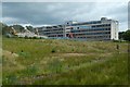
The County Buildings, Dumbarton
See the end-note for a more detailed description, and click on the end-note title for related pictures.
Until 2011, there were trees in the area shown in the foreground of the photograph. They were felled in advance of the creation of a flood storage pond in this area: Image / Image / Image
This will be part of a flood alleviation scheme; in the past, flooding has occurred when the waters of the Knowle Burn, which flows through this area, have been swollen by heavy rains; see Image on the burn.
Image: © Lairich Rig
Taken: 16 Nov 2011
0.07 miles
10
Former council offices
By the time the present picture was taken, these offices were no longer in use; they had been replaced by the building shown in Image
Image: © Lairich Rig
Taken: 15 Feb 2019
0.07 miles