
IMAGES TAKEN NEAR TO
Loaninghead Drive, DUMBARTON, G82 3ED
Introduction
This page details the photographs taken nearby to Loaninghead Drive, G82 3ED by members of the Geograph project.
The Geograph project started in 2005 with the aim of publishing, organising and preserving representative images for every square kilometre of Great Britain, Ireland and the Isle of Man.

There are currently over 7.5m images from over14,400 individuals and you can help contribute to the project by visiting https://www.geograph.org.uk
Image Map
Images are licensed for reuse under creativecommons.org/licenses/by-sa/2.0
Notes
- Clicking on the map will re-center to the selected point.
- The higher the marker number, the further away the image location is from the centre of the postcode.
Image Listing (40 Images Found)
Images are licensed for reuse under creativecommons.org/licenses/by-sa/2.0
Image
Details
Distance
1
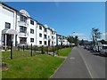
Merkins Avenue, Bellsmyre
The appearance of the buildings on this street has changed greatly in recent years. They looked very different about 30 years ago, when I passed through here more often.
Image: © Lairich Rig
Taken: 17 Jul 2017
0.04 miles
2
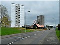
Bellsmyre High Flats: demolition in progress
For a corresponding picture taken almost a year earlier, when the buildings were all intact, see Image In both views, the nearest building is Kinglass House.
In the present photograph, Endrick House is being dismantled, and Fruin House is already gone (compare the earlier view). The low building by the roadside is the recently-built Cutty Sark Community Centre, which occupies the same site as its predecessor, Howatshaws Hall.
Image: © Lairich Rig
Taken: 31 Oct 2014
0.14 miles
3
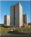
Bellsmyre High Flats
The site is being prepared for demolition. See Image for a view from a different angle.
Click on the end-note title for other pictures of the buildings, including some that were taken before the area was fenced off.
Image: © Lairich Rig
Taken: 23 Nov 2013
0.15 miles
4
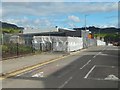
Construction on the Bellsmyre Campus
The site is adjacent to that of the new OLSP: Image
In the present picture, the finishing touches are being put on the Bellsmyre Campus; see also Image, taken on the same day.
Another contributor's pictures show it at the time of opening (two days later): Image (for more information) and Image (signage).
Image: © Lairich Rig
Taken: 21 Aug 2016
0.15 miles
5
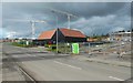
Construction on new OLSP site
This was formerly the location of the Bellsmyre High Flats: Image The new OLSP (Our Lady and St Patrick's High School) is being built here; see also Image
The building already standing is the Cutty Sark Community Centre. It is not a part of the new OLSP construction; rather, it was built, not long before the high flats were demolished, as a replacement for the previous community centre, Howatshaws Hall, which stood on the same spot.
Image: © Lairich Rig
Taken: 21 Aug 2016
0.15 miles
6

Entrance to Bellsmyre from Stirling Road
Stirling Road runs from left to right along the bottom of the image. The road leading uphill and then veering to the left is Bellsmyre Avenue. Just where it curves out of sight, Valeview Terrace branches off from it, to the left. The road leading off to the right (with a red car in it) is St Andrew's Brae.
Image: © Lairich Rig
Taken: 22 Oct 2008
0.15 miles
7
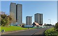
Bellsmyre High Flats
Click on the end-note title for other views.
In the present view, preparations for demolition are under way. The low building in front of the tower block on the right is the Cutty Sark Community Centre; it stands on the same site as the previous community centre, which had been called Howatshaws Hall, and which can be seen in an earlier view Image
See also Image, corresponding to the present picture, but taken almost a year later.
Image: © Lairich Rig
Taken: 23 Nov 2013
0.15 miles
8
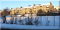
Valeview Terrace, Bellsmyre
The photograph was taken from Stirling Road, and shows the south-western edge of Bellsmyre.
Image: © Lairich Rig
Taken: 2 Dec 2010
0.15 miles
9
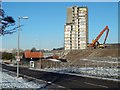
Bellsmyre High Flats: demolition in progress
The last to go was Kinglass House, shown here; compare Image The low building, left of centre, is the Cutty Sark Community Centre.
The present picture was taken on a Friday. The site of the flats is visible from hills in the area, so I was able to follow developments here while exploring other areas: on the Monday morning following, a stump of this building remained, but there was only a mound of rubble here by Wednesday (28th).
Image: © Lairich Rig
Taken: 19 Jan 2015
0.16 miles
10
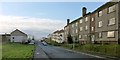
Aitkenbar Drive, Bellsmyre
The picture was taken from near the junction with Image Aitken Barr (or "Aitkenbarr") was the name of a farm that was located near here before the Bellsmyre estate existed.
The continuation of this road on the far side of Image is called Image; see that item for more details on the farm just mentioned.
Image: © Lairich Rig
Taken: 11 Jan 2013
0.16 miles