IMAGES TAKEN NEAR TO
Maryland Road, DUMBARTON, G82 3DH
Introduction
This page details the photographs taken nearby to Maryland Road, G82 3DH by members of the Geograph project.
The Geograph project started in 2005 with the aim of publishing, organising and preserving representative images for every square kilometre of Great Britain, Ireland and the Isle of Man.

There are currently over 7.5m images from over14,400 individuals and you can help contribute to the project by visiting https://www.geograph.org.uk
Image Map
Images are licensed for reuse under creativecommons.org/licenses/by-sa/2.0
Notes
- Clicking on the map will re-center to the selected point.
- The higher the marker number, the further away the image location is from the centre of the postcode.
Image Listing (33 Images Found)
Images are licensed for reuse under creativecommons.org/licenses/by-sa/2.0
Image
Details
Distance
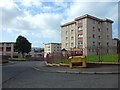
2
Howatshaws Road, Bellsmyre
The top of one of the High Flats at Bellsmyre can be seen in the background, left of centre; for those, see http://www.geograph.org.uk/snippet/8193
Image: © Lairich Rig
Taken: 11 Jan 2013
0.11 miles
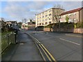
3
St Peter's RC Church, Bellsmyre
The church (built 1970-71; the architects are listed below) stands alongside Image, part of which appears in the foreground.
Image: © Lairich Rig
Taken: 11 Jan 2013
0.11 miles
5
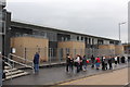
New Bellsmyre Campus
The new Bellsmyre Campus which opened on Tuesday 23rd August 2016. The campus comprises of Aitkenbar and St Peter's Primary Schools along with the new Bellsmyre Nursery.
Image: © Matt McFadzean
Taken: 23 Aug 2016
0.16 miles
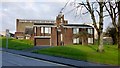
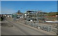
6
New Aitkenbar & St Peter's Primary School
The new joint campus for Aitkenbar and St Peter's Primary Schools. The new school presently under construction on the old St Peter's site located on Howatshaws Road will be ready for the start of the 2016/17 session.
Image: © Matt McFadzean
Taken: 27 Dec 2015
0.17 miles
7
Former site of Aitkenbar Primary School
The crossing at the left is shown from the other side of the road in Image
Housing will be built here. See Image for an earlier picture showing rubble on site, Image for the building that formerly stood here, and Image for its replacement.
Image: © Lairich Rig
Taken: 14 Nov 2019
0.17 miles
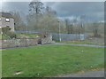
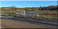
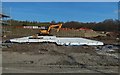
8
Former site of Aitkenbar Primary School
It is being developed for housing, and it is seen here across Howatshaws Road, at the junction with Whiteford Avenue. See Image for more information and links. For more of the area on the right, see Image
Image: © Lairich Rig
Taken: 22 Mar 2020
0.17 miles
9
Former site of Aitkenbar Primary School
It was taken on the same day as Image, with some of the same details visible. The site is being developed for housing; see Image for more information and for links.
Image: © Lairich Rig
Taken: 22 Mar 2020
0.17 miles
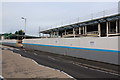
10

Construction on the Bellsmyre Campus
The site is adjacent to that of the new OLSP: Image
In the present picture, the finishing touches are being put on the Bellsmyre Campus; see also Image, taken on the same day.
Another contributor's pictures show it at the time of opening (two days later): Image (for more information) and Image (signage).
Image: © Lairich Rig
Taken: 21 Aug 2016
0.17 miles