IMAGES TAKEN NEAR TO
Carman View, DUMBARTON, G82 3AX
Introduction
This page details the photographs taken nearby to Carman View, G82 3AX by members of the Geograph project.
The Geograph project started in 2005 with the aim of publishing, organising and preserving representative images for every square kilometre of Great Britain, Ireland and the Isle of Man.

There are currently over 7.5m images from over14,400 individuals and you can help contribute to the project by visiting https://www.geograph.org.uk
Image Map
Images are licensed for reuse under creativecommons.org/licenses/by-sa/2.0
Notes
- Clicking on the map will re-center to the selected point.
- The higher the marker number, the further away the image location is from the centre of the postcode.
Image Listing (48 Images Found)
Images are licensed for reuse under creativecommons.org/licenses/by-sa/2.0
Image
Details
Distance
1
Merkins Avenue, Bellsmyre
The appearance of the buildings on this street has changed greatly in recent years. They looked very different about 30 years ago, when I passed through here more often.
Image: © Lairich Rig
Taken: 17 Jul 2017
0.09 miles
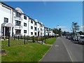
2
Valeview Terrace, Bellsmyre
The photograph was taken from Stirling Road, and shows the south-western edge of Bellsmyre.
Image: © Lairich Rig
Taken: 2 Dec 2010
0.09 miles
3

Entrance to Bellsmyre from Stirling Road
Stirling Road runs from left to right along the bottom of the image. The road leading uphill and then veering to the left is Bellsmyre Avenue. Just where it curves out of sight, Valeview Terrace branches off from it, to the left. The road leading off to the right (with a red car in it) is St Andrew's Brae.
Image: © Lairich Rig
Taken: 22 Oct 2008
0.15 miles
4
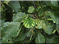
Leaf galls on common alder
The central leaf, with discoloured bulges, is affected by a mite, probably Acalitus brevitarsus. The lower surface (not shown here) is covered with what seems to be a creamy-coloured powdery mass, but is really a dense mass of hairs (called an erineum) whose growth is induced by the mites.
Image: © Lairich Rig
Taken: 12 Sep 2008
0.17 miles
5
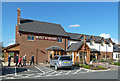
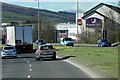
The Malt & Myre
This Brewers Fayre establishment lies at a convenient location for Loch Lomond road traffic.
Image: © Mary and Angus Hogg
Taken: 30 Apr 2013
0.18 miles
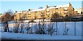
6
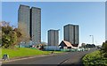
Bellsmyre High Flats
Click on the end-note title for other views.
In the present view, preparations for demolition are under way. The low building in front of the tower block on the right is the Cutty Sark Community Centre; it stands on the same site as the previous community centre, which had been called Howatshaws Hall, and which can be seen in an earlier view Image
See also Image, corresponding to the present picture, but taken almost a year later.
Image: © Lairich Rig
Taken: 23 Nov 2013
0.18 miles
7
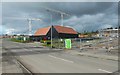
Construction on new OLSP site
This was formerly the location of the Bellsmyre High Flats: Image The new OLSP (Our Lady and St Patrick's High School) is being built here; see also Image
The building already standing is the Cutty Sark Community Centre. It is not a part of the new OLSP construction; rather, it was built, not long before the high flats were demolished, as a replacement for the previous community centre, Howatshaws Hall, which stood on the same spot.
Image: © Lairich Rig
Taken: 21 Aug 2016
0.18 miles
8
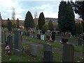
Dumbarton Cemetery
Dumbarton Cemetery with the Kilpatrick Hills beyond.
Image: © Andrew McEwan
Taken: 27 Nov 2005
0.18 miles
9

Dumbarton, River Leven and River Clyde from the air
Looking over the Bellsmyre tower blocks to Bonhill Road, Dumbarton Rock and the rivers Clyde and Leven. Langbank is visible on the south bank of the Clyde. Viewed from a Glasgow bound flight from Newark, USA.
Image: © Thomas Nugent
Taken: 15 Jul 2011
0.18 miles