IMAGES TAKEN NEAR TO
Milton Brae, DUMBARTON, G82 2TU
Introduction
This page details the photographs taken nearby to Milton Brae, G82 2TU by members of the Geograph project.
The Geograph project started in 2005 with the aim of publishing, organising and preserving representative images for every square kilometre of Great Britain, Ireland and the Isle of Man.

There are currently over 7.5m images from over14,400 individuals and you can help contribute to the project by visiting https://www.geograph.org.uk
Image Map
Images are licensed for reuse under creativecommons.org/licenses/by-sa/2.0
Notes
- Clicking on the map will re-center to the selected point.
- The higher the marker number, the further away the image location is from the centre of the postcode.
Image Listing (31 Images Found)
Images are licensed for reuse under creativecommons.org/licenses/by-sa/2.0
Image
Details
Distance
1
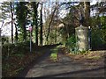
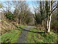
Path from Milton Brae
The picture was taken from the point where the path starts; it branches off from the side of the road, which is called Milton Brae.
The path, part of a route called the Crags Circular Path, heads in this direction (WNW) for about 120 metres, before turning to head SSW (see, for example, Image). It eventually meets the A82: see Image and Image The route of the path is marked on the 1:25000 map.
(Note that the Crags Circular Path itself is considerably longer; see http://www.geograph.org.uk/tagged/the+crags+circular+path#photo=5309264 for a selection of photographs along that route.)
The gatepost on the right is one of a pair flanking the driveway to a house. There is a cut bench mark on it, though it is a little overgrown: Image
Just to the left of the photographer's position, and out of shot, was a flyer (one of several in the area) protesting against a proposal to slice a huge chunk off the top of Dumbuck Hill. The local planning committee had rejected the proposal, but the quarry operators had appealed to the Scottish Government. This flyer (like the other copies) had recently been modified to celebrate the Scottish Government's decision to reject that appeal.
Image: © Lairich Rig
Taken: 1 Mar 2017
0.07 miles
2
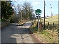
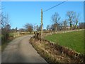
The Crags Circular Path leaving Milton Brae
Milton Brae is the road that leads straight ahead, in the left-hand side of the photograph.
The road branching off to the right is shown in Image; it leads to that farm and to Riggangower Quarry Landfill Site; however, the Crags Circular Path, a route for pedestrians and cyclists, leads partway along that road; see Image for further details.
Image: © Lairich Rig
Taken: 2 Apr 2010
0.07 miles
3
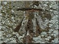
Cut bench mark at Milton Brae
I noticed it in passing, despite its poor condition; it is on the large gatepost that is shown on the right in Image
According to the OS database, it is a 3rd-order cut bench mark, 22.361 metres above Newlyn datum.
Image: © Lairich Rig
Taken: 28 Aug 2018
0.09 miles
4
Path from Milton Brae
The path is the one shown in Image, but the present view is from about 100 metres farther on, and is in the opposite direction. On the right is an object like a trough, but much smaller; it is overflowing.
Image: © Lairich Rig
Taken: 1 Mar 2017
0.10 miles
5
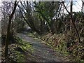
Path to Milton Brae
The path, part of a route called the Crags Circular Path, is a continuation of the one shown heading off to the left in Image
In the area shown in the present picture, the path has left the houses behind. There is a field to the left, behind the trees. To the right (east) of the path, the ground, greatly overgrown, slopes down to the course of the Milton Burn. The Milton Printworks used to stand on the other side of the burn.
For a view in the opposite direction from a point about 100 metres ahead, see Image
Image: © Lairich Rig
Taken: 1 Mar 2017
0.13 miles
6
The Crags Circular Path
Middleton Farm is behind trees on the right. The view is from a little farther along the road that is shown branching off to the right, leading uphill, in Image
Image: © Lairich Rig
Taken: 27 Jan 2017
0.15 miles
7
The Crags Circular Path at Milton
This part of the road is between Milton Brae (see Image) and the Image There is a gas pipeline marker in the right foreground. Image is in the background.
Image: © Lairich Rig
Taken: 9 Mar 2018
0.16 miles
8
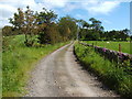
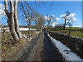
Track to Greenland Farm
This section of the farm track is part of a much longer route called the Crags Circular Path; specifically, the section of the track that is also part of that route is the one between the points shown in Image and Image
Image: © Lairich Rig
Taken: 23 Jun 2011
0.17 miles
9
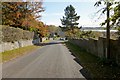
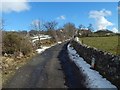
Milton Brae
Milton Brae is the name of the road. This is a view downhill; the River Clyde can be seen in the background.
For a view uphill from about 200 metres further down the road, see Image, which also mentions a few features that can be seen alongside the road.
Image: © Lairich Rig
Taken: 26 Oct 2012
0.17 miles
10
The Crags Circular Path at Milton
The subject is as in Image, but the view is from further ahead. Only the nearest ten metres or so of the track are in the same grid square as the photographer.
Image: © Lairich Rig
Taken: 9 Mar 2018
0.18 miles