IMAGES TAKEN NEAR TO
Dumbarton Road, DUMBARTON, G82 2TD
Introduction
This page details the photographs taken nearby to Dumbarton Road, G82 2TD by members of the Geograph project.
The Geograph project started in 2005 with the aim of publishing, organising and preserving representative images for every square kilometre of Great Britain, Ireland and the Isle of Man.

There are currently over 7.5m images from over14,400 individuals and you can help contribute to the project by visiting https://www.geograph.org.uk
Image Map
Images are licensed for reuse under creativecommons.org/licenses/by-sa/2.0
Notes
- Clicking on the map will re-center to the selected point.
- The higher the marker number, the further away the image location is from the centre of the postcode.
Image Listing (72 Images Found)
Images are licensed for reuse under creativecommons.org/licenses/by-sa/2.0
Image
Details
Distance
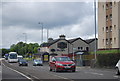
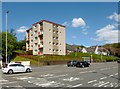
3
The Crags Circular Path at Milton
The path shown branching off to the right from the Image leads to the point, beside the A82, from which this picture was taken. That path and its continuation on the other side of the road are part of a route called the Crags Circular Path.
On the other side of the road, the route follows the short section of road that leads uphill, and then turns to the right (as shown in Image), continuing as a signposted path, mostly through woodland, to emerge on Milton Brae. For the other end of the path, see Image
Image: © Lairich Rig
Taken: 1 Mar 2017
0.01 miles
5
The main road through Milton
On the other side of Dumbarton Road is Crannog Court; the name is a reference to Dumbuck Crannog: http://www.geograph.org.uk/snippet/43
Image: © Lairich Rig
Taken: 24 May 2013
0.03 miles
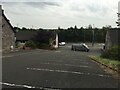
6
Path from Milton Brae
This is the reverse of the view in Image The trees and lamp post that appear on the left in that picture can be seen directly ahead in the present photograph.
The path is part of a route called the Crags Circular Path. Followed in this direction, it turns left, not far ahead, to follow a short section of road downhill to meet (and cross) the A82, as shown in Image
Image: © Lairich Rig
Taken: 1 Mar 2017
0.03 miles
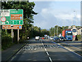
7
The Crags Circular Path at Milton
This short path leads from the cycle route to the A82. The Crags Circular Path continues on the other side of that road: Image
For a view in the opposite direction along the path, see Image
Image: © Lairich Rig
Taken: 21 Apr 2017
0.03 miles
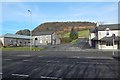
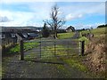
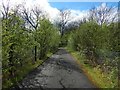
8
Path to Milton Brae
Another photograph, Image, shows a short section of road leaving the A82 to lead uphill. The present picture is taken from the top of that road.
As mentioned in the description for that picture, a route called the Crags Circular Path follows that road to this point, and then continues in the form of a path. That path passes the gate that can be seen not far ahead, and then continues directly ahead, beyond the left-hand side of the gate.
(For a view from that gate, looking back to the point from which the present picture was taken, see Image)
The houses on the right are on Image, but the Crags Circular Path does not follow that road; it instead follows a route between the houses and the field on the left.
Image: © Lairich Rig
Taken: 1 Mar 2017
0.03 miles
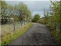
10
The Crags Circular Path at Milton
The same path is shown, viewed in the opposite direction, in Image
Followed in the direction shown in the present picture, it leads to the junction shown in Image; the path is shown entering from the right in that picture.
Image: © Lairich Rig
Taken: 21 Apr 2017
0.06 miles