IMAGES TAKEN NEAR TO
Milton, DUMBARTON, G82 2SG
Introduction
This page details the photographs taken nearby to G82 2SG by members of the Geograph project.
The Geograph project started in 2005 with the aim of publishing, organising and preserving representative images for every square kilometre of Great Britain, Ireland and the Isle of Man.

There are currently over 7.5m images from over14,400 individuals and you can help contribute to the project by visiting https://www.geograph.org.uk
Image Map
Images are licensed for reuse under creativecommons.org/licenses/by-sa/2.0
Notes
- Clicking on the map will re-center to the selected point.
- The higher the marker number, the further away the image location is from the centre of the postcode.
Image Listing (26 Images Found)
Images are licensed for reuse under creativecommons.org/licenses/by-sa/2.0
Image
Details
Distance
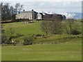
1
Middleton Farm
A small farmhouse near Milton.
Image: © Stephen Sweeney
Taken: 4 Jan 2007
0.02 miles
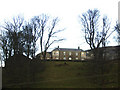
2
Possible site of Old Chapel of Colquhoun
A knoll, crossed by a fence, is visible in the middle distance; a few low grass-covered remains of walls are present on the part of the ridge to the left of the fence. See https://canmore.org.uk/site/43251/old-chapel-of-colquhoun (at Canmore) for a description of the ruins that are visible there, and for some relevant references.
This is about as good a view of that part of the knoll as can be obtained without leaving the road; from the section of the road that is nearer to the ruins, the view is obscured by trees.
The building in the background is Image
Image: © Lairich Rig
Taken: 2 Apr 2010
0.10 miles
3
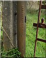
Metal gatepost: detail
See Image for context; this gatepost is on the left in that picture. The writing is legible, but is reproduced here for the benefit of text searches: "A & J Main & Co Ltd, Glasgow, London & Dublin".
The firm had its beginning in the middle of the nineteenth century, but it was wound up in 1968. Glasgow University has a page on it: https://www.mackintosh-architecture.gla.ac.uk/catalogue/name/?nid=MainAJCo
Image: © Lairich Rig
Taken: 4 Oct 2019
0.12 miles
4
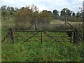
Gate beside the road
The road is Milton Brae, and the gate is on its eastern side. The metal gatepost on the left bears the manufacturer's name: "A & J Main & Co"; see Image for more on that.
Image: © Lairich Rig
Taken: 4 Oct 2019
0.12 miles
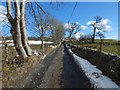
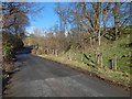
5
The Crags Circular Path at Milton
This part of the road is between Milton Brae (see Image) and the Image There is a gas pipeline marker in the right foreground. Image is in the background.
Image: © Lairich Rig
Taken: 9 Mar 2018
0.14 miles
6
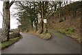
Road junction
The private road on the right leads to Middleton Farm and Treedom Cottage.
Image: © Richard Sutcliffe
Taken: 25 Jan 2019
0.14 miles
7
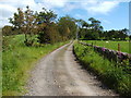
Track to Greenland Farm
This section of the farm track is part of a much longer route called the Crags Circular Path; specifically, the section of the track that is also part of that route is the one between the points shown in Image and Image
Image: © Lairich Rig
Taken: 23 Jun 2011
0.14 miles
8
The Crags Circular Path at Milton
The subject is as in Image, but the view is from further ahead. Only the nearest ten metres or so of the track are in the same grid square as the photographer.
Image: © Lairich Rig
Taken: 9 Mar 2018
0.14 miles
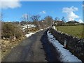
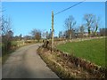
9
Milton Brae
Milton Brae is the name of the road. Visible not far ahead is a bridge over the Milton Burn. There are some unmarked concrete posts beside the road here (two can be seen in the right foreground); there are others beyond the bridge, on the same side of the road, but they cannot be seen from here.
Image: © Lairich Rig
Taken: 23 Mar 2018
0.15 miles
10
The Crags Circular Path
Middleton Farm is behind trees on the right. The view is from a little farther along the road that is shown branching off to the right, leading uphill, in Image
Image: © Lairich Rig
Taken: 27 Jan 2017
0.15 miles