IMAGES TAKEN NEAR TO
Glen Esk Gardens, DUMBARTON, G82 2NW
Introduction
This page details the photographs taken nearby to Glen Esk Gardens, G82 2NW by members of the Geograph project.
The Geograph project started in 2005 with the aim of publishing, organising and preserving representative images for every square kilometre of Great Britain, Ireland and the Isle of Man.

There are currently over 7.5m images from over14,400 individuals and you can help contribute to the project by visiting https://www.geograph.org.uk
Image Map
Images are licensed for reuse under creativecommons.org/licenses/by-sa/2.0
Notes
- Clicking on the map will re-center to the selected point.
- The higher the marker number, the further away the image location is from the centre of the postcode.
Image Listing (73 Images Found)
Images are licensed for reuse under creativecommons.org/licenses/by-sa/2.0
Image
Details
Distance
1
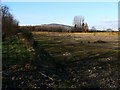
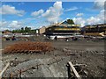
Waste ground
This area of waste ground, formerly the site of bonded warehouses, will be built upon as part of Lomondgate, a mixed-use development on a 106 acre site. See Image for a view in the opposite direction over the same area.
Dumbarton Golf Course lies beyond the boundary at the left-hand edge of the picture. Carman Hill (Image) and the muirs to its north are visible in the background.
Image: © Lairich Rig
Taken: 1 Feb 2012
0.05 miles
3
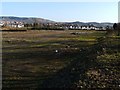
Waste ground
This area of waste ground, formerly the site of bonded warehouses, will be built upon as part of Lomondgate, a mixed-use development on a 106 acre site. Other parts of that development can be seen in this photograph: the houses visible right of centre were recently built, or are still under construction.
The more distant built-up area at the far left is Bellsmyre. The embankment at the right-hand edge of the picture corresponds to the boundary of Dumbarton Golf Course.
See Image for a view in the opposite direction over the same area.
Image: © Lairich Rig
Taken: 1 Feb 2012
0.08 miles
5
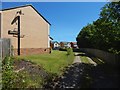
Path leading into Lomondgate housing
A path, shown in Image, leads here, and thus into the housing at Lomondgate. The house in the left foreground is the one that is shown at the far right in the other picture.
At the time the present picture was taken, this was the western edge of the occupied housing at Lomondgate, but new houses were being built, extending the development westwards towards the River Leven: see Image, taken from the same place as the present picture, but looking in the opposite direction. See Image for another view.
Image: © Lairich Rig
Taken: 24 Jun 2018
0.10 miles
6
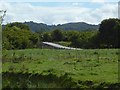
Works access for cable replacement
The view is from the other side of the Murroch Burn, part of whose steep bank can be seen in the foreground. Dumbowie Hill is in the background.
See Image for a later, nearer view.
Image: © Lairich Rig
Taken: 3 Sep 2020
0.12 miles
7
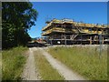
Construction at Lomondgate
The view is from about the same place as Image, but is in the opposite direction. As noted there, the area of housing is being extended to the west.
Image: © Lairich Rig
Taken: 24 Jun 2018
0.12 miles
8
Construction at Lomondgate
The built-up area is extending westwards.
Image: © Lairich Rig
Taken: 18 Mar 2018
0.13 miles
9
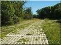
Walkway leading from SUDS pond
The walkway leads from a Image, and is made of the same material as Image It leads towards the site of the Lomondgate development.
Compare Image
A later picture corresponds almost exactly with the present view, except that the trees to the left have been cleared, greatly altering the appearance of the area: Image
Image: © Lairich Rig
Taken: 17 Jun 2010
0.13 miles
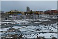
10
Construction at Lomondgate
Housing developments first occupied the cleared area shown in Image, and then advanced to the west, as shown here.
Image: © Lairich Rig
Taken: 13 May 2018
0.13 miles