IMAGES TAKEN NEAR TO
Round Riding Road, DUMBARTON, G82 2JB
Introduction
This page details the photographs taken nearby to Round Riding Road, G82 2JB by members of the Geograph project.
The Geograph project started in 2005 with the aim of publishing, organising and preserving representative images for every square kilometre of Great Britain, Ireland and the Isle of Man.

There are currently over 7.5m images from over14,400 individuals and you can help contribute to the project by visiting https://www.geograph.org.uk
Image Map
Images are licensed for reuse under creativecommons.org/licenses/by-sa/2.0
Notes
- Clicking on the map will re-center to the selected point.
- The higher the marker number, the further away the image location is from the centre of the postcode.
Image Listing (131 Images Found)
Images are licensed for reuse under creativecommons.org/licenses/by-sa/2.0
Image
Details
Distance
1
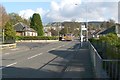
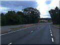
Round Riding Road
The photograph was taken near the eastern end of the road, where it meets the A82, at the foot of Garshake Road.
Round Riding Road follows the same line as a road shown on the first-edition OS map (c.1860), although there were only a few buildings alongside it at that time. The road is not named on that map, but other writings of the time show that it was then called Roundredding Road. Very similar spellings of the name appear on earlier maps from the 1740s to the 1820s (see http://www.geograph.org.uk/article/Dumbarton-Cemetery#the-location for the details).
The Pont/Blaeu map of the Lennox (published in 1654, but based on surveys carried out in the 1580s-90s) shows a "Barundridain" here. That name is presumably the ancestor of the later forms "Roundredding" and "Round Riding".
Returning to what is visible in the photograph, the turning for Kilpatrick View is just ahead, on the left. The escarpment visible in the background is Image The distant area of housing, located on the slopes in front of the escarpment, just left of centre, is the eastern end of Bellsmyre (compare, for example, Image).
On the right, between the pavement and the houses, is a fenced-off area, where a burn flows parallel to the road (and towards the photographer's position). It is not named on the map, but is the Knowle Burn, which had formed the eastern boundary of the medieval burgh.
For a view in the opposite direction along the same road, see Image
Image: © Lairich Rig
Taken: 1 Nov 2011
0.03 miles
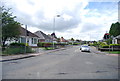
3
Houses on Dumbuck Road, Dumbarton
Houses on Dumbuck Road in Dumbarton, part of West Dunbartonshire, Scotland. Seen here from Stirling Road. You will notice the "Yes" flyers in the windows for the forthcoming Scottish independence referendum.
Image: © Steven Haslington
Taken: 12 Sep 2014
0.08 miles
4
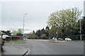
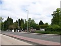
A82 road junction at Silverton
A82 junction with Round Riding Road
Image: © John Firth
Taken: 11 May 2012
0.08 miles
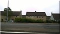
6
Stirling Road at West Dunbartonshire Council Offices
West Dunbartonshire Council's offices are visible straight ahead. There is an entrance to Dumbarton Cemetery on the left.
Image: © Richard Cooke
Taken: 9 Apr 2016
0.09 miles
7
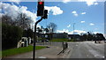
Entrance to the cemetery from the A82
Image: © Elliott Simpson
Taken: 1 Jun 2013
0.10 miles
8
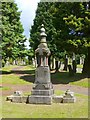
The Oddfellows' Monument
"Loyal Dixon Lodge No. 1901, Dumbarton District of the Independent Order of Oddfellows, M.U., and dedicated to the members of the Past Grand Lodge in trust, 15th September 1900. / Erected by Ex-Bailie George Bell, P.P.G.M. Dumbarton District."
[M.U.: Manchester Unity; P.P.G.M.: Past Provincial Grand Master.]
This particular branch of the Oddfellows was the earliest of the so-called Friendly Societies to appear in the Dumbarton area. It was instituted there in 1839. By 1881, it had a local membership of about 357.
Such organisations might acquire a plot in the cemetery, marked by a monument, to ensure that any of their members who died, and who had been needy or who had no surviving relatives to take care of such matters, might be sure of having a burial place. Compare the Image, located elsewhere in the same cemetery; the accompanying description names similar organisations that had a presence in the district.
Before this memorial was erected, there was already a more prominent landscape feature associated with the Oddfellows: a flagstaff on the top of Dumbuck Hill (this was before quarrying work began eating away at the hill); see Image for more on the flagstaff and the occasion of its presentation.
For more on the George Bell named on this memorial, and for his ancestry, see Image
Image: © Lairich Rig
Taken: 24 Jun 2011
0.10 miles
9

Round Riding Road
The same road is shown in Image; see that item for further information. The present photograph is a view in the opposite direction, and the next turning on the left is for Miller Court. In the fenced-off area to the left, between pavement and houses, the Knowle Burn flows parallel to the road.
Image: © Lairich Rig
Taken: 1 Nov 2011
0.10 miles
10
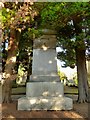
The McMillan Monument
The photograph does not really convey the scale of the structure, but this gray granite memorial is about 15 feet high. It is located near the main entrance of the cemetery, and it was designed by the town architect, John McLeod (Image), and executed by Mossman & Wishart of Glasgow.
On the upper part of the monument can be seen the McMillan crest (which features two hands wielding a sword) and the McMillan motto: "Miseris Succurrere Disco" (the sense of which is "I learn [or aspire] to help the unfortunate").
The main inscription begins as follows: "John and Jane McMillan, sacred to the memory of Thomas Dunlop Douglas, their son, born March 1850, died Aug 1870. Archibald their son, born Nov 1842, died Jun 1875. Jane Gow, their mother (wife of John McMillan, College Park, Dumbarton), born 25th May 1816, died 4th December 1884."
For all its size, the memorial is easily overlooked in its shaded location, but it is worth showing and describing here in connection with the town's industrial heritage: the McMillans were one of the great shipbuilding families of Dumbarton.
John McMillan senior, who is named in the inscription, died at his College Park residence on 21st September 1891, aged 76 (College Park is the area where Image were later built). At his death, John was the oldest shipbuilder on the Clyde. He was the son of Archibald McMillan; Archibald's own memorial is not in this cemetery, but is one of the few that remain in the greatly-reduced kirkyard of the parish church: Image
Archibald and John founded their shipbuilding firm, Archibald McMillan & Son, in 1834. (It was this same John who, with his friend Peter Denny, presented Levengrove Park to the town; see http://www.geograph.org.uk/snippet/5911 for details.)
John McMillan junior, was the third son of the above John McMillan. He was born on the 28th August, 1848, and died on the 2nd of December, 1888, a few years before his father, at the much younger age of forty.
A good summary of the lives of the elder and younger John McMillan can be found in the first chapter of Donald MacLeod's "Dumbarton: Its Recent Men and Events" (1898); at the start of that chapter is a portrait of the elder John McMillan.
Image: © Lairich Rig
Taken: 10 Dec 2012
0.11 miles