IMAGES TAKEN NEAR TO
Gooseholm Crescent, DUMBARTON, G82 2AR
Introduction
This page details the photographs taken nearby to Gooseholm Crescent, G82 2AR by members of the Geograph project.
The Geograph project started in 2005 with the aim of publishing, organising and preserving representative images for every square kilometre of Great Britain, Ireland and the Isle of Man.

There are currently over 7.5m images from over14,400 individuals and you can help contribute to the project by visiting https://www.geograph.org.uk
Image Map
Images are licensed for reuse under creativecommons.org/licenses/by-sa/2.0
Notes
- Clicking on the map will re-center to the selected point.
- The higher the marker number, the further away the image location is from the centre of the postcode.
Image Listing (41 Images Found)
Images are licensed for reuse under creativecommons.org/licenses/by-sa/2.0
Image
Details
Distance
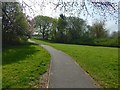
1
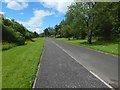
Path between underpasses
For a view from near the far end of the path, and for more information, see Image Particularly at that end, an area to the left (south-west) of the path has been left unmown; the unmown area also extends a little further to north-west, alongside Stirling Road.
That area provides a useful habitat for plants; I observed several Common Spotted-orchids growing there.
For a view in the opposite direction from about the same place, see Image
Image: © Lairich Rig
Taken: 4 Jun 2017
0.09 miles
2

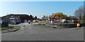
Demolition of Langcraigs residential care home
Compare the equivalent scene three weeks earlier: Image A new care home is to be built on this site.
Image: © Lairich Rig
Taken: 10 May 2019
0.09 miles
3
Demolition of Langcraigs residential care home
Compare the equivalent view three weeks later: Image The other side was still largely intact: Image A new care home is to be built on this site.
Image: © Lairich Rig
Taken: 19 Apr 2019
0.09 miles
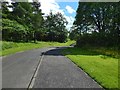
4
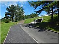
Path between underpasses
The steps directly ahead lead up to the pavement beside Stirling Road. The underpass beside those steps (shown in Image) leads under that road, emerging beside St Andrew's Brae, at the foot of Bellsmyre.
For a view from further back, for more context, see Image
Followed in the opposite direction (Image), the path leads to and through a similar underpass (below the A82) to emerge at Barloan Place.
Image: © Lairich Rig
Taken: 7 Jun 2017
0.10 miles
5
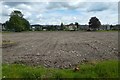
Cleared site of Langcraigs Care Home
This is the scene after the completion of the work shown taking place in Image / Image See Image for a view from a different angle.
Image: © Lairich Rig
Taken: 9 Jun 2019
0.10 miles
6
Path behind Langcraigs Care Home
Image: © Lairich Rig
Taken: 24 Apr 2019
0.10 miles
8

Langcraigs Care Home
When this picture was taken, demolition had already begun, although not yet apparent from this side. Compare Image and Image, taken from the other side.
Image: © Lairich Rig
Taken: 24 Apr 2019
0.10 miles
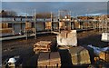
9

Cleared site of Langcraigs Care Home
A pile driver is on site. The view is from beside the main road (Townend Road); see Image for a view from the other side. The building that formerly stood here is shown in Image
Image: © Lairich Rig
Taken: 1 Sep 2019
0.10 miles
10
Path between underpasses
The subject is as in Image, but the view is in the opposite direction. In the present picture, the path heads right, into an underpass below the A82. From there, it emerges at Barloan Place.
Image: © Lairich Rig
Taken: 4 Jun 2017
0.10 miles