IMAGES TAKEN NEAR TO
Station Road, DUMBARTON, G82 1PW
Introduction
This page details the photographs taken nearby to Station Road, G82 1PW by members of the Geograph project.
The Geograph project started in 2005 with the aim of publishing, organising and preserving representative images for every square kilometre of Great Britain, Ireland and the Isle of Man.

There are currently over 7.5m images from over14,400 individuals and you can help contribute to the project by visiting https://www.geograph.org.uk
Image Map
Images are licensed for reuse under creativecommons.org/licenses/by-sa/2.0
Notes
- Clicking on the map will re-center to the selected point.
- The higher the marker number, the further away the image location is from the centre of the postcode.
Image Listing (299 Images Found)
Images are licensed for reuse under creativecommons.org/licenses/by-sa/2.0
Image
Details
Distance
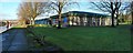
1
Dumbarton Health Centre
The rear of the health centre is seen here from across the River Leven, with part of Image visible on the left. The rear of the building is also shown in Image
The area now occupied by the health centre was formerly the location of the town's glassworks (on which, see Image). The glassworks were demolished in 1850; from then until the 1960s, there was an engine works here.
Image: © Lairich Rig
Taken: 27 Jul 2012
0.01 miles
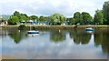
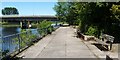
2
Riverside walkway
This is a similar view to Image; see that item for further historical details. The present photograph was taken a little further north along the route, just after passing under Image; the railway bridge which crosses the River Leven between Dalreoch and Dumbarton Central stations can be seen in the background.
To the right of the path, the rear of Image can be seen. The benches, like others located just to the south (again, see Image), commemorate the Queen's Silver Jubilee.
As the photograph shows, the path becomes grassy not far ahead. For a view of the next section of the route, taken from just beyond the railway bridge, see Image
Image: © Lairich Rig
Taken: 17 Jun 2010
0.02 miles
3
Riverside walkway
The viewpoint is similar to that for Image, but the present picture, taken with a very low winter sun, is a wide-angle view, so as to fully include Image on the right. Image is a little further ahead on the left.
As the present picture shows, the wooden parts of all of the "Silver Jubilee" benches (they are shown intact in the earlier picture of the walkway – see the previous paragraph for the link) have now been removed.
Image: © Lairich Rig
Taken: 3 Jan 2015
0.02 miles
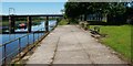
4
Riverside walkway
This is a view along part of a footpath that leads along the eastern bank of the River Leven; it leads north to Kilmalid, at which point, after passing through a Image, the path leads away from the river.
The present photograph was taken at the southern end of the route, where it begins beside some government offices, as shown in Image The nearer of the bridges in the background is Image See Image for a similar view, but taken from a point just beyond that bridge.
This area is part of a quayside that served a glassworks. Only a few of the original cobbles can be seen here, behind the benches, but more are visible just to the south: Image
Image: © Lairich Rig
Taken: 17 Jun 2010
0.03 miles
5
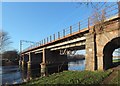
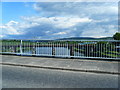
Dumbarton Railway Bridge
For another contributor's earlier image of the bridge, see Image (which was also the first photograph submitted for this OS grid square).
Image: © Lairich Rig
Taken: 3 Jan 2015
0.05 miles
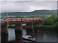
7
Dumbarton Railway Bridge
The picture was taken on the same day as Image, but from a higher viewpoint, on the Image
A cycle route can be seen on the left, and Image on the right. The railway bridge remained in normal use, but scaffolding had been erected along its length, on both the near and the far side. Just beyond the right-hand half of the bridge is a Image: see Image
The rightmost third of the skyline is taken up by the Long Crags.
Image: © Lairich Rig
Taken: 18 Nov 2016
0.05 miles
8
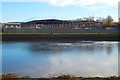
Storage building under construction
The view is from the other side of the Leven. A single-storey 2700m² storage facility is shown under construction at the south-western corner of the Broadmeadow Industrial Estate; the building is for a company that are contract packers for the drinks industry, Scotch whisky in particular.
The site is beside a railway bridge, as shown by another picture: Image
Image: © Lairich Rig
Taken: 18 Nov 2016
0.06 miles
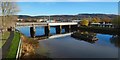
9
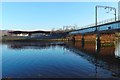
Railway bridge and new storage building
On the left is a Image; see that item for further details. By the time the present picture was submitted, the near end-wall, not present when the picture was taken, had been erected.
The railway bridge is shown from the other side, about two weeks earlier, in Image Note that, when that picture was taken, the strip of white material on that side was only half-complete (see below for explanation).
I was unable to find any information about the work that was being carried out on the railway bridge, but the setup here was at least consistent with refurbishment work where the metalwork of the bridge is grit-blasted and then painted.
Scaffolding had been erected, and strings of lights set up, along both sides of the bridge. Temporary enclosed passages, illuminated by those lights, were then created; the strip of white material that can be seen on the side of the bridge in this picture is the outside of one of those enclosures.
When these were complete, as they are in the picture, they were then connected, at the far end of the bridge, and by means of a large flexible tube, to an industrial vacuum pump that was set just in front of the storage building's construction site.
Image: © Lairich Rig
Taken: 4 Dec 2016
0.06 miles