IMAGES TAKEN NEAR TO
Bridge Street, DUMBARTON, G82 1NY
Introduction
This page details the photographs taken nearby to Bridge Street, G82 1NY by members of the Geograph project.
The Geograph project started in 2005 with the aim of publishing, organising and preserving representative images for every square kilometre of Great Britain, Ireland and the Isle of Man.

There are currently over 7.5m images from over14,400 individuals and you can help contribute to the project by visiting https://www.geograph.org.uk
Image Map
Images are licensed for reuse under creativecommons.org/licenses/by-sa/2.0
Notes
- Clicking on the map will re-center to the selected point.
- The higher the marker number, the further away the image location is from the centre of the postcode.
Image Listing (426 Images Found)
Images are licensed for reuse under creativecommons.org/licenses/by-sa/2.0
Image
Details
Distance
1
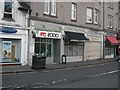
Shops, Bridge Street
A refreshingly retro computer shop on Bridge Street.
Image: © Richard Webb
Taken: 1 Jan 2009
0.00 miles
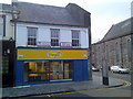
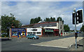
2
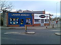
Shops on Bridge Street
At the corner of Bridge Street and High Street.
Image: © Stephen Sweeney
Taken: 25 Nov 2007
0.01 miles
3
Bridgend House
On High Street, between the old and new bridges.
Image: © Thomas Nugent
Taken: 21 Aug 2010
0.02 miles
4
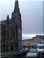
Church on Dumbarton High Street
One of many churches in the Dumbarton area.
Image: © Stephen Sweeney
Taken: 25 Nov 2007
0.02 miles
5
Gossip Shop(?!), Dumbarton High Street
Actually a coffee shop, I've since discovered.
Image: © Stephen Sweeney
Taken: 25 Nov 2007
0.03 miles
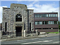
6
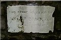
Foundation stone, former Salvation Army citadel
This is one of three surviving foundation stones visible at the front of Image, which was originally built as a Salvation Army citadel. See that link for further information.
The names on the other stones are those of a Miss Whyte and a Major Cockburn, but the inscriptions are otherwise the same. In the photograph whose link is given above, the three foundation stones can be seen as white stones in the darker low boundary wall at the front of the building; the present photograph shows the middle stone.
Image: © Lairich Rig
Taken: 5 Jan 2012
0.03 miles
7
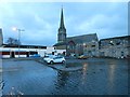
Flooding at Riverside Lane
The picture was taken at around sunset. Riverside Lane, the road that would normally be visible in the foreground, is flooded, although not so badly as it was a few days earlier; see Image for a view of the area behind the photographer's position, and Image for more information.
In the present view, the steeple is that of the Image
Image: © Lairich Rig
Taken: 6 Jan 2014
0.03 miles
8
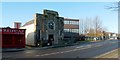
Bridgend House
For a different and earlier view, see Image
When the present picture was taken, the building served as the local office of the Citizens Advice Bureau (see end-note). However, it was originally built as a Salvation Army citadel.
Note the three white stones that can be seen in the low boundary wall at the front of the building; these are foundation stones, laid by local dignitaries. One of them reads: "This stone was laid by Walter Brock Esq. 28th August 1937". The others have the same inscription, but with the names "Miss C.H.Whyte" (or E.H.Whyte – the inscription is rather worn) and "Major David Cockb[urn]" (only part of his surname remains legible). See Image for a view of one of the stones.
By 1937, the Salvation Army had been present in Dumbarton for 47 years, but during that period they had moved from place to place within the town. The hall would provide them with more suitable premises; it was designed to accommodate 250 people.
The stone-laying ceremony was presided over by Colonel W Booth Davey. The first of the four foundation stones was laid by a Miss Thompson of Oakbank, who was acting on behalf of the wife of Walter Brock (see next), she being indisposed on the day. The other three stones were laid by Walter Brock of Leabank (see Image for that family), by Miss Whyte of Barnhill (Image), and by Major Cockburn. The hall itself cost £2605 4s, considerably more than the original estimate of £874. It opened in the spring of 1938, and only ceased to be used by the Salvation Army as recently as 2007.
The day of the stone-laying ceremony was an eventful one for Dumbarton, since it also saw the unveiling of a memorial to Robert Bontine Cunninghame Graham at a knoll called Arthur's Seat, about 1 km to the WNW: see Image for the details.
[Regarding the name "Citizens Advice Bureau": there is no apostrophe in the name of the organisation; I mention this only in case it is mistakenly corrected as a typo.]
Image: © Lairich Rig
Taken: 5 Jan 2012
0.03 miles
9
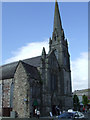
Former High Church
A Category B listed building on High Street by the old bridge. Built in 1863 to a design by John Honeyman. Now a shopping and leisure centre.
Image: © Thomas Nugent
Taken: 21 Aug 2010
0.03 miles
10
High Street
Bridge Street and the old bridge is to the left.
Image: © Thomas Nugent
Taken: 21 Aug 2010
0.03 miles