IMAGES TAKEN NEAR TO
Castlegreen Street, DUMBARTON, G82 1JU
Introduction
This page details the photographs taken nearby to Castlegreen Street, G82 1JU by members of the Geograph project.
The Geograph project started in 2005 with the aim of publishing, organising and preserving representative images for every square kilometre of Great Britain, Ireland and the Isle of Man.

There are currently over 7.5m images from over14,400 individuals and you can help contribute to the project by visiting https://www.geograph.org.uk
Image Map
Images are licensed for reuse under creativecommons.org/licenses/by-sa/2.0
Notes
- Clicking on the map will re-center to the selected point.
- The higher the marker number, the further away the image location is from the centre of the postcode.
Image Listing (66 Images Found)
Images are licensed for reuse under creativecommons.org/licenses/by-sa/2.0
Image
Details
Distance
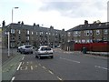
1
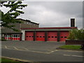
Dumbarton Fire Station
On Castlegreen St.
Image: © Stephen Sweeney
Taken: 11 May 2007
0.09 miles
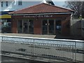
2
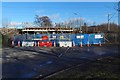
Road closed under a railway bridge
The bridge carries the railway line over Castlegreen Street; the nearest station is Dumbarton East.
The road heading off to the right leads to a sewage works: Image Those carrying out the work on the bridge were based nearby, beside the Image
Image: © Lairich Rig
Taken: 9 Feb 2018
0.10 miles
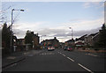
4
Traffic Lights on Glasgow Road
The A814 diverges from the A82 close to the Dumbuck Quarry near Milton. It heads west through Dumbuck, and the eastern suburbs of Dumbarton as Glasgow Road.
Image: © David Dixon
Taken: 26 Sep 2019
0.10 miles
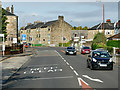
5
Greenhead Road at Glasgow Road, Dumbarton
Image: © Stephen Sweeney
Taken: 31 May 2008
0.11 miles
6

Glasgow Road
The A814, looking east at Dumbuck Gardens.
Image: © Thomas Nugent
Taken: 27 Apr 2015
0.12 miles
7
Benvenuti Coffee House
On the A814 on the outskirts of Dumbarton.
Image: © Barbara Carr
Taken: 18 Apr 2013
0.12 miles
8
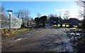
Entrance of a sewage works
The sewage works marked on the 1:250000 map is shown in Image and Image The gate shown right of centre in the present picture is its entrance. On the left is a Image
Image: © Lairich Rig
Taken: 9 Feb 2018
0.12 miles
9
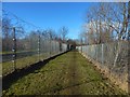
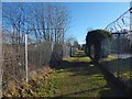
Path from Dumbarton Foreshore
As the 1:25000 map shows, the path is bounded on the left (southwest) by a sewage works (Image), and on the right (northeast) by a railway line. About 50 metres ahead, the path ends at the Image From there, a short road leads in the same direction to meet Castlegreen Street.
See Image for a view in the opposite direction along the path.
Image: © Lairich Rig
Taken: 9 Feb 2018
0.13 miles
10
Path to Dumbarton Foreshore
The start of the path is shown on the left in Image As the 1:25000 map shows, the path is bounded on the left (northeast) by the railway line and on the right by sewage works (Image). See Image for a view in the opposite direction.
Image: © Lairich Rig
Taken: 9 Feb 2018
0.14 miles