IMAGES TAKEN NEAR TO
Denny Crescent, DUMBARTON, G82 1JL
Introduction
This page details the photographs taken nearby to Denny Crescent, G82 1JL by members of the Geograph project.
The Geograph project started in 2005 with the aim of publishing, organising and preserving representative images for every square kilometre of Great Britain, Ireland and the Isle of Man.

There are currently over 7.5m images from over14,400 individuals and you can help contribute to the project by visiting https://www.geograph.org.uk
Image Map
Images are licensed for reuse under creativecommons.org/licenses/by-sa/2.0
Notes
- Clicking on the map will re-center to the selected point.
- The higher the marker number, the further away the image location is from the centre of the postcode.
Image Listing (176 Images Found)
Images are licensed for reuse under creativecommons.org/licenses/by-sa/2.0
Image
Details
Distance
1
Denny Crescent, Dumbarton
This street is part of the Castle Quay housing development. The name Denny Crescent commemorates the former presence here of the northern part of Denny's shipyard. At a still earlier period, and as shown on the first-edition OS map (surveyed in 1860), this northern part had previously been the site of the Victoria Yard (of Denny & Rankin): see Image
(For the company Denny & Rankin, see the comments at http://www.geograph.org.uk/article/Dumbarton-Cemetery#shipbuilding-and-other-industries on Peter Denny of Castlegreen and on Daniel Rankin. For the place-name Castlegreen, see comments on Image)
Image: © Lairich Rig
Taken: 21 Feb 2013
0.01 miles
2
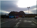
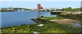
Waste recycling centre, Dumbarton
Behind Morrisons. Looking to Dumbarton rock.
Image: © Stephen Sweeney
Taken: 25 Nov 2007
0.05 miles
3
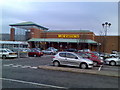
Morrisons, Dumbarton
Looking to the front entrance from the car park.
Image: © Stephen Sweeney
Taken: 25 Nov 2007
0.06 miles
4

Wallace Street
With Denny Road in the background. Viewed from Glasgow Road.
Image: © Thomas Nugent
Taken: 24 Apr 2011
0.06 miles
5
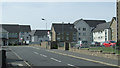
Denny Road
Housing on a former industrial site off Castle Road.
Image: © Thomas Nugent
Taken: 12 Jul 2013
0.06 miles
6
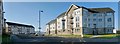
Castle Quay housing development
The backdrop consists largely of Image, with double-peaked Dumbowie Hill – http://www.geograph.org.uk/snippet/266 – visible on the right, behind the floodlights of Image The tip of Sandpoint (Image) is visible at the left-hand edge of the photograph.
For another view of the same development, see Image The present photograph was taken from Image
Image: © Lairich Rig
Taken: 30 Jan 2012
0.08 miles
7

Victoria Street
Looking towards Castle Road and Dumbarton Rock and castle beyond.
Image: © Richard Sutcliffe
Taken: 1 Sep 2023
0.08 miles
8

Castlegreen Street
Victoria Street is to the right.
Image: © Thomas Nugent
Taken: 12 Jul 2013
0.09 miles
9
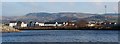
View of Dumbarton Distillery
View of Dumbarton Distillery and river Leven from near Dumbarton Football Ground
Image: © George Rankin
Taken: 27 Apr 2002
0.09 miles
10
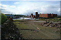
The former site of Denny's shipyard
The foreground area of the shore was part of Denny's shipyard (the Leven Shipyard and Engine Works, operated by William Denny and Brothers). This northern part of the Leven Shipyard had earlier been part of the Victoria Yard (of Denny and Rankin), but the Leven Shipyard would be extended further to the south to include the Castlegreen area, so that it would reach as far as to the foot of Dumbarton Rock; compare Image
In the background, Sandpoint (Image) is on the left, with a light-blue building on it. The Image are prominent above the centre of the photo, with Image to their left. To the right of the distillery's brick tower are the spire of Image and the top of the Image
Image: © Lairich Rig
Taken: 25 May 2012
0.10 miles