IMAGES TAKEN NEAR TO
Blantyre Crescent, CLYDEBANK, G81 6JW
Introduction
This page details the photographs taken nearby to Blantyre Crescent, G81 6JW by members of the Geograph project.
The Geograph project started in 2005 with the aim of publishing, organising and preserving representative images for every square kilometre of Great Britain, Ireland and the Isle of Man.

There are currently over 7.5m images from over14,400 individuals and you can help contribute to the project by visiting https://www.geograph.org.uk
Image Map
Images are licensed for reuse under creativecommons.org/licenses/by-sa/2.0
Notes
- Clicking on the map will re-center to the selected point.
- The higher the marker number, the further away the image location is from the centre of the postcode.
Image Listing (30 Images Found)
Images are licensed for reuse under creativecommons.org/licenses/by-sa/2.0
Image
Details
Distance
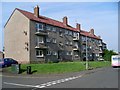
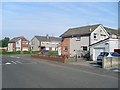
1
Blantyre Crescent, Duntocher
Lovely backdrop, if only my back garden looked onto this...
Image: © Stephen Sweeney
Taken: 22 Jul 2007
0.06 miles
2
Blantyre Crescent, Duntocher
With a fine view to the Kilpatrick Hills.
Image: © Stephen Sweeney
Taken: 24 Jul 2008
0.06 miles
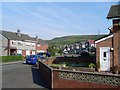
3
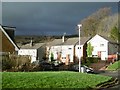
Blantyre Crescent, Duntocher
The houses back onto the lower slopes of the Kilpatrick Hills.
Image: © Richard Sutcliffe
Taken: 11 Oct 2019
0.06 miles
4
Houses on Blantyre Crescent
In Duntocher.
Image: © Stephen Sweeney
Taken: 24 Jul 2008
0.08 miles
5
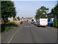
Looking west on Craigielea Road
Towards Blantyre Crescent from the top of Redmoss Road.
Image: © Stephen Sweeney
Taken: 24 Jul 2008
0.08 miles
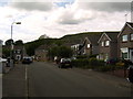
6
Beeches Road, Duntocher
A street in the small town of Duntocher.
Image: © Stephen Sweeney
Taken: 13 Mar 2007
0.08 miles
7
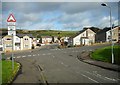
Humps in all directions
Junction of Dalgleish Avenue, Beeches Road (running left to right) and Craigielea Road (straight on). All have speed bumps. The photograph is taken from the point where Dalgleish Avenue crosses the line of the Antonine Wall, and so this junction is actually part of a World Heritage Site https://www.historicenvironment.scot/advice-and-support/listing-scheduling-and-designations/world-heritage-sites/antonine-wall/.
Image: © Richard Sutcliffe
Taken: 11 Oct 2019
0.09 miles
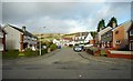
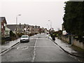
8
Craigielea Road
The uphill edge of Duntocher.
Image: © Richard Webb
Taken: 4 Jan 2016
0.13 miles
9
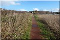
The Thomas Wood Path
This is a view from about halfway along the path, looking east, towards the point where it meets the western end of Beeches Road in Duntocher.
Image: © Lairich Rig
Taken: 10 Mar 2014
0.14 miles