IMAGES TAKEN NEAR TO
Glasgow Road, CLYDEBANK, G81 1JP
Introduction
This page details the photographs taken nearby to Glasgow Road, G81 1JP by members of the Geograph project.
The Geograph project started in 2005 with the aim of publishing, organising and preserving representative images for every square kilometre of Great Britain, Ireland and the Isle of Man.

There are currently over 7.5m images from over14,400 individuals and you can help contribute to the project by visiting https://www.geograph.org.uk
Image Map
Images are licensed for reuse under creativecommons.org/licenses/by-sa/2.0
Notes
- Clicking on the map will re-center to the selected point.
- The higher the marker number, the further away the image location is from the centre of the postcode.
Image Listing (63 Images Found)
Images are licensed for reuse under creativecommons.org/licenses/by-sa/2.0
Image
Details
Distance
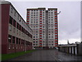
1
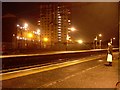
Yoker Flats from Yoker Station
Officially known as Clydebank East, this area is locally named the Yoker Flats.
Image: © Stephen Sweeney
Taken: 4 Dec 2008
0.05 miles
2
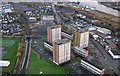
Yoker towerblocks from the air
Yoker railway station is on the left, with part of Yoker railway depot beyond. The main road is the A814 Dumbarton Road, the River Clyde can be seen top right.
Image: © Thomas Nugent
Taken: 17 Nov 2017
0.06 miles
3
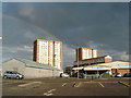
Double Rainbow over Yoker
The name Yoker is an Anglicization of the Scottish Gaelic Iochdar meaning a low lying place; the name was attested for the first time in 1505.
Image: © Darrin Antrobus
Taken: 10 May 2007
0.06 miles
4
Yoker Highrise flats
From the cycle path behind Holm Park.
Image: © Stephen Sweeney
Taken: 18 Dec 2008
0.07 miles
5
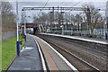
An easterly view along the platform of Yoker railway station in Glasgow
The platforms at Yoker railway station in Glasgow. Yoker is in the very west of Glasgow at the border with Clydebank. The next westbound station on the line is Clydebank whilst the next eastbound station in Garscadden.
Image: © Garry Cornes
Taken: 3 Jan 2016
0.07 miles
6
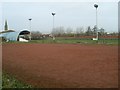
Holm Park
Home of Junior football side Yoker Athletic. Also the current temporary home of the Clydebank junior football team.
Image: © Stephen Sweeney
Taken: 18 Dec 2008
0.07 miles
7
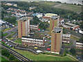
Yoker towerblocks from the air
Known as Clydebank East, the towerblocks are, from left to right, Howcraigs Court, Newshot Court and Edmonstone Court. Each block contains 110 apartments. Occupation rates were around 50% in 2015, at which time it was decided by West Dunbartonshire Council that the entire estate should be demolished. The last residents moved out in September 2018 and demolition began shortly afterwards.
Yoker railway station is in the lower left corner, the River Clyde is in the background.
Image: © Thomas Nugent
Taken: 6 Sep 2019
0.08 miles
8
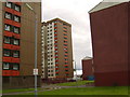
Clydebank East Highrise Flats
Known locally as the "Yoker Flats", despite not even being in Yoker - they're in Clydebank.
Image: © Stephen Sweeney
Taken: 17 Jun 2007
0.08 miles
9
Yoker Tower Block
Not a 9/11 style terrorist attack. More an aircraft on its approach path to Glasgow Airport.
Image: © Chris Upson
Taken: 28 Sep 2005
0.09 miles
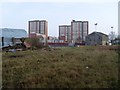
10

Cleared site
Looking down what used to be Clydeholm Terrace. Demolition of the blocks of flats that used to be here started in 2019 and have all now been demolished.
Image: © Richard Sutcliffe
Taken: 21 Jan 2022
0.09 miles