IMAGES TAKEN NEAR TO
Eaglesham, GLASGOW, G76 0PN
Introduction
This page details the photographs taken nearby to G76 0PN by members of the Geograph project.
The Geograph project started in 2005 with the aim of publishing, organising and preserving representative images for every square kilometre of Great Britain, Ireland and the Isle of Man.

There are currently over 7.5m images from over14,400 individuals and you can help contribute to the project by visiting https://www.geograph.org.uk
Image Map
Images are licensed for reuse under creativecommons.org/licenses/by-sa/2.0
Notes
- Clicking on the map will re-center to the selected point.
- The higher the marker number, the further away the image location is from the centre of the postcode.
Image Listing (21 Images Found)
Images are licensed for reuse under creativecommons.org/licenses/by-sa/2.0
Image
Details
Distance
2
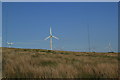
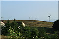
Wind Turbines at Carrot Moor
Wind turbines at Carrot Moor Farm.
Image: © edward mcmaihin
Taken: 26 Jun 2013
0.01 miles
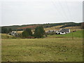
4
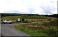
Carrot
The settlement at Carrot consists of the original farm with several other homes. Forestry lies to the west, south and east of it. A path avoiding the buildings gives access to a forest road by which Corse Hill can be ascended.
Image: © Trevor Littlewood
Taken: 10 Apr 2010
0.03 miles
5

Road arriving at Carrot Farm
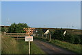
The single-track road from Eaglesham comes to an end at Carrot on the Eaglesham Moor. The remaining few yards of the road are private past this point.
Image: © Alec MacKinnon
Taken: 17 Aug 2013
0.05 miles
6
Carrot Moor Farm
Carrot Moor Farm with wind turbines in the background.
Image: © edward mcmaihin
Taken: 26 Jun 2013
0.05 miles
7
The Weavers' Trail at Carrot
The Weavers' Trail leaves the end of the public road at Carrot following a rough track through Whitelee Forest and across high ground passing Myres Hill and High Overmuir before descending to Darvel. Click on this link to proceed through Whitelee Forest http://www.geograph.org.uk/photo/1434833 or to return to Eaglesham http://www.geograph.org.uk/photo/1450602 and discover about the Weavers' Trail http://www.geograph.org.uk/article/The-Darvel-to-Eaglesham-weavers-trail . Gordon Brown has published photographs of the section of the Trail from High Overmuir to Darvel.
Image: © Kenneth Mallard
Taken: 9 Aug 2009
0.07 miles
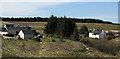
8
Carrot Moor Farm housing
Housing adjacent to Carrot Moor Farm.
Image: © edward mcmaihin
Taken: 26 Jun 2013
0.08 miles
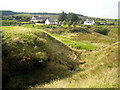
10
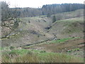
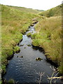
Carrot Burn
Flowing in a small but well defined valley beside Carrot Farm.
Image: © G Laird
Taken: 15 Apr 2014
0.09 miles