1
Glendinning Place
The Secession Church broke away from the established church in 1733 and established a church of the Burgher Faction, the Cameronian Church in Glendinning Place. Sometime after the church closed, the meeting house became the Old Concert Hall for a time before being converted to a private residence. Click on these links to discover about the churches and Covenanters http://www.geograph.org.uk/photo/1424798 http://www.geograph.org.uk/photo/1897780 http://www.geograph.org.uk/photo/1432415 .
Image: © Kenneth Mallard
Taken: 30 Apr 2011
0.13 miles
2
Masonic Lodge, Eaglesham, Scotland.
Lodge Eaglesham No.1265, Eaglesham, Scotland.
Image: © Jim Campbell
Taken: 27 Jul 2007
0.17 miles
3
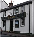
Swan Inn
The Swan Inn, 23 Polnoon Street, was tacked as a two storey house in 1774 and later converted to an inn in 1832. The New Statistical Account of Scotland, 1840, noted that 'Alehouses. - There are 15 public-houses in the parish. They are rather in the decrease.' Links to other hotels and inns http://www.geograph.org.uk/photo/1875376 http://www.geograph.org.uk/photo/1484257 .
Image: © Kenneth Mallard
Taken: 20 Aug 2009
0.20 miles
4
Swan Inn
The Swan Inn, 23 Polnoon Street, was tacked as a two storey house in 1774 and later converted to an inn in 1832. The New Statistical Account of Scotland, 1840, noted that 'Alehouses. - There are 15 public-houses in the parish. They are rather in the decrease.' Links to other hotels and inns http://www.geograph.org.uk/photo/1875376 http://www.geograph.org.uk/photo/1484257 .
Image: © Kenneth Mallard
Taken: 15 Aug 2010
0.20 miles
5
The Swan Inn, Polnoon Street, Eaglesham
Category B-listed. Built 1774. Inn established 1832.
Image: © Leslie Barrie
Taken: 10 Sep 2014
0.20 miles
6
Coo Lane
Coo Lane leads off Polnoon Street http://www.geograph.org.uk/photo/1450275 near Mid Road. The lane originally led to the fields behind Polnoon Street. The building on the right (mid-photo) was once a United Presbyterian Church before the congregation moved to a new building in Montgomery Street. Click on these links to discover about the churches and Covenanters http://www.geograph.org.uk/photo/1424798 http://www.geograph.org.uk/photo/1897780 http://www.geograph.org.uk/photo/1432415 .
Image: © Kenneth Mallard
Taken: 12 Sep 2009
0.20 miles
7
Coo Lane
Coo Lane once led to the pastures behind Polnoon Street. The building in the foreground was once a United Presbyterian Church before the congregation moved to a new building in Montgomery Street. Click on these links to discover about the churches and Covenanters http://www.geograph.org.uk/photo/1424798 http://www.geograph.org.uk/photo/1897780 http://www.geograph.org.uk/photo/1432415 http://www.geograph.org.uk/photo/2385555 .
Image: © Kenneth Mallard
Taken: 30 Apr 2011
0.20 miles
8
Cottage on Polnoon Street
A single-storey cottage, which was renovated in 1956. It is Category B listed http://portal.historicenvironment.scot/designation/LB5215.
Image: © Richard Sutcliffe
Taken: 7 Mar 2022
0.20 miles
9
Polnoon Street, Eaglesham
Image: © Leslie Barrie
Taken: 10 Sep 2014
0.20 miles
10
Doorpiece - Polnoon Street
Consoled, corniced and pedimented doorpiece at a house in Polnoon Street. Plain panelled door with glass lights.
Image: © Kenneth Mallard
Taken: 3 Jan 2010
0.21 miles


