IMAGES TAKEN NEAR TO
Bonnyton Drive, GLASGOW, G76 0LS
Introduction
This page details the photographs taken nearby to Bonnyton Drive, G76 0LS by members of the Geograph project.
The Geograph project started in 2005 with the aim of publishing, organising and preserving representative images for every square kilometre of Great Britain, Ireland and the Isle of Man.

There are currently over 7.5m images from over14,400 individuals and you can help contribute to the project by visiting https://www.geograph.org.uk
Image Map
Images are licensed for reuse under creativecommons.org/licenses/by-sa/2.0
Notes
- Clicking on the map will re-center to the selected point.
- The higher the marker number, the further away the image location is from the centre of the postcode.
Image Listing (125 Images Found)
Images are licensed for reuse under creativecommons.org/licenses/by-sa/2.0
Image
Details
Distance
1
Glendinning Place
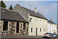
The Secession Church broke away from the established church in 1733 and established a church of the Burgher Faction, the Cameronian Church in Glendinning Place. Sometime after the church closed, the meeting house became the Old Concert Hall for a time before being converted to a private residence. Click on these links to discover about the churches and Covenanters http://www.geograph.org.uk/photo/1424798 http://www.geograph.org.uk/photo/1897780 http://www.geograph.org.uk/photo/1432415 .
Image: © Kenneth Mallard
Taken: 30 Apr 2011
0.04 miles
2
Masonic Lodge, Eaglesham, Scotland.
Lodge Eaglesham No.1265, Eaglesham, Scotland.
Image: © Jim Campbell
Taken: 27 Jul 2007
0.07 miles
3

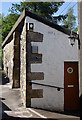
Doorpiece - Polnoon Street
Consoled, corniced and pedimented doorpiece at a house in Polnoon Street. Plain panelled door with glass lights.
Image: © Kenneth Mallard
Taken: 3 Jan 2010
0.11 miles
4
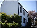
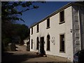
The Old Bakehouse
The Old Bakehouse is tucked behind a house in Polnoon Street.
Image: © Kenneth Mallard
Taken: 24 May 2010
0.11 miles
5
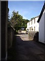
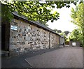
Coo Lane
Coo Lane leads off Polnoon Street http://www.geograph.org.uk/photo/1450275 near Mid Road. The lane originally led to the fields behind Polnoon Street. The building on the right (mid-photo) was once a United Presbyterian Church before the congregation moved to a new building in Montgomery Street. Click on these links to discover about the churches and Covenanters http://www.geograph.org.uk/photo/1424798 http://www.geograph.org.uk/photo/1897780 http://www.geograph.org.uk/photo/1432415 .
Image: © Kenneth Mallard
Taken: 12 Sep 2009
0.11 miles
6
Coo Lane
Coo Lane once led to the pastures behind Polnoon Street. The building in the foreground was once a United Presbyterian Church before the congregation moved to a new building in Montgomery Street. Click on these links to discover about the churches and Covenanters http://www.geograph.org.uk/photo/1424798 http://www.geograph.org.uk/photo/1897780 http://www.geograph.org.uk/photo/1432415 http://www.geograph.org.uk/photo/2385555 .
Image: © Kenneth Mallard
Taken: 30 Apr 2011
0.11 miles
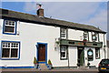
7
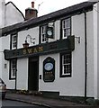
Swan Inn
The Swan Inn, 23 Polnoon Street, was tacked as a two storey house in 1774 and later converted to an inn in 1832. The New Statistical Account of Scotland, 1840, noted that 'Alehouses. - There are 15 public-houses in the parish. They are rather in the decrease.' Links to other hotels and inns http://www.geograph.org.uk/photo/1875376 http://www.geograph.org.uk/photo/1484257 .
Image: © Kenneth Mallard
Taken: 20 Aug 2009
0.11 miles
8
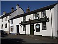
Swan Inn
The Swan Inn, 23 Polnoon Street, was tacked as a two storey house in 1774 and later converted to an inn in 1832. The New Statistical Account of Scotland, 1840, noted that 'Alehouses. - There are 15 public-houses in the parish. They are rather in the decrease.' Links to other hotels and inns http://www.geograph.org.uk/photo/1875376 http://www.geograph.org.uk/photo/1484257 .
Image: © Kenneth Mallard
Taken: 15 Aug 2010
0.11 miles
9
The Swan Inn, Polnoon Street, Eaglesham
Category B-listed. Built 1774. Inn established 1832.
Image: © Leslie Barrie
Taken: 10 Sep 2014
0.11 miles